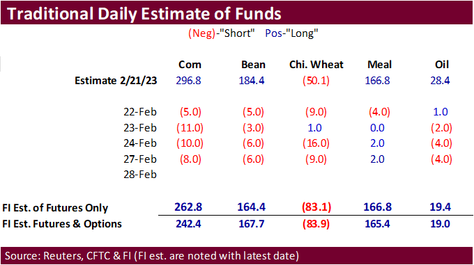
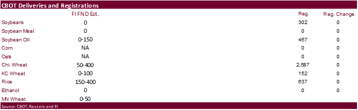
PDF Attached
WTI crude oil and USD were both lower. US equities were higher. CBOT wheat fell on large stockpiles. Corn and soybeans continued its liquidation from last week. US Great Plains winter wheat areas saw an improvement in weather after last week’s coast to coast storm system and forecast for additional precipitation this week. Black Sea competition is also weighing on wheat. Traders are expecting the Black Sea grain corridor deal to be extended. Argentina is not expected to see much rain over the next week.
MOST IMPORTANT WEATHER FOR THE DAY
- Rain fell across portions of U.S. hard red winter wheat areas overnight with the high Plains region getting restricted amounts of moisture
- Most of the rainfall varied from 0.10 to 0.50 inch in the interior west of Kansas while 0.10 to 0.76 inch occurred from Oklahoma to central and eastern parts of Kansas
- Local totals reached over 1.00 inch in central and northwestern Oklahoma
- As much as 1.76 inches of moisture occurred in central Oklahoma
- California has received substantial precipitation during the weekend
- One to 3.34 inches of rain occurred in the central and southern parts of the San Joaquin Valley
- Rainfall along the lower coast of California from Santa Maria into the Los Angeles Basin reported 3.00 to 6.34 inches with a local total of 9.52 inches at Rose Valley
- Northern portions of the San Joaquin Valley much lighter rain during the weekend, but will get significant moisture over the next two days
- California’s Sierra Nevada will receive 1.00 to 3.00 inches of moisture today and again Tuesday before quieter weather evolves
- Snow accumulations will vary from 3 to 6 feet in the Sierra Nevada during the next two and a half days
- California’s water supply will continue to improve over the next few weeks as precipitation falls and mountain snowpack begins to melt
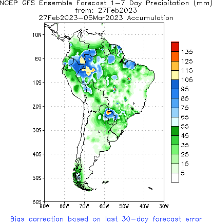
- Argentina rainfall during the weekend was minimal and net drying resulted
- Highest temperatures were in the in the 90s Fahrenheit with morning lows in the upper 40s and 50s in the south and in the 60s in the north
- Argentina will not get enough rain to counter evaporation in the central or south for the next ten days
- Far northern Argentina will experience waves of rain late this week into next week that will improve soil and crop conditions in cotton, dry bean, citrus and sugarcane producing areas from Salta to Formosa and northern Chaco
- Some minor grain and oilseed areas in the north will also benefit from the moisture, but other areas will be missed by significant precipitation
- Argentina’s bottom line has not changed much from that of last Friday. The bulk of central and southern Argentina will not receive enough rain to counter evaporation or to seriously change crop or field conditions in the next ten days. Northern Argentina crops will experience some improvement with cotton benefiting most from the rain. Some rain will develop in the second week of March, but early indications do not suggest a general soaking and most crop areas will still be looking for a more meaningful rain to stop the decline in production potentials.
- Brazil rainfall during the weekend was greatest from central and eastern Mato Grosso into southwestern Minas Gerais, a part of Sao Paulo, Mato Grosso do Sul and central through northern Paraguay
- Amounts varied from 0.60 to 0 1.73 inches with local totals to 3.86 inches in southern Goias and 7.40 inches in west-central Mato Grosso
- Rain also fell in Rio Grande do Sul with northwestern areas getting 0.75 to 1.69 inches and other areas reported 0.20 to 0.62 inch with a few amounts to 1.25 inches
- Net drying occurred in the interior southern and northeastern summer crop areas
- Temperatures were seasonable
- Routinely occurring rain is expected in Brazil during the coming ten days to two weeks
- Bahia, northeastern Minas Gerais and Espirito Santo will be driest with 0.25 to 0.80 inch and a few amounts to 1.50 inches likely
- Rio Grande do Sul will receive 1.00 to 2.0 inches of rain while most other areas get 1.00 to 3.00 inches with a few totals to 5.00 inches
- Wettest in Parana, Mato Grosso do Sul, Sao Paulo and southern Goias
- Paraguay rainfall is expected to be greater than that of Brazil with some central and northern crop areas getting 3.00 to more than 8.00 inches of rain by the middle part of next week
- Brazil’s bottom line is relatively normal for the next two weeks. Fieldwork will be slow in Parana, Paraguay, Mato Grosso do Sul, Sao Paulo and southern Goias due to saturated soil conditions and periodic rainfall. Rio Grande do Sul will get just enough rain to maintain favorable crop and field conditions, despite early season crop moisture stress. Drying in Bahia and immediate neighboring areas may lead to some crop moisture stress as the region dries out. Mato Grosso fieldwork will advance relatively well over the next two weeks with planting and harvesting advancing around daily showers and thunderstorms.
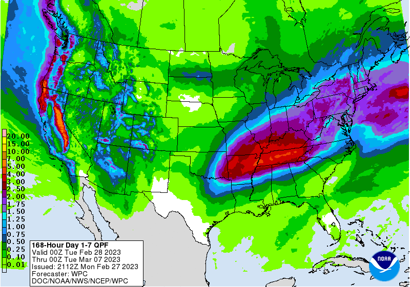
- U.S. Midwest, Delta and Tennessee River Basin will receive frequent rain over the next two weeks leaving the soil saturated and vulnerable to some local flooding
- Rain totals of 2.00 to 4.00 inches are expected by mid-week next week in the Tennessee River Basin, northern Delta and Ohio River Basin
- Rainfall of 0.30 to 1.25 inches will occur in the northwestern half of the Midwest with some areas in South Dakota, Minnesota and Nebraska getting less than 0.75 inch and several areas will get less than 0.40 inch
- North America temperatures this week and early next week will be colder than usual in the western parts of both the United States and Canada while temperatures are warmer biased in the Midwest, Delta, southern Plains and Atlantic Coast States
- Some of the cold in the west will begin spreading to the east in the second week of March including much of the Great Plains and part of the Midwest
- Drought in northeastern Mexico, South Texas, the Texas Coastal Bend and West Texas will prevail over the next ten days, despite a few brief showers of limited significance
- Delays in the start of spring planting will be possible in unirrigated areas
- Florida, southern Georgia, southern South Carolina, southern Alabama, southern Mississippi and much of central, western and southern Texas will receive restricted rainfall during the next ten days
- Totally dry weather is not expected, but net drying will be the rule
- Some increase in rainfall is predicted for the second week of the outlook
- U.S. northern Plains will be wettest during mid-week this week and again during the early part of next week
- Snow will fall most often, but no large storm system is expected until the second week of March and confidence in that event is quite low
- U.S. Midwest weekend precipitation
- Rain and thunderstorms moved across eastern Nebraska and eastern Kansas to southern Wisconsin, Illinois and a part of Indiana during the weekend
- Significant relief from dryness occurred from southwest to northeast across Iowa where 1.00 to 2.00 inch moisture totals were noted
- Iowa is in much better moisture shape today than it was a few weeks ago which sets the stage for a favorable planting season if the moisture remains through March
- U.S. northern Delta and interior southeastern parts of the nation received rain during the weekend with just enough to maintain moist field conditions.
- Net drying has been occurring recently in the lower Delta and far southeastern corner of the nation; including Florida
- U.S. temperatures were mild to cool during the weekend in the west and some central crop areas while warm biased in the southeastern states
- Highest temperatures were in the 70s and 80s from southern and eastern Texas through the lower Delta to the Carolinas, Georgia and Florida
- Sub-zero Fahrenheit temperatures occurred in the northern Plains and upper Midwest as well as the northeastern states
- Europe precipitation during the weekend was greatest from central Italy through the western and northern Balkan Countries into Belarus and the Baltic States as well as a part of Poland where 0.20 to 0.72 inch occurred often with some totals of 1.00 to 2.00 inches in the northern Balkans
- Temperatures were cooler biased especially in the central and south
- Southern Europe will be stormy this week into early next week form through Italy to the lower Danube River Basin
- Moisture totals by mid-week next week may vary from 0.20 to 1.00 inch in the Iberian Peninsula with a few totals over 2.00 inches
- Greatest rain will occur from Italy into Serbia and Bulgaria where 1.00 to more than 3.00 inches will result
- Montenegro will be wettest along with parts of Albania with additional amounts getting close to 5.00 inches result in local flooding
- Northern Europe will not be completely dry, but precipitation amounts will be very light
- Temperatures will also be cooler biased across much of Europe, but especially in the north
- Northern Europe will trend wetter in the second week of March
- Southwestern Russia continued to receive abundant moisture along with Belarus where more than 1.00 inch of moisture resulting from rain and snow resulted Friday through Sunday
- Some very heavy snow accumulation was suspected in the cooler areas
- Western CIS crop weather will continue wet over the next ten days with waves of snow and rain expected to continue
- Flood potentials continue to rise for this spring due to saturated soil and significant snow accumulations on top of the ground
- Additional moisture totals this week will vary from 0.30 to 1.00 inch with a few 1.00- to 2.00-inch totals
- Europe and Asia temperatures will remain warmer than usual during the coming two weeks except in southwestern Europe early this week and from Scandinavia through northwestern Russia next week when cooler than usual conditions are likely.
- India was mostly dry during the weekend and it will continue quite dry for one more week
- Some central India showers will develop lightly in the second week of March, but the precipitation may fall too late and be too light to seriously change winter crop yield potentials
- Far southern and extreme northern India will get greater rain over the next two weeks benefiting a few crops, but the majority of the nation will need greater rain sooner than that to induce the best winter crop yields and quality in unirrigated areas
- Eastern China precipitation will continue restricted over the next ten days to two weeks except from southern Sichuan to Yunnan where rain will fall periodically to maintain a good environment for crops
- Net drying is likely in most other areas
- Rain will have to evolve soon in rapeseed areas to ensure a good start to aggressive crop development
- Wheat areas have favorable soil moisture and crops are still dormant, but gradual drying is expected through the first half of March
- Australia’s summer crop areas failed to get much moisture during the weekend, although Victoria and southeastern South Australia received 0.15 to 1.00 inch of moisture
- A few coastal areas along the lower Queensland and New South Wales coast did receive light rain
- Heavier rain fell in the Cape York Peninsula where more than 10.00 inches occurred in a small area near Cairns, Queensland
- Eastern Australia’s dryland cotton, sorghum and other summer crops are unlikely to get much precipitation over the next ten days resulting in additional crop stress and lower production potentials
- Irrigated crops in eastern Australia continue in good condition with normal to above normal yields expected
- Drought remains a serious concern in the central and interior southwestern Canada Prairies where timely late winter and spring precipitation will be needed this year to support planting and initial crop development.
- Snow will fall later this week into next week from western and southern Alberta into southwestern Saskatchewan while precipitation elsewhere will be restricted
- Tropical Cyclone Freddy moved into Mozambique during the weekend and dissipated resulting in some crop and property damage due to flooding and some strong wind
- Damage from the storm was greatest in Madagascar late last week
- The storm produced very heavy rain and induced damaging wind as well as some flooding over southern and east-central Madagascar impacting grain, oilseed, rice, coffee, sugarcane and other crops earlier this week
- Recent rain in Philippines lightened up last week after too much rain fell in the previous weekend
- Weather conditions in the next ten days should be mostly good for the nation
- Indonesia and Malaysia rainfall will occur abundantly during the next two weeks with all areas impacted and no area experiencing much net drying
- South Africa rainfall will be restricted for the early to middle part of this week, although a few showers will be around
- Greater rain is expected to slowly evolve once again over key summer crop areas during the latter part of this week and especially next week
- West-central Africa rainfall increased during the weekend in southeastern Ivory Coast and southern Ghana with a few 1.00 to 1.69-inch amounts resulting. Other areas continued to experience net drying
- A seasonal increase in rainfall is expected to continue gradually over the next two week helping coffee, cocoa, rice and sugarcane to begin development normally
- Middle East precipitation is expected to be erratic and sometimes light over the next couple of weeks raising some need for greater precipitation prior to cotton and rice planting season.
- Wheat conditions are rated favorably, but would benefit from additional rain
- Turkey should be wettest while Syria, Iraq and Lebanon need greater rainfall
- Eastern Africa precipitation will be greatest in Tanzania during the next ten days which is not unusual at this time of year
- Some rain is expected to develop in Ethiopia, Uganda and Kenya over time, although amounts should be light
- Sunday’s Southern Oscillation Index was +10.64 and it was expected to move erratically over the next week
Source: World Weather and FI
Monday, Feb. 27:
- USDA export inspections – corn, soybeans, wheat, 11am
- Dubai Sugar Conference, day 1
- EARNINGS: Olam, FGV
Tuesday, Feb. 28:
- Dubai Sugar Conference, day 2
- EU weekly grain, oilseed import and export data
- US agricultural prices paid, received, 3pm
- Malaysia’s Feb. palm oil export data
- Vietnam coffee, rice and rubber export data
- EARNINGS: Golden Agri
Wednesday, March 1:
- Dubai Sugar Conference, day 3
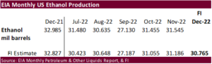
- EIA weekly US ethanol inventories, production, 10:30am
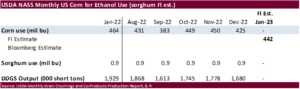
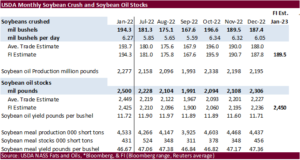
- USDA soybean crush, DDGS production, corn for ethanol, 3pm
- Global Grain and Animal Feed Asia 2023, Singapore, day 1
Thursday, March 2:
- Dubai Sugar Conference, day 4
- USDA weekly net-export sales for corn, soybeans, wheat, cotton, pork and beef, 8:30am
- Port of Rouen data on French grain exports
- Global Grain and Animal Feed Asia 2023, day 2
Friday, March 3:
- FAO World Food Price Index, grains report
- ICE Futures Europe weekly commitments of traders report
- CFTC commitments of traders weekly report on positions for various US futures and options, 3:30pm
- FranceAgriMer’s weekly crop conditions reports
- Global Grain and Animal Feed Asia 2023, day 3
Source: Bloomberg and FI
US Durable Goods Orders Jan P: -4.5% (exp -4.0%; prevR 5.1%)*
*BIGGEST MONTHLY DROP SINCE APRIL 2020 “COVID”.
Durable Ex Transportation Jan P: 0.7% (exp 0.1%; prevR -0.4%)
Cap Goods Orders Nondef Ex Air Jan P: 0.8% (exp 0.0%; prevR -0.3%)
US Pending Home Sales (M/M) Jan: 8.1% (est 1.0%; prev R 1.1%)
US Pending Home Sales NSA (Y/Y) Jan: -22.4% (prev -34.3%) ***
USDA inspections versus Reuters trade range
Wheat 591,725 versus 250000-500000 range
Corn 572,622 versus 375000-750000 range
Soybeans 690,984 versus 850000-1700000 range
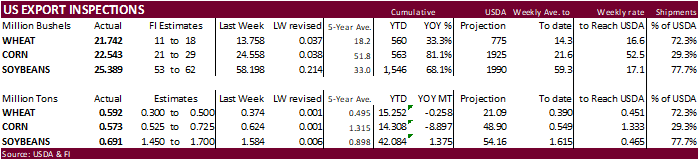
GRAINS INSPECTED AND/OR WEIGHED FOR EXPORT
REPORTED IN WEEK ENDING FEB 23, 2023