PDF Attached
-
Wednesday
is position day for CBOT January deliveries, FND is Thursday. -
We
raised most of our projected price ranges for corn and soybeans. -
Attached
is our updated US 2021-22 wheat by class supply estimates. -
USDA
export sales estimates are included in the PDF.

MOST
IMPORTANT WEATHER OF THE DAY
- No
major theme changes were noted overnight for South America - Argentina
received some rain in nearly half of the nation overnight - Amounts
were greatest in Cordoba, southeastern Santiago del Estero, parts of central Santa Fe and south-central into northeastern Buenos Aires where 0.50 to 1.14 inches resulted - Temperatures
were still warm, but not has hot as the weekend in the central and south with highs in the 80s and lower 90s; extremes in the far north were in the 90s to 104 degrees Fahrenheit - Argentina
will see sporadic showers of limited significance today and Wednesday with most of Wednesday’s moisture in the north - Net
drying is expected Thursday through the first half of next week - Rain
that falls late next week and into the following weekend is not very likely to be enough to counter evaporation in very many areas - Some
increase in rainfall is possible in the south infrequently and briefly late next week into the following week, but confidence is low - Argentina
temperatures will be warmer biased this week and could become hot in the north during the Jan. 6-12 period - Brazil
rainfall overnight was concentrated on areas from Parana to southern Minas Gerais where 0.05 to 0.50 inch occurred often and local totals close to 1.00 inch - Net
drying occurred in many areas - Temperatures
were warmest in the west-central and southwest where extremes in the 90s the near 100 were noted
- Brazil’s
weather outlook remains mostly unchanged for the next two weeks with frequent precipitation in center west and center south production areas and net drying in the far northeast and extreme south - Rain
in Mato Grosso will be greatest this week and beyond, but limited rainfall may occur for the balance of this week - Crop
moisture stress will eventually impact parts of Rio Grande do Sul and neighboring areas, but there will be a couple of timely rain events to slow net drying briefly - Some
brief rainfall is expected in northeastern Brazil this weekend and early next week and many crops will benefit from the moisture - Brazil
temperatures will be near average during both weeks of the outlook - South
Africa will experience erratic daily rainfall over the next two weeks eventually benefiting all agricultural areas - Daily
rainfall will vary widely with some areas getting more than others, but sufficient amounts will occur to suffice the needs of most crops - Temperatures
will be seasonable - Precipitation
Monday was sporadic and light leading to net drying for much of the nation - Australia
rainfall in northern New South Wales and in a few Queensland locations Monday was welcome, but not nearly enough suffice crop moisture needs in dryland production areas - Temperatures
were seasonable - Eastern
Australia weather during the next two weeks will be sufficient to support sorghum, cotton and other summer crops - Rainfall
will be periodic and highly variable, but most areas will be impacted at one time or another and crop development should improve for the driest areas - India
weather Monday was dry with a few bouts of light frost and brief freezes of limited significance in the north today
- None
of the frost had a negative impact on winter crops which are still in the pre-reproductive phase of development - Northern
India winter crop areas will get rain Saturday into Tuesday benefiting wheat and some minor rapeseed production areas - Pre-reproductive
crop conditions will improve wherever the rain falls - Moisture
totals may range from 0.20 to 0.80 inch and locally more - Brief
periods of rain will also continue in far southern India on a near-daily basis during the next couple of weeks - The
moisture may hinder some farming activity; including late season harvesting, but no crop quality issues are expected - China
winter crops will remain dormant through the next two weeks - Cold
air in eastern Russia and Mongolia will be closely monitored for possible influence in winter wheat production areas a week from now, but there is no threat of damaging cold until then and most likely the cold airmass will moderate by that time - Precipitation
will be confined to east-central China today and Wednesday and then mostly dry for at least a week - Southeast
Asia rainfall was relatively light and insignificant Monday - Periodic
precipitation is expected through the next ten days in Indonesia, Malaysia and Philippines while only coastal areas of Vietnam are impacted on the mainland - The
moisture will be good for most crops impacted - Russia
and Ukraine weather will not change much over the next two weeks - Frequent
precipitation from eastern Europe into Ukraine, Belarus and western Russia is expected
- Snow
cover will be deep and moisture potentials from melting snow in the spring are good - Russia’s
Southern Region may get some precipitation next week and any precipitation will be welcome - No
threatening cold is expected in snow free areas anytime soon - Europe
will remain plenty moist over the next two weeks with frequent waves of rain and mountain snow anticipated
- Some
heavy rain and local flooding will impact southwestern France northern Spain, Italy and the eastern Adriatic Sea nations - Some
of these wetter areas will receive 2.00 to more than 6.00 inches of rain in the coming week - Temperatures
will be mild to cool in the west and warm in the east - Southwestern
Morocco remains in a drought with little relief expected for a while - Some
rain is possible early to mid-week next week, but it will be brief and light - Northwestern
Algeria also has need for rain and it should get some of that briefly in the coming week
- Soil
moisture in other North Africa crop areas is rated mostly good - U.S.
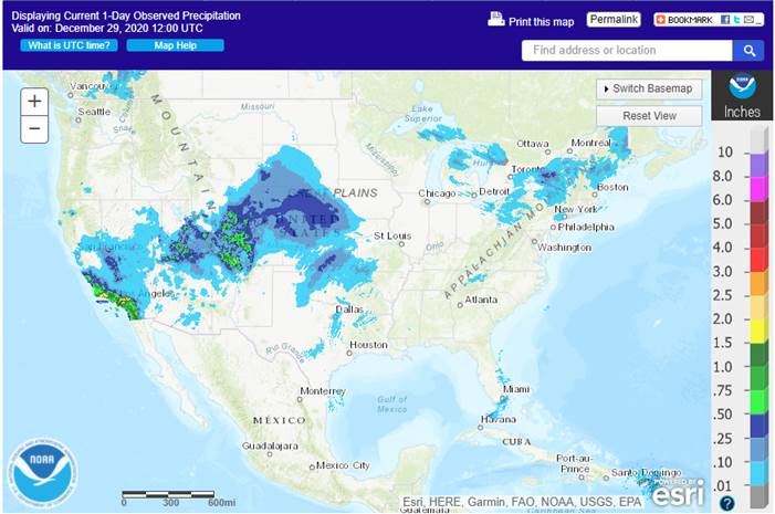
Weather Monday was mostly quiet , although snow, sleet and freezing rain evolved in the central Plains overnight and some beneficial rain fell in southern California and in a part of the central Rocky Mountains - Snow
accumulations in the central Plains ranged from a trace to 4 inches through dawn today - U.S.
Weather over the next ten days will be more active in the eastern half of the nation - Today’s
storm in the Plains will move through the Midwest this afternoon and Wednesday - Snow
will accumulate 1-3 inches in the northern Plains and 3 to 6 inches with local totals to 10 inches from central Nebraska through a part of Iowa to Michigan - Rainfall
will fall to the south - A
follow up storm is expected to evolve in southeastern Texas late Wednesday and Thursday and lift to the northeast late Thursday into Saturday - Widespread
rain is expected in the lower Midwest, Delta and southeastern states - Freezing
rain, sleet and snow will occur from eastern Kansas to the Great Lakes region - Snowfall
of 2 to 6 inches and local totals to 10 inches will occur in central Kansas and possibly in a part of northwestern Missouri, Iowa and Wisconsin from the same storm - Rain
in the Delta and southeastern states will be sufficient to delay farming activity for a while
- Local
flooding might occur in eastern Oklahoma and a few neighboring areas into southern Illinois and southern Missouri - One
more storm is expected in the second half of next week with a possible follow up event in the following weekend - North
America temperatures will be warmer than usual in Canada, the north-central U.S. and in most areas east of the Mississippi River in the coming week - Next
week’s temperatures will trend colder in the western and north-central states and staying mostly unchanged elsewhere - U.S.
hard red winter wheat areas will be driest in the west-central and southwest during the next two weeks - Additional
snowfall is expected in Nebraska today with another 1-3 inches on top of 1 to 4 inches noted overnight - Additional
rain will fall in southeastern parts of the wheat today and Wednesday with more rain and some snow possible Thursday into Friday - Heavy
snowfall is possible Thursday night and early Friday in north-central Oklahoma and central Kansas - Another
mix of light precipitation will be possible late next week and into the following weekend - The
bottom line leaves the high Plains region without much significant moisture, but some brief periods of light precipitation are possible without having much impact on the long term condition of crops and soil in the region - U.S.
northern Plains - No
major storms are expected in the next two weeks; only light snowfall will impact eastern parts of the region periodically - Snowfall
this week will be greatest today when 1 to 3 inches and local totals to 6 inches will impact South Dakota, the southeast half of North Dakota and Minnesota - Southeastern
South Dakota will be the only region getting more than 3 inches today - Not
much other “significant” precipitation is expected through mid-week next week - Far
southwestern U.S. crop areas will remain drier biased over the next two weeks, although a little shower activity is expected today into Thursday with moisture totals of 0.05 to 0.35 inch except in the Rolling Plains of Texas where more than 0.60 inch will
result. - U.S.
Delta and southeastern states will remain plenty moist over the next two weeks with the greatest rain event expected in the Delta Wednesday through Friday of this week when some 1.00 to 2.50-inch amounts will be possible (wettest in the north). The southeastern
states will experience rainfall of 0.75 to 2.00 inches - Another
weather system will occur in the latter part of next week - U.S.
Pacific Northwest will experience frequent waves of rain and mountain snowfall during the next couple of weeks - Waves
of rain and mountain snow will fall across the Sierra Nevada with periods of rain in northern California over the next two weeks - The
precipitation will help improve soil moisture and mountain snowpack for better crop use in the spring - Snowpack
in the Sierra Nevada is well below average running close to the record low of 2014, but that will soon change - West
Africa rainfall will remain mostly confined to coastal areas while temperatures in the interior coffee, cocoa, sugarcane, rice and cotton areas are a little warmer than usual over the next ten days - East-central
Africa rainfall will continue limited in Ethiopia as it should be at this time of year while frequent showers and thunderstorms impact Tanzania, Kenya and Uganda over the next ten days - Southern
Oscillation Index remains very strong during the weekend and was at +16.37 this morning – its highest values of the current La Nina episode - Mexico
and Central America weather will continue to generate erratic rainfall -
Eastern
and far southern Mexico and portions of Central America will be most impacted by periodic moisture
Source:
World Weather Inc. and FI
Thursday,
Dec. 31:
- U.S.
Export Sales Report will be released on Thursday, December 31, 2020.
Source:
Bloomberg and FI
Corn.
-
CBOT
corn surged on Tuesday on a lower USD and rumors China bought US corn, renewing ideas China has a sever consumption deficit until the end of the 2021 harvest. We initially heard 10-14 cargos of US corn traded over the last 7 days, then later it circulated
China bought up to 2.0 million tons (over 30 cargoes @ 65,000 tons). Corn option action was again very busy with several large upside call spreads trading. One underlying bullish fundamental is that the weather forecast calls for crop stress for Argentina
over the next two weeks. Argentina
temperatures will be very hot this week, countering recent precipitation that fell over the weekend into Tuesday.
-
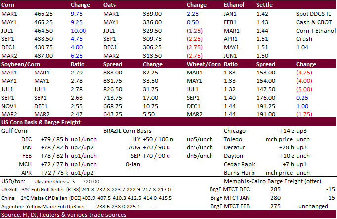
March
corn charged 9.50
cents higher to a new contract high and on track for its longest rally in 33 years, according to Bloomberg. Note we raised our price target for March corn.
-
Funds
bought an estimated net 25,000 contracts of corn. -
(downgrade
to Argentina) Soybean and Corn Advisory: 2020/21 Brazil Corn Estimate Unchanged at 102.0 Million Tons. 2020/21 Argentina Corn Estimate Lowered 1.0 mt to 46.0 Million.
-
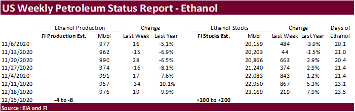
A
Bloomberg poll looks for weekly US ethanol production to be down 10,000 at 982,000 barrels (952-975 range) from the previous week and stocks up to 453,000 barrels to 23.622 million.
Corn
Export Developments
-
Qatar
seeks 100,000 tons of bulk barley on January 12.
- Qatar
seeks 640,000 cartons of corn oil on January 12.
Updated
12/29/20
March
corn is seen
trading in a $4.35 and $5.00 range. (Up 10 & 25, respectively)