PDF Attached does not include daily estimate of funds.
Schedule
Change: Weekly Export Sales Report
Because
federal government agencies will be closed on Thursday, December 24, the scheduled Export Sales Report for the week ending December 17 will be published on Wednesday, December 23, at 8:30 a.m. EST.
The
CBOT soybean complex turned higher on good soybean export sales and sharply lower USD Index along with ongoing Argentina strikes. The USD down from progress toward agreeing on a US stimulus package and a Brexit deal. Grains followed soybeans.
WORLD
WEATHER OF GREATEST INTEREST
- La
Nina Influence may become more “traditional” rest of month and into January - La
Nina is very near its peak intensity - East-central
and southeastern Argentina, Uruguay, far southern Brazil and a part of southern Paraguay will experience lighter and more sporadic rainfall than usual over time - A
boost in rain intensity and frequency will evolve from center west to center south Brazil resulting in some eventual greater than usual rainfall - Eastern
Australia rainfall is expected to increase and become more routine favoring summer crop development and improved soil moisture - Greater
rain is expected in Indonesia and Malaysia – more so in January than the balance of this month - Above
average rainfall in South Africa’s grain, oilseed and cotton areas - Greater
than usual precipitation in in portions of northern and eastern India with a slight cooler bias during the heart of winter - Above
average precipitation in the eastern U.S. Midwest and U.S. Pacific Northwest while less than usual moisture in the southern states - This
will include the west-central and southwestern Plains as well as California, the southwestern desert region, southern Rocky Mountains, Texas, Florida and immediate neighboring areas - Greater
than usual precipitation in northern Africa, a part of the Middle East and possibly parts of the Black Sea region - U.S.
National Weather Service 30- and 90-day outlooks pull no punches - Classic
La Nina forecast through March!!!!! - Southern
states drier and warmer than usual - Eastern
and northern Midwest wetter and warmer biased - Pacific
Northwest mild to cool and wet - Southwestern
states warm and dry biased - Central
and southern Plains continue warmer and drier than usual - Argentina’s
rain forecast for Friday remains good for some areas and disappointing for other areas - Rainfall
of 0.40 to 1.50 inches and local totals to 2.00 inches or more will occur from Cordoba and Santa Fe into western Buenos Aires and La Pampa - The
precipitation will help ease chronic dryness, but will not carry crops very long without additional moisture - Topsoil
moisture is very short and subsoil moisture short in these areas – the rain could not occur at a more critical time - Rainfall
of 0.15 to 0.40 inch and locally more will occur in central and eastern Buenos Aires which may spare winter wheat any negative impact on quality, but will raise the potential for summer grain and oilseed moisture stress in the coming week - Rain
will be more limited in northwestern Argentina where net drying is expected - Northeastern
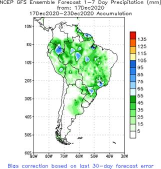
Argentina will get another 0.50 to 1.50 inches which is sufficient to maintain favorable crop development in northeastern Santa Fe, Corrientes and a few neighboring areas - Brazil’s
weather outlook has not changed much - There
is still some worry over erratic rainfall advertised in Mato Grosso, northern Mato Grosso do Sul, Bolivia, southern Goias and areas northeast into Piaui and Bahia today - These
areas will be driest through the weekend, but next week’s rain will bring some relief
- Interior
southern and center south Brazil crop areas will receive sufficient rain to support long term crop development - Southern
Paraguay and southwestern Parana along with a few far southern Mato Grosso do Sul locations were wettest overnight and more rain is expected - southern
Minas Gerais and northeastern Sao Paulo will become the greatest rain recipients this weekend and through the following week - The
greatest rain advertised for Brazil’s center west and northeastern crop areas evolves next week especially mid- to late week - Center
west Brazil will continue to be a little warm over the next several days while rainfall is most restricted and light, but will cool down with increasing rainfall next week
- Indonesia
and Malaysia rainfall recently has become a little lackluster and a boost in precipitation will eventually be needed - No
area is dry enough to pose a threat to short rooted crops, but greater volumes of rain would be welcome - The
pattern of erratic rainfall that is a little lighter than usual may prevail through the end of this month - U.S.
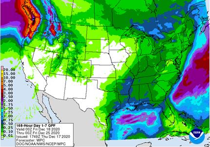
weather Wednesday brought more than 2 feet of snow to parts of southeastern New York with 10 to 24 inches in many other areas in the Mountains of Pennsylvania with lighter snow surrounding that region - Eastern
Midwest snowfall varied from 1 to 4 inches - Southeastern
states received rain with amounts to 1.00 inch in far southern Georgia and northern Florida as well as from northeastern North Carolina into Virginia - Rain
also fell in the far western states from northern California into the Pacific Northwest - Temperatures
were seasonably cool in the central states and a part of the Midwest and warm in the eastern and western most part of the nation - U.S.
weather is expected to be tranquil for a while in many, but not all areas - Periodic
storm systems will move through areas east of the Mississippi River during the next two weeks keeping those areas favorably moist - Very
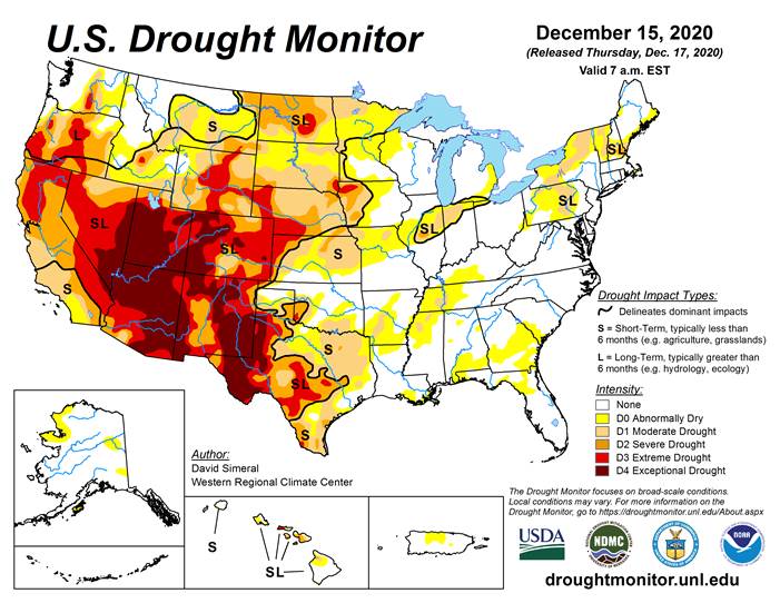
little precipitation of significance is likely in the Great Plains or western Corn Belt - Most
of the interior western and southwestern states will be dry biased for an extended period of time
- Some
cooling is likely in the north-central and eastern states during the last week of this month, but a big warm up is expected in the central and northeastern states during the weekend and first half of next week - Stormy
weather will impact the Pacific Northwest through the next two weeks keeping that region wet and slowing shipping activity periodically - U.S.
northern Plains moisture is expected to continue limited over the next ten days, although a little boost in moisture is possible during mid-week next week - U.S.
southwestern Plains will fail to get much “meaningful” moisture in the next ten days - Far
southwestern U.S. crop areas will remain drier biased over the next two weeks - U.S.
Delta and southeastern states will remain plenty moist over the next two weeks especially in the southeastern states - Eastern
Australia’s recent precipitation induced some flooding along the upper New South Wales and lower Queensland coasts
- Some
damage to sugarcane may have occurred, but other crops were not seriously impacted - Australia’s
rain in the coming ten days will advance a little farther inland favoring some important cotton and livestock areas - Many
central and eastern cotton and sorghum areas of Queensland and northeastern New South Wales will get some much needed rain to help improve planting prospects for sorghum and late season cotton - Far
southern India will receive additional showers into the weekend and then drier biased conditions are likely - Sporadic
showers will occur in other central, eastern and far northern crop areas, but most of them will not produce enough moisture to change soil or crop conditions - South
Africa will continue to receive erratic rainfall over the next two weeks resulting in good soil moisture in the central and east eventually, but some greater precipitation will be needed
- Rainfall
through this weekend will be erratic and light favoring the central and east, but a bigger boost in rainfall might be needed - Western
crop areas will get needed rain during mid- to late-week next week and that will eventually spread to the east improving soil moisture at that time - Northern
and central China winter crops will not experience much precipitation for a while and crops will remain dormant - Southern
China will experience precipitation most often during the next two weeks with next week wettest - Some
disruption to sugarcane harvest might occur - Southern
Vietnam, Thailand and Cambodia will trend drier over the coming week after recent rain
- The
recent moisture delayed harvest progress for some crops, but no serious crop quality changes are likely - Winter
crops benefitted from the expected moisture - Routinely
occurring precipitation is expected in Philippines, Indonesia and Malaysia over the next two weeks - A
tropical disturbance will move through much of the nation today through Monday producing some significant rainfall and possible flooding - This
event may produce widespread 4.00 to 10.00 inches of rain and locally more in much of the Philippines
- Another
tropical cyclone may form in the South China Sea Saturday and move toward southern coastal areas of Vietnam while weakening next week - Some
significant rain will impact coastal areas - Lighter
showers will reach into the Central Highlands of Vietnam - Indonesia
and Malaysia rainfall will continue erratic and lighter than usual - Recent
weeks of precipitation has been lighter than usual and more sporadic leaving some areas with less than usual moisture, but soil conditions are still rated mostly good - A
boost in rainfall will have to occur soon, but may not take place for a while - Isolated
to scattered showers will occur at times, however - Russia’s
Southern Region had eastern Ukraine will receive some rain and snow over the next few days - Moisture
totals are unlikely to be great enough to seriously change soil moisture and crops are dormant and unlikely to respond - Moisture
totals will vary up to 0.20 inch - Some
follow up precipitation is “possible” next week and again later this month, but resulting precipitation in each event will be limited - The
bottom line remains one of concern, but World Weather, Inc. believes there will be some increase in soil moisture from periodic precipitation this winter and spring to give crops a chance to improve during the spring. Some increase in snow cover in northern
parts of the production region will help protect crops against any harsh winter weather that comes along - Temperatures
will be a little warmer than usual over the next two weeks - Europe
precipitation during the coming week will be greatest in France, the U.K., northwestern parts of Spain, Portugal and a few other areas in the North Sea region - Some
local flooding is possible in many of these areas - Net
drying is expected in the Baltic Plain and areas south into the lower Danube River Basin this week - Temperatures
will be warmer than usual - North
Africa received some rain Wednesday, but a more limited rainfall pattern is expected for a while - Morocco
remains in need of significant rain even though some showers occurred in the nation Wednesday - Southern
Oscillation Index was at +12.22 today and it will remain strongly positive for a while - Strong
Tropical Cyclone Yasa in the southwestern Pacific Ocean will not impact any major agricultural area, but the storm system has impacted the Fiji Islands
- Mexico
precipitation will be quite limited over the coming week - Portions
of Central America will continue to receive erratic rainfall over the next couple of weeks, but the intensity and frequency will be low enough to support some farming activity - Costa
Rica and Caribbean coastal areas of both Nicaragua and Honduras will be wettest this workweek
·
West-central Africa will experience unusually great rainfall this week stalling harvest progress and raising a little worry over cocoa and coffee conditions
- Some
rain will also reach into southwestern Ghana and Senegal - Drier
weather is needed; this is normally the start of the dry season
·
East-central Africa rain will be erratic and light in Ethiopia, Kenya and Uganda while rainfall will be greatest over Tanzania this week
- Some
rain will develop this weekend into next week in Ethiopia, Kenya and it may increase in Uganda
·
New Zealand will be drier than usual this week from northern and central parts of South Island to North Island while rain falls to the southwest
- Temperatures
will be near to above average
Source:
World Weather Inc. and FI
Thursday,
Dec. 17:
- USDA
weekly crop net-export sales for corn, soybeans, wheat, cotton, pork, beef, 8:30am - USDA
Total Milk Production, 3pm - Port
of Rouen data on French grain exports - Conab’s
estimate for 2020 Brazil coffee crop - Poland
publishes crop output figures for 2020
Friday,
Dec. 18:
- ICE
Futures Europe weekly commitments of traders report, 1:30pm (6:30pm London) - CFTC
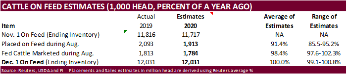
commitments of traders weekly report on positions for various U.S. futures and options, 3:30pm - U.S.
Cattle on Feed
Source:
Bloomberg and FI
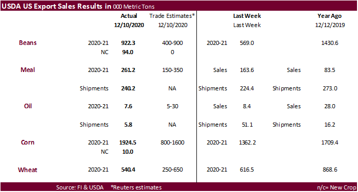
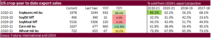
USDA
Export Sales
·
USDA export sales for soybeans were 922,300 tons, above expectations, and included 919,700 tons for China but 791,000 tons of that was switched from unknown. Mexico, Vietnam and Indonesia were good
buyers for the week ending Dec 10.
·
USDA soybean meal export sales were 261,200 tons and shipments at 240,200 tons.
·
USDA soybean oil sales of 7,600 tons were at the low end of expectations and shipments were only 5,800 tons.
- USDA
corn export sales of 1.926 million tons were above expectations and included Mexico (714,900 MT), unknown destinations (402,300 MT), and China (231,800 MT with 70,000 MT switched from unknown destinations). Sorghum sales were 325,400 tons and included China
(325,900 MT, including decreases of 61,500 MT and 70,700 late). There were 68,000 tons of sorghum reported for new-crop. Pork sales were a large 39,900 tons but China and Hong Kong accounted for a small amount.
- All
wheat USDA export sales were 540,400 tons, within expectations. China took a cargo.
HIS
Markit US update via trade sources:
2020
U.S. corn yield 174.1, down from 175.7 in Nov and compares to 175.8 USDA
2020
U.S. corn production 14.404 billion bushels, down 103 from USDA.
2020
U.S. soybean yield 50.4, down from 50.8 in Nov and compares to 50.7 USDA
2020
U.S. soybean production 4.146 billion bushels, down 24 from USDA
2021
US acreage:
Corn:
91.2, down 583,000 from Nov
Beans:
89.4, up 370,000 from Nov
All
Wheat: 45.4, down 565,000 from Nov
Cotton:
13.1, up 40,000 from Nov
US
Initial Jobless Claims Dec 12: 885K (est 815K; prevR 862K; prev 853K)
US
Continuing Claims Dec 5: 5508K (est 5700K; prevR 5781K; prev 5757K)
US
Housing Starts Nov: 1547K (est 1535K; prevR 1528K; prev 1530K)
US
Housing Starts (M/M) Nov: 1.2% (est 0.3%; prevR 6.3%; prev 4.9%)
US
Building Permits Nov: 1639K (est 1560K; prevR 1544K; prev 1545K)
US
Building Permits (M/M) Nov: 6.2% (est 1.0%; prevR -0.1%; prev 0.0%)
US
Philadelphia Fed Business Outlook Dec: 11.1 (est 20.0; prev 26.3)
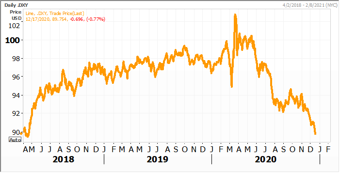
US
Dollar Index
Source:
Reuters and FI
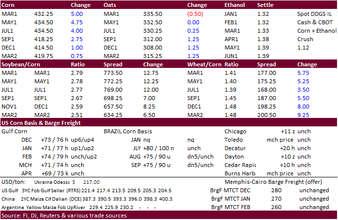
Corn.
-
CBOT
March corn started lower but turned higher from strength in soybean, very good USDA export sales, a sharply lower USD (down 70 as of 1:45 pm CT), higher WTI crude oil and strength in the US equity markets. US stimulus talks are progressing, and this was pressuring
the dollar index. Grains were limited on a couple developments. The decline in US ethanol production reported yesterday was seen bearish for US domestic demand. On the feed demand side, end users have been stepping up purchases of US soybean meal for animal
use, making some think corn for feed use during the Sep-Nov period will end up lower than a year ago. Our tentative US corn for feed estimate for Q1 2020-21 crop-year is down 8 percent from year ago.
-
The
European Commission raised its estimate of 2020-21 usable EU corn production to 62.5 million tons from 60.2 million projected in November. And they lowered its import forecast for 2020-21 EU corn to 19 million tons from 21 million.
- USDA
corn export sales of 1.926 million tons were above expectations and included Mexico (714,900 MT), unknown destinations (402,300 MT), and China (231,800 MT with 70,000 MT switched from unknown destinations). Sorghum sales were 325,400 tons and included China
(325,900 MT, including decreases of 61,500 MT and 70,700 late). There were 68,000 tons of sorghum reported for new-crop. Pork sales were a large 39,900 tons but China and Hong Kong accounted for a small amount.
- BAGE
reported Argentina corn planting progress at 55 percent complete, up 8 points from the previous week and compares to 63 percent year ago.
-
China
will offer 103,431 tons of corn from states reserves stored in the northeast region on Tuesday from the 2014 and 2015 harvests.
-
China’s
Heilongjiang local government sold 88.5% of 2015 corn out of reserves from 714,516 tons offered.
-
China
sold 16,000 tons out of 20,000 tons of pork from reserves. The Chinese government expects hog numbers to rebound back to pre‐ASF levels by mid‐2021.
US
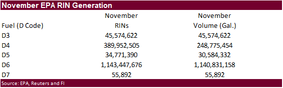
EPA
reported November RIN generation ethanol (D6) blending credits at 1.14 billion, down from 1.15 billion in October.
Corn
Export Developments
- None
reported
Today
in Energy: U.S. jet fuel consumption during the week of Thanksgiving was about half of last year’s
https://www.eia.gov/todayinenergy/detail.php?id=46316&src=email
Updated
11/30/20
March
corn is seen
trading in a $4.15 and $4.40 range.