FOMC
Benchmark Interest Rate Unchanged; Target Range Stands At 0.00% – 0.25%
–
Interest Rate On Excess Reserves Unchanged At 0.10%
sees 0% rates thru 2023
Choppy
trade but nearby soybean meal proved resilient to on and off pressure in soybeans and soybean oil amid Argentina strike concerns. Corn bounced higher possibly on unwinding of recent soybean/corn spreading and wheat fell on lack of US export developments.
![]()
EARLY
MORNING WEATHER UPDATE
- Argentina’s
rain forecast for Friday into Saturday was notably reduced by the GFS model run overnight, but that was a badly needed change - The
European model run was also a little lighter on rainfall, but our official forecast has not changed much today because we did not buy into the GFS solution Tuesday - Rainfall
of 0.40 to 1.50 inches is expected to be most likely with a few locations to get up to 2.25 inches
- All
of the precipitation will be welcome, but with the following seven days expected to be dry there is not going to be a lasting break from the dryness and concern over returning stress sooner than the market was expecting following some forecasts released Tuesday
has the market a little bullish today - Argentina
is not on a path to see huge improvements in weather and its production potential is certainly not set in stone. Early season crop losses have already occurred, but the bulk of summer crops are still being planted and their fate will be largely determined
by weather in January and February. La Nina will not go away fast enough to allow good rainfall into Argentina on a more routine basis and that will keep the worry over crop conditions running high for at least a few more weeks, despite periodic bouts of erratic
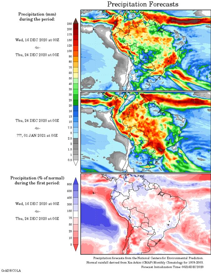
rain. - Brazil’s
weather outlook has not changed much - There
is still some worry over erratic rainfall advertised in Mato Grosso, northern Mato Grosso do Sul, Bolivia, southern Goias and areas northeast into Piaui and Bahia today - These
areas will be driest through the weekend, but next week’s rain is still expected to be erratic and lighter than desired in some areas and the situation will still be closely monitored - However,
from a soil moisture perspective many areas in Brazil will continue to experience a good environment for improved crop development - Interior
southern and center south Brazil crop areas are still expecting sufficient rain to support long term crop development - Southern
Paraguay and southwestern Parana along with a few far southern Mato Grosso do Sul locations should be wettest in the coming several days - After
that, southern Minas Gerais and northeastern Sao Paulo will be wettest - The
greatest rain advertised for Brazil’s center west and northeastern crop areas evolves next week especially mid- to late week - Center
west Brazil will continue to be a little warm over the next several days while rainfall is most restricted and light.
- Indonesia
and Malaysia rainfall recently has become a little lackluster and a boost in precipitation will eventually be needed - No
area is dry enough to pose a threat to short rooted crops, but greater volumes of rain would be welcome - The
pattern of erratic rainfall that is a little lighter than usual may prevail through the end of this month - U.S.
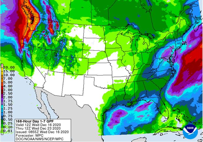
weather Tuesday brought more snow to the central Plains and into a part of the lower Midwest overnight while rain evolved in the Delta and was advancing northeastward today - Snow
accumulations of 1 to 5 inches occurred in parts of hard red winter wheat country - Local
accumulations to 8 inches occurred in northwestern Kansas while up to 10 inches occurred near Woodward, Oklahoma (located in the northwest part of that state) - Moisture
totals were not more than 0.23 inch through dawn today – at least officially, although Doppler radar suggested a few areas in west-central and northwestern Oklahoma received up to 0.40 inch - Snow
accumulations in the lower Midwest were mostly 1 to 2 inches, but portions of central Indiana received 2 to 4 inches - Light
rain fell in the middle and lower Delta and from there into the interior southeastern states and moisture totals through dawn today varied from 0.05 to 0.75 inch, although much of the precipitation had been light - Temperatures
were quite cold again this morning in the U.S. Plains - Lows
in the teens occurred in West Texas and in the negative and positive single digits across eastern Colorado and far western Kansas - No
crop threatening conditions were suspected - U.S.
weather is expected to be tranquil for a while - Today’s
storm in the lower eastern Midwest, Delta and southeast will shift to the middle and northern Atlantic Coastal States today and early Thursday - Heavy
snow will fall from the mountains of Virginia through central and eastern Pennsylvania to southern New York and parts of southern New England - Accumulations
of one to two feet will occur in central Pennsylvania while 4 to 10 inches occurs around that area - Lighter
snowfall will occur in the eastern Midwest with 1 to 2 inches expected - Another
frontal system moving through the Midwest this weekend will produce some additional snow and rain with some rain in the Delta as well - One
more storm system will move through the Midwest in the middle to latter part of next week and it too will impact the southeastern states with some more precipitation as well - Temperatures
will be warmer than usual in the north-central states in the coming week and then trend a little cooler during the last week of this month - No
extreme cold is expected, but temperatures will come closer to normal - U.S.
northern Plains moisture is expected to continue limited over the next ten days - U.S.
southwestern Plains will fail to get much “meaningful” moisture in the next ten days - Far
southwestern U.S. crop areas will remain drier biased over the next two weeks - U.S.
Delta and southeastern states will remain plenty moist over the next two weeks especially in the southeastern states - Eastern
Australia’s recent precipitation induced some flooding along the upper New South Wales and lower Queensland coasts
- Some
damage to sugarcane may have occurred, but other crops were not seriously impacted - Australia’s
rain in the coming ten days will advance a little farther inland, but “western” cotton and sorghum areas are not likely to get much precipitation - Central
and eastern cotton and sorghum areas of Queensland and northeastern New South Wales will get some much needed rain to help improve planting prospects for sorghum and late season cotton - Far
southern India will receive additional rain through the weekend and then drier biased conditions are likely - Sporadic
showers will occur in other central, eastern and far northern crop areas, but most of them will not produce enough moisture to change soil or crop conditions - South
Africa will continue to receive erratic rainfall over the next two weeks resulting in good soil moisture in the central and east eventually, but some greater precipitation will be needed
- Rainfall
through this weekend will be erratic and light favoring the central and east, but a bigger boost in rainfall might be needed - Western
crop areas will get needed rain during mid- to late-week next week and that will eventually spread to the east improving soil moisture at that time - Northern
and central China winter crops will not experience much precipitation for a while and crops will remain dormant - Southern
China will experience precipitation most often during the next two weeks with next week wettest - Some
disruption to sugarcane harvest might occur - Southern
Vietnam, Thailand and Cambodia will trend drier over the coming week after recent rain
- The
recent moisture delayed harvest progress for some crops, but no serious crop quality changes are likely - Winter
crops benefitted from the expected moisture - Routinely
occurring precipitation is expected in Philippines, Indonesia and Malaysia over the next two weeks - A
tropical disturbance will move through much of the nation Thursday through Monday producing some significant rainfall and possible flooding - Another
tropical cyclone may form in the South China Sea Sunday into Monday and drift toward southern coastal areas of Vietnam while weakening later next week - Indonesia
and Malaysia rainfall will continue erratic and lighter than usual - Recent
weeks of precipitation has been lighter than usual and more sporadic leaving some areas with less than usual moisture, but soil conditions are still rated mostly good - A
boost in rainfall will have to occur soon, but may not take place for a while - Isolated
to scattered showers will occur at times, however - Russia’s
Southern Region had eastern Ukraine will receive some rain and snow over the next few days - Moisture
totals are unlikely to be great enough to seriously change soil moisture and crops are dormant and unlikely to respond - Moisture
totals will vary up to 0.20 inch - Some
follow up precipitation is “possible” next week and again later this month, but resulting precipitation in each event will be limited - The
bottom line remains one of concern, but World Weather, Inc. believes there will be some increase in soil moisture from periodic precipitation this winter and spring to give crops a chance to improve during the spring. Some increase in snow cover in northern
parts of the production region will help protect crops against any harsh winter weather that comes along - Temperatures
will be a little warmer than usual over the next two weeks - Europe
precipitation during the coming week will be greatest in France, the U.K., northwestern parts of Spain, Portugal and a few other areas in the North Sea region - Some
local flooding is possible in many of these areas - Net
drying is expected in the Baltic Plain and areas south into the lower Danube River Basin this week - Temperatures
will be warmer than usual - North
Africa will receive sporadic rain for a while except in coastal areas of northeastern Algeria - Morocco
remains in need of significant rain and should get some today, although it will be light - Greater
rain may continue to elude the region for the next couple of weeks, despite a few light showers - Southern
Oscillation Index was at +11.67 today and it will remain strongly positive for a while - Tropical
Cyclone Zazu and Tropical Cyclone Yasa in the southwestern Pacific Ocean will not impact any major agricultural area, but the storm systems will move through some of the smaller Pacific Islands this week - Zazu
was dissipating today, but Yasa was a powerful storm that may impact a part of the Fiji Islands over the next few days - Mexico
precipitation will be quite limited over the coming week - Portions
of Central America will continue to receive erratic rainfall over the next couple of weeks, but the intensity and frequency will be low enough to support some farming activity - Costa
Rica and Caribbean coastal areas of both Nicaragua and Honduras will be wettest this workweek
- West-central
Africa will experience unusually great rainfall this week stalling harvest progress and raising a little worry over cocoa and coffee conditions - Some
rain will also reach into southwestern Ghana and Senegal - Drier
weather is needed; this is normally the start of the dry season - East-central
Africa rain will be erratic and light in Ethiopia, Kenya and Uganda while rainfall will be greatest over Tanzania this week - Some
rain will develop this weekend into next week in Ethiopia, Kenya and it may increase in Uganda - New
Zealand will be drier than usual this week from northern and central parts of South Island to North Island while rain falls to the southwest - Temperatures
will be near to above average
Source:
World Weather Inc. and FI
Thursday,
Dec. 17:
- USDA
weekly crop net-export sales for corn, soybeans, wheat, cotton, pork, beef, 8:30am - USDA
Total Milk Production, 3pm - Port
of Rouen data on French grain exports - Conab’s
estimate for 2020 Brazil coffee crop - Poland
publishes crop output figures for 2020
Friday,
Dec. 18:
- ICE
Futures Europe weekly commitments of traders report, 1:30pm (6:30pm London) - CFTC
commitments of traders weekly report on positions for various U.S. futures and options, 3:30pm - U.S.
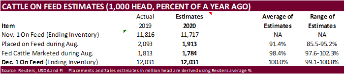
Cattle on Feed
Source:
Bloomberg and FI
FOMC
Benchmark Interest Rate Unchanged; Target Range Stands At 0.00% – 0.25%
–
Interest Rate On Excess Reserves Unchanged At 0.10%
sees 0% rates thru 2023
US
DoE Crude Oil Inventories (W/W) 11-Dec: -3135K (est -2200K; prev 15189K)
–
Distillate Inventories (W/W): 167K (est 850K; prev 5222K)
–
Cushing OK Crude Inventories (W/W): 198K (prev -1364K)
–
Gasoline Inventories (W/W): 1020K (est 1874K; prev 4221K)
–
Refinery Utilization: -0.80% (est 0.50%; prev 1.70%)
US
Retail Sales Advance (M/M) Nov: -1.1% (est -0.3%; prevR -0.1%; prev 0.3%)
US
Retail Sales Ex-Auto (M/M) Nov: -0.9% (est 0.1%; prevR -0.1%; prev – 0.2%)
US
Retail Sales Ex-Auto, Gas Nov: -0.8% (est 0.1%; prevR -0.1%; prev 0.2%)
US
Retail Sales Control Group Nov: -0.5% (est 0.2%; prevR -0.1%; prev 0.1%)
Canadian
CPI NSA (M/M) Nov: 0.1% (est 0.0%; prev 0.4%)
Canadian
CPI (Y/Y) Nov: 1.0% (est 0.8%; prev 0.7%)
Canadian
CPI Core – Median (Y/Y) Nov: 1.9% (est 1.9%; prev 1.9%)
Canadian
CPI Core – Common (Y/Y) Nov: 1.5% (est 1.6%; prev 1.6%)
Canadian
CPI Core – Trim (Y/Y) Nov: 1.7% (est 1.8%; prev 1.8%)
Canadian
International Securities Transactions Oct: 6.92B (prev 4.46B)
Canadian
Wholesale Trade Sales (M/M) Oct: 1.0% (est 0.7%; prev 0.9%)
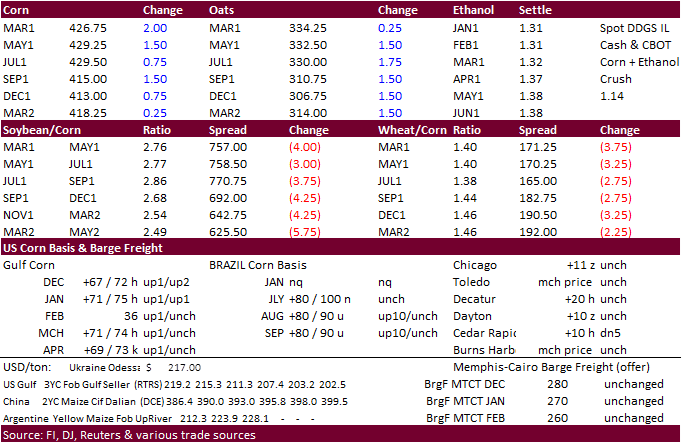
Corn.
-
CBOT
March corn traded
two-sided with March ending 2.50 cents higher and May up 2.0 cents. Lack of fresh news kept corn from rallying early but as soybeans paired gains by mid-morning, unwinding of recent soybean/corn spreading underpinned corn futures.
-
Funds
bought an estimated net 8,000 corn contracts. -
Bloomberg
reported China is close to securing a trade deal with China to supply corn. Talks are in advanced stages and many of the technical issues have been resolved.
-
China
corn futures fell to their lowest level since September 30. -
China’s
Heilongjiang plans to offer 714,516 tons of 2015 corn from state reserves on Thursday. -
China
will offer to sell 20,000 tons of pork sales from reserves on Thursday. The Chinese government expects hog numbers to rebound back to pre‐ASF levels by mid‐2021. -
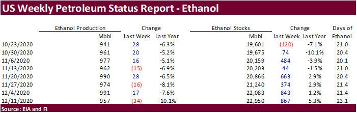
EIA
weekly US ethanol production for the week ending 12/11 was reported at 957,000 barrels per day, down 34,000 barrels from the previous week, bearish in our opinion for US corn futures. Weekly ethanol stocks were up a large 867,000 barrels to 22.950 million
barrels. A Bloomberg poll looked for weekly US ethanol production to be down 9,000 from the previous week and stocks up to 320,000 barrels. Weekly ethanol production slipped to its lowest level since mid-November. September to date ethanol production is
running 6.3 percent below the same period year ago. Ethanol stocks are highest since May 22. Ethanol blended into gasoline were 7.94 million barrels, representing 89.3 percent of blend rate into finished motor gasoline.
Corn
Export Developments
- None
reported
Updated
11/30/20
March
corn is seen
trading in a $4.15 and $4.40 range.