PDF Attached
No
24-hour USDA sales this morning but late session rumors of Chinese buying of corn and wheat underpinned grain futures. Soybeans fell led by weakness in soybean meal.
![]()
Weather
MOST
IMPORTANT WEATHER IN THE WORLD
- Today’s
GFS 00z model run produced a significant storm in the central U.S. impacting hard red winter wheat production areas Dec. 11-12, but that advertised storm will NOT verify. The 06z model run has already corrected back to a more limited precipitation event,
although some moisture may occur - World
Weather, Inc. still believes that there will be some periodic weather events in the central and southwestern Plains this month, but the amount of moisture resulting will continue below average leaving the region’s moisture deficits in place - Seasonably
mild to cool temperatures will help conserve whatever moisture does occur helping to leave at least a little more moisture in the soil at the end of this month than there is today, but the need for greater moisture will remain - Southern
Russia and other areas near the Black Sea will also experience a little more precipitation in December than in November and there will be “some” increase in soil moisture for the region and a little snow cover at times, too; however, moisture deficits will
remain in at least a part of this region as well as in the west-central and southwestern U.S. Plains - Argentina
rainfall overnight was greatest in central and interior northern Cordoba and a few central Santa Fe locations with amounts of 0.20 to 0.88 inch common and a few amounts as great as 1.25 inches
- Southern
Cordoba and far northern Cordoba as well as most other areas in the nation were left mostly dry - The
moisture was welcome and beneficial to “some” important summer crop areas - That
part of Argentina was missed by last weekend’s greater rainfall that impacted northeastern and east-central parts of the nation which has improved many crops in the nation – temporarily - Argentina’s
rain will be quick to advance northeast today impacting northern and central Santa Fe, northern Entre Rios, Corrientes, eastern Chaco and eastern Formosa bringing more moisture to areas that have become rather moist already because of last weekend’s rain - Moisture
totals will vary from 0.50 to 1.50 inches with a few amounts of 2.00 inches or more - Argentina
weather will be one of net drying Thursday through next Wednesday except in the far northwest of the nation where rain is expected late Monday into Tuesday before moving to Paraguay Wednesday, Dec. 9. - Portions
of Santiago del Estero, western Chaco, northwestern Formosa and southeastern Salta may be wettest with 0.50 to 1.75 inches possible and locally more - Drying
outside of the northwest during the coming week will lead to crop moisture stress for some areas in the south where recent rain has missed - Favorable
subsoil moisture in Buenos Aires will carry crops through the coming week of drying, but rain will be needed soon thereafter - Southern
Argentina “may” receive some rain Dec. 11-12, but amounts may be light and the benefit will be short-lived - That
rain event will impact other areas in the nation Dec. 12-14 favoring the north - Argentina’s
bottom line for the next couple of weeks will be favorable for crops in the north and especially the northeast. However, soil moisture may be a little low in southern parts of the nation for a while, including southern Cordoba, La Pampa and parts of Buenos
Aires and southern most Santa Fe. It is important to noted, though, that subsoil moisture in central and eastern Buenos Aires is still rated favorably. The drier bias in the south is not all bad – winter crops that are filling, maturing and being harvested
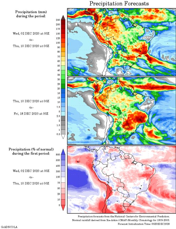
will all benefit. - Brazil
weather is expected to improve over the coming two weeks except in the northeast where net drying is expected in parts of Bahia and possibly portions of Piaui
- Rain
in most other areas will be sufficient to support crops favorably - Portions
of Minas Gerais may become too wet as time moves along with multiple inches of rain expected that could lead to local flooding in time (probably next week) - Parana
may receive some moderate to locally heavy rainfall along with southeastern Paraguay and a few immediate neighboring areas by Sunday - Moisture
totals of 2.00 to 6.00 inches will occur in these areas with some model data suggesting locally more - Mato
Grosso and Goias rainfall will occur periodically and a bit more erratically than some other areas, but all of both states will be impacted eventually - Rio
Grande do Sul rainfall will be greatest today with a more sporadic and light distribution of rain after that for much of the coming ten days leaving the state with returning dryness in time - Brazil’s
bottom line should prove to be mostly good, but keep an eye on Bahia, Piaui and Rio Grande do Sul rainfall over the next couple of weeks. Those areas have the greatest potential of drying down. Conditions supporting improved monsoonal rainfall in late December
and January seem to be coming together, although much of this week’s rainfall cannot be attributed to improved monsoonal activity. Crop conditions should improve for the majority of center west and center south production areas over the next ten days.
- Eastern
Australia rain potentials will slowly be improving over the next two weeks with dryland crop areas of Queensland and New South Wales getting some badly needed rain during the second half of next week and into the following weekend - The
significance of this change has not been fully determined, but relief from recent excessive heat and dryness is probable - Temperatures
will not be nearly as oppressively hot during the next ten days, but warmer than usual conditions will prevail in Queensland until significant rain evolves - Good
harvest weather is expected in southern Australia around periods of light rainfall.
- South
Africa rainfall will scatter across the nation over the next ten days benefiting most summer crop areas and improving early season emergence and growth eventually - Portions
of the nation are still a little too dry for optimum crop development, but the rain coming should bring improvement
- Free
State, western North West and eastern Northern Cape are among the driest areas - Tamil
Nadu, India and northern Sri Lanka will be impacted by Tropical Cyclone Burevi - The
storm will move across northern Sri Lanka today and then to far southern Tamil Nadu and southern Kerala Thursday - The
storm will produce heavy rain in both regions resulting in some flooding and minor amount of damage to personal property and agriculture - Rainfall
of 3.00 to 12.00 inches will occur in northern Sri Lanka while 2.00 to 5.00 inches occur in southern India through Friday - Additional
waves of rain will continue far southern India and Sri Lanka through early next week, although amounts will be much lighter - Sugarcane,
rice and some cotton will be most impacted by the storm - Other
areas in India will experience good weather for crop maturation and harvest progress - U.S.
weather was mostly dry Tuesday, although some moisture occurred in the northwestern Plains and from the northeastern corner of the Midwest into New England - No
threatening cold occurred in Florida citrus areas this morning - U.S.
weather through the weekend presents one storm system - Rain
and snow evolve in southern and western Kansas, the Oklahoma and northeastern Texas Panhandles, southeastern Colorado and in most of Oklahoma today and early Thursday - Moisture
totals will vary from 0.05 to 0.50 inch with a few totals to 0.70 inch - Some
heavy snow is expected with 2 to 5 inches common from southeastern Colorado to southwestern Kansas and northern parts of the Texas Panhandle while varying locally up to 10 inches favoring a few counties from northwestern Oklahoma into the eastern Oklahoma
Panhandle and few Kansas locations near the Oklahoma border - Rain
from this event will also occur in eastern Texas, western Arkansas and western Louisiana by Thursday morning - The
southern Plains storm will diminish while drifting into the Delta Thursday and then intensify in Tennessee and Kentucky Friday before moving northeast through southern New England Saturday - Portions
of the southeastern states will also get rain from this event - Moisture
totals will be less than 0.60 inch in the Delta and vary from 0.20 to 0.75 inch in the southeastern states while eastern Kentucky, eastern Tennessee and areas northeast to New Jersey receive 0.75 to 1.25 inches of moisture - Precipitation
elsewhere in the U.S. will not be very great through the weekend, although some rain and mountain snow will develop in Washington and Oregon - U.S.
weather next week will bring another storm from the southwestern states into the southern Plains during mid-week and then northeast to the Great Lakes region late in the week and into the following weekend - A
couple of follow up storm systems will impact the Delta, lower eastern Midwest and interior southeastern states in the second weekend of the outlook into Dec. 15.
- Other
areas will not likely see much precipitation - U.S.
temperatures will be quite warm in the north-central states and New England in this first week of the outlook and then cooling is expected in many areas in the central and northwestern parts of the nation in the following week - Snow
cover in CIS winter crop areas continues restricted in some areas, but there has been no threatening cold in recent days and none was expected through the next ten days - Bitter
cold will be confined to the eastern New Lands and Kazakhstan - Brief
periods of light snow and rain will impact the western CIS over the next ten days; not much improvement in soil moisture is expected in the drier areas leaving parts of Ukraine, Russia’s Southern Region and Kazakhstan still in need of greater moisture - Temperatures
will be close to normal west of the Ural Mountains and below average to the east - Europe
precipitation is expected to be erratic over the next ten days to two weeks with sufficient amounts in some areas to bolster soil moisture for use in the spring - Italy,
the eastern Adriatic Sea region, parts of the Iberian Peninsula France and the U.K. will be wettest - Soil
moisture is still favorable in much of the continent - Temperatures
will be seasonable with a cool bias in the west and a warm bias in the east - North
Africa rainfall will be greatest and most frequent in the coming week to ten days in northern Algeria, although some beneficial moisture will also impact northeastern Morocco and a few northern areas of Tunisia - Greater
rain is needed in Morocco and northwestern Algeria to improve planting conditions for wheat and barley - China
weather over the next two weeks will include restricted amounts of precipitation and temperatures will be near to slightly below average except in the far northeast where they will be a little warmer biased - East-central
parts of the nation will be wettest keeping some southern wheat and rapeseed areas plenty moist - Indonesia,
Malaysia and Philippines weather during the next two weeks will be routinely moist with frequent showers and thunderstorms supporting long term crop development - Interior
parts of mainland Southeastern Asia will be mostly dry over the next ten days - Some
frequent rain will occur along the Vietnam coast due to a strong northeast monsoon flow pattern - Local
flooding may occur, but mostly next week - Southern
Oscillation Index was +8.74 today; the index will rise the remainder of this week and into the weekend - Mexico
precipitation will be quite limited over the coming week favoring summer crop maturation - Southern
areas will be wettest and only light rainfall from scattered showers will result - Portions
of Central America will continue to receive periodic rainfall over the next couple of weeks, but the intensity and frequency of rain will be low in the north - Costa
Rica and Panama will be wettest along with southern Nicaragua this workweek
·
West-central Africa will experience erratic rain through the next ten days favoring crop areas close to the coast
·
East-central Africa rain will be erratic and light over the coming week
·
New Zealand rainfall will be erratically distributed over the next ten days benefiting most areas
- Amounts
will be near to above average along the west coast of South Island and in a few southern areas of North Island in this first week of the outlook and below average elsewhere - Temperatures
will be a little cooler than usual
Source:
World Weather Inc. and FI
Thursday,
Dec. 3:
- USDA
weekly crop net-export sales for corn, soybeans, wheat, cotton, pork, beef, 8:30am - FAO
World Food Price Index - Port
of Rouen data on French grain exports - ANZ
Commodity Price - Indonesian
palm oil conference, day 2 - International
Coffee Conference, day 3 - Canada
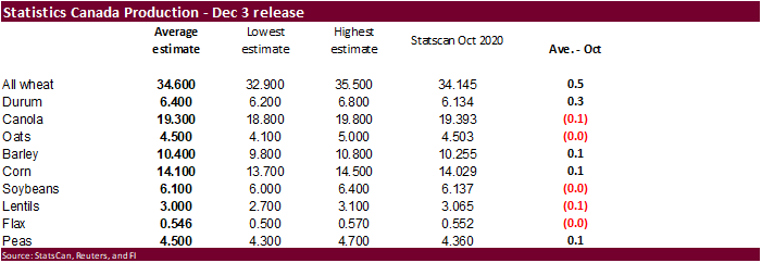
Statcan wheat, durum, canola, barley and soybean production
Friday,
Dec. 4:
- ICE
Futures Europe weekly commitments of traders report, 1:30pm (6:30pm London) - CFTC
commitments of traders weekly report on positions for various U.S. futures and options, 3:30pm - China’s
CNGOIC to publish monthly soy and corn reports - FranceAgriMer
weekly update on crop conditions
Source:
Bloomberg and FI
USD
Index – Monthly
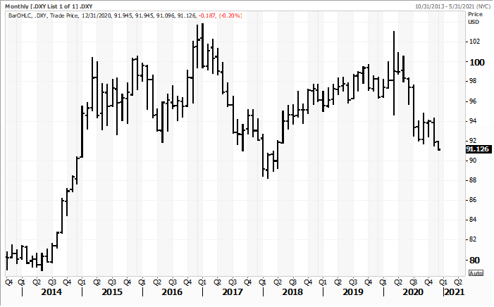
Source:
Reuters & FI
US
ADP National Employment (Nov): 307K (est 410K, prev 365K)
Canada
Labour Productivity Rate (Q3): -10.3% (PrevR 10.5%)
OPEC
Crude Output Rose 530,000 Barrels Per Day in Nov.
US
DoE Crude Oil Inventories (W/W) 27-Nov: -679K (est -2358K; prev -754K)
–
Distillate Inventories: 3228K (est -209K; prev -1441K)
–
Cushing OK Crude Inventories: -317K (prev -1721K)
–
Gasoline Inventories: 3491K (est 2386K; prev 2180K)
–
Refinery Utilization: -0.50% (est 0.90%; prev 1.30%)
Corn.
-
CBOT
corn started lower but rebounded on speculation China bought US corn for Q2/Q3 shipment. Prices were primarily lower earlier on a wet weather forecast for South America over the next two weeks. Bottom picking in wheat started to pair losses in the corn market
and technical buying eventually took over. Lower soybeans limited losses. March corn traded below a strong support level of $4.21 overnight but ended 3.0 cents higher at $4.2375. Technicals still look bearish for corn, in our opinion. However, a confirmation
of US corn sales Thursday morning may propel futures higher. -
Funds
bought an estimated net 13,000 corn contracts after selling 43,000 over the previous two days.
-
There
was an increase in commercial demand for corn and wheat today. -
Late
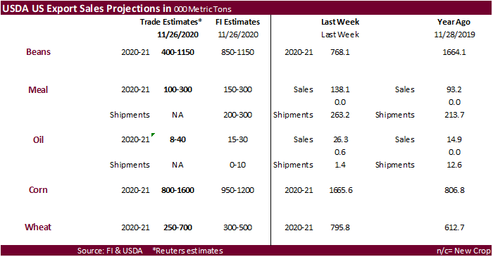
in the session we heard 1-2 million tons of corn was sold for April through June shipment. 24-hour sales will be widely watched Thursday morning. Trade estimates for USDA export sales range from 800,000 to 1,600,000 tons. During the trade we heard corn
sales could be massive for that week. Note USDA reported two 24-hour corn sales announcements for the week ending 11/26.
-
The
USD was about 31 points lower and WTI crude was $0.57 higher, at the time this was written.
-
Brazil
domestic corn prices continues to weaken even though a couple production estimates for this year’s crop were trimmed this week and soybean replanting concerns (MG to replant more than 5 percent of the soybean crop).
-
The
USDA weekly Broiler Report showed eggs set in the US down 2 percent and chicks placed down 2 percent. Cumulative placements from the week ending January 4, 2020 through November 28, 2020 for the United States were 8.85 billion. Cumulative placements were
down 1 percent from the same period a year earlier. -
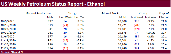
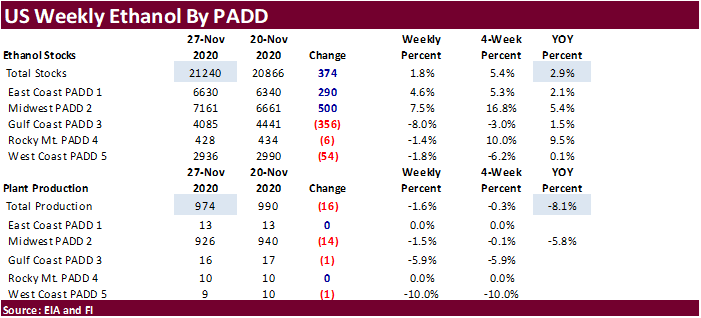
US
EIA weekly ethanol production declined 16,000 barrels per day to 974,000, near what the trade expected, and stocks increased 374,000 barrels, about what the trade also expected. Note production is off from 990,000 posted last week, which hit highest level
since when energy demand destruction significantly increased back in late March 2020. September 2020 to date ethanol production is off 5.9 percent from the same period a year earlier. Ethanol stocks have seen a decent build since the third week of October
and is 2.9 percent higher than this time year ago.
Corn
Export Developments
- South
Korea’s FLC bought 65,000 tons of optional origin corn at $239.90/ton for arrival around June 15.
- Algeria
seeks 35,000 tons of optional origin corn on Thursday for shipment by Jan 5.
Updated
11/30/20
March
corn is seen
trading in a $4.15 and $4.40 range.