Soybeans
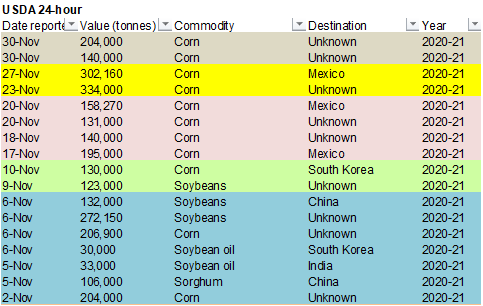
and corn saw a lower trade on improving SA weather while wheat traded lower after talk Russian may relax on grain export restrictions. Australian harvest pressure should also be noted. Corn saw limited losses after USDA reported 140k corn to unknown and
204k corn received in the reporting period to unknown. Export inspections were within expectations for all three major commodities. The US dollar index hit its lowest level since April 2018.
World
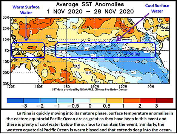
Weather Inc. noted La Nina is just a few weeks away from its peak but will stick around through the second quarter of 2021.
Source:
World Weather Inc.
EARLY
MORNING WEATHER UPDATE
CHANGES
OVERNIGHT
- U.S.
west-central high Plains experienced unexpected bitter cold temperatures overnight – a sign of drought - Temperatures
fell to -2 Fahrenheit at Medicine Creek, Nebraska (located in the far southwest of the state), -1 at Scott City, Kansas and -3 near Eads, Colorado.
- Most
other readings were in the positive single digits and teens - Some
crop damage might have occurred due to snow free conditions and the fact that crops were moving into dormancy - World
Weather, Inc. does not expected damage outside of a small pocket or two - The
impact on 2021 production will be minimal - Rain
was increased in a part of eastern Queensland for next week - This
change has been expected because of the rising Southern Oscillation Index, but the timing and specific amounts of rain advertised may change in additional model runs - The
theme for increasing precipitation next week is likely a good one - Rain
in far southern India will begin to increase late Tuesday and especially Wednesday into Friday as a tropical disturbance impacts the region after moving through northeastern Sri Lanka Tuesday into Wednesday - Little
damage is expected, although Sri Lanka will experience some flooding and some moderate wind speeds in sugarcane, rice and other crop areas - Eastern
China’s weather is a little wetter for next week, according to the GFS model run, but the boost was likely overdone. - The
European model solution and older GFS model runs are more likely to verify keeping precipitation limited to the east-central China over the coming week with much of the precipitation staying light - Western
Europe is wetter in the latest GFS model run – some of the precipitation was overdone; however, wetter conditions are likely to evolve this weekend into next week
MOST
IMPORTANT WEATHER AROUND THE WORLD
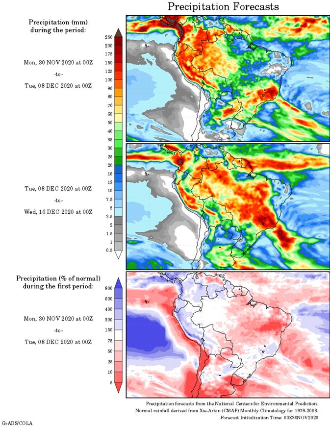
- Argentina
rain during the weekend was greatest from east-central Santa Fe and Entre Rios into central and southern Corrientes, Chaco and northern Uruguay
- Rainfall
ranged from 1.10 to 3.54 inches - Lighter
rain fell elsewhere with 0.57 to 1.14 inches from northeastern La Pampa to southwestern Santa and southeastern Cordoba.
- Rainfall
in the remainder of the nation was mostly less than 0.50 inch which resulted in net drying - Highest
afternoon temperatures were in the 80s and 90s Fahrenheit - Argentina
will experience additional showers and thunderstorms through Wednesday to early Thursday morning from San Luis through Cordoba to Formosa and Corrientes - Rainfall
of 2.00 to more than 5.00 inches will result with northern Santa Fe, northwestern Corrientes and eastern Chaco wettest - Some
flooding will be possible since the ground will already be saturated from the weekend precipitation - Rainfall
of 0.05 to 0.75 inch will occur elsewhere with a few totals to 2.00 inches in the far northwest - Southern
and a few east-central crop areas will be dry or mostly dry - Thursday
through Monday, Dec. 7 will be mostly dry, although a few isolated showers will occur periodically with not much resulting rainfall of significance - Scattered
showers and thunderstorms will resume again Dec. 8 and last through Dec. 12 before net drying occurs once again - Daily
rainfall during this period of time will vary from 0.05 to 0.65 inch with a few local totals over 1.00 inch - Temperatures
will be seasonable during the coming week and slightly warmer than usual in the following week - Despite
the timeliness of rainfall in Argentina over the next two weeks, moisture deficits will not be completely eliminated from key grain and oilseed production areas. Producers will be hoping that enough rain will fall to keep crops viable until more substantial
rain arrives - Brazil
rainfall during the weekend was quite limited - Central
Parana through Rio Grande do Sul to northern Uruguay was wettest with amounts of 0.60 to 2.00 inches resulting - Local
totals over 2.00 inches occurred in far western parts of Rio Grande do Sul - Net
drying occurred elsewhere in Brazil, despite a few showers of light intensity - Temperatures
were near to above average with highest afternoon temperatures Friday and Saturday in the 80s and 90s with lows in the 60s and 70s - Brazil’s
outlook remains as it was Friday and Sunday with slowly improving rainfall across the nation this week; however, southern Mato Grosso and northern Mato Grosso through Bahia, Piaui and Tocantins will not get much moisture through Thursday - Northeastern
areas of Brazil will stay mostly dry through the middle part of next week and then scattered showers will be possible once again - Rain
totals by the end of next week will have ranged from 3.00-9.00 inches in eastern parts of Minas Gerais while varying from 2.50 to more than 6.00 inches in other areas of the state and immediately neighboring areas - Southern
Rio Grande de Sul, Bahia , Piaui and eastern Tocantins will be driest with 0.30 to 1.25 inches of rain resulting - A
more typical La Nina pattern is expected to dominate the week next week leaving the far south with lighter than usual rainfall and most other areas getting periodic rain - The
far northeast may struggle with dryness like that of the far south - Brazil
temperatures are expected to be a little warmer than usual in the north and a little cooler than usual in the south this week and then more seasonable next week
- Australia
experienced excessive heat Friday through Sunday and the heat will linger today before abating - Extreme
highs reached 117 degrees Fahrenheit over northeastern South Australia while varying from 100 to 113 degrees from the heart of New South Wales (west of the Great Dividing Range) into the interior of Queensland
- The
heat extended west into eastern portions of Western Australia - Weekend
precipitation was restricted with none in Queensland, sugarcane, cotton or sorghum south of the Cape York Peninsula - New
South Wales received up to 0.71 inch of moisture, but most of the state did not get enough rain to counter evaporation - Net
drying occurred elsewhere as well - Australia
weather over the next two weeks will be mixed with a few periods rain and sunshine in summer crop areas and some small grain and canola production areas
- Most
of the precipitation will be non-threatening to unharvested winter crops and only portions of the summer crop region will get meaningful rain - Some
increase in precipitation will impact far southeastern Queensland and northeastern New South Wales in the second half of this week with some follow up rain possible next week that might be more generalized - The
moisture will be welcome, but summer crop areas need greater rain to seriously bolster soil moisture for improved cotton, sorghum and other summer crop establishment and growth - Temperatures
will not be nearly as hot as the past several days, but will still be quite warm through Tuesday before becoming more seasonable - South
Africa weekend precipitation was scattered from North West to eastern parts of Eastern Cape and into western and southern Natal
- Rainfall
varied widely with some areas getting less than 0.40 inch and experiencing net drying while other areas received up to 1.81 inches - Mostly
dry weather occurred from Limpopo to Nata and in Northern Cape - Temperatures
were seasonable - The
nation still has need for more generalized rainfall of significance to bolster soil moisture for more aggressive long term crop development - India
rainfall was not very great during the weekend, although up to 0.92 inch of additional moisture occurred in the far south where Tropical Cyclone Nivar moved inland last week - Net
drying occurred elsewhere in the nation supporting good crop maturation and harvest progress - Temperatures
were mild to warm nationwide - A
weak tropical cyclone will bring rain to northern Sri Lanka and Tamil Nadu, India during mid-week this week - Rainfall
in northern Sri Lanka will range from 3.00 to more than 12.00 inches - Rainfall
in Tamil Nadu vary from 0.30 to 1.50 inches and local totals of 2.00 to 4.00 inches along the south coast - Another
tropical disturbance may stream additional rain into far southern India through the week and weekend ending next week
- No
crop damaging wind or flooding is expected - Net
drying is expected in other India locations through the next ten days - Temperatures
will be near average in the south and warmer than usual in the north - Dry
weather occurred in Russia’s Southern Region during the weekend while light rain and snow fell across northern Ukraine, Belarus and portions of Russia’s Central Region and middle Volga River Basin
- Moisture
totals were no more than 0.30 inch - Most
other areas were dry - Temperatures
were seasonably cool, but the only bitter cold occurred in Russia’s New Lands and northern Kazakhstan - No
winter wheat, barley or rye was impacted
- Snow
cover in CIS winter crop areas continues restricted in some areas, but there has been no threatening cold in recent days and none was expected through the next ten days - Bitter
cold will be confined to the eastern New Lands and Kazakhstan - Brief
periods of light snow and rain will impact the western CIS over the next ten days; not much improvement in soil moisture is expected leaving parts of Ukraine, Russia’s Southern Region and Kazakhstan still in need of greater moisture - Temperatures
will be close to normal west of the Ural Mountains and below average to the east - Precipitation
across Europe during the weekend was minimal except in the coastal areas of the Mediterranean Sea where moderate rain fell from eastern Spain to southern Italy
- Temperatures
were mild to cool - Europe
precipitation is expected to be erratic over the next ten days to two weeks with sufficient amounts in some areas to bolster soil moisture for use in the spring - Soil
moisture is still favorable in much of the continent - Temperatures
will be seasonable - North
Africa received some rain during the weekend and more will fall over the next couple of weeks in an erratic manner leaving need for greater precipitation later in December - Some
1.00 to nearly 5.00-inch rain totals occurred along the central North Coast of Algeria while 0.20 to 1.00 inch occurred elsewhere in northern Algeria - Rainfall
was more limited in other winter crop areas - U.S.
weekend weather was dry in the Midwest, central and northern Plains and most of the far west - Rain
and some wet snow fell briefly in the Texas and Oklahoma Panhandles into northern counties of West Texas - Rain
and thunderstorms occurred in other areas from the heart of Texas through the Delta to the southeastern states - Moisture
totals of 1.00 to 3.27 inches fell from the middle and upper Texas Coast through southern Louisiana to southern Alabama and parts of west-central Georgia
- Local
totals reached 5.4 inches not far from the central Texas coast - Moisture
totals in the Rolling Plains of Northern Texas ranged from 1.00 to 2.33 inches while the rest of West Texas received 0.30 inch with a few Low Plains crop areas getting up to 0.67 inch - Rainfall
in the remainder of the southeastern states varied from 0.50 to 2.17 inches; including the Carolinas, Virginia and the remainder of Georgia and northern Florida - Fieldwork
was stalled - Temperatures
were mild in much of the nation with the coolest conditions in the interior west and Rocky Mountain region - U.S.
weather will be generally dry this week in the Plains, western Corn Belt and most areas to the west excepting coastal areas of the Pacific Northwest where a little is expected - Any
precipitation that occurs in this mostly dry region will not be significant - Rain
will end in the southeastern states through the eastern Midwest and middle and North Atlantic Coast States to southeastern Canada today and early Tuesday - Additional
moisture totals will vary from 0.30 to 1.50 inches with the middle and northern Atlantic Coast region wettest
- Some
of the precipitation expected will occur Wednesday into Friday - Temperatures
will be warmer than usual in the northern Plains, Great Lakes region and northeastern states and near to below average elsewhere - No
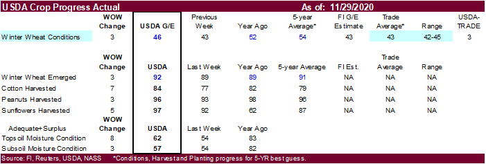
improvement in hard red winter wheat conditions are expected - West
Texas cotton harvest progress will improve this week after weekend showers - Delta
and southeastern U.S. precipitation should become less frequent and less significant over time improving the outlook - U.S.
weather next week will trend a little cooler in the northern states, Great Lakes region and northeastern states while mostly unchanged elsewhere - Precipitation
will fall in the northern Plains, Midwest, Delta and southeastern states, but mostly erratically
- Most
of the precipitation next week will occur in the second half of the week in the Pacific Northwest and then across the northern Plains in the following weekend and across the Midwest, Delta and southeastern states Dec. 12-14 - China
weather was mostly dry during the weekend with temperatures below average in the northeastern provinces and more seasonable elsewhere - China
weather over the next two weeks will include restricted amounts of precipitation and temperatures will be near to slightly below average except in the far northeast where they will be a little warmer biased - Indonesia,
Malaysia and Philippines weather during the next two weeks will be routinely moist with frequent showers and thunderstorms supporting long term crop development - Interior
parts of mainland Southeastern Asia will be mostly dry over the next ten days - Some
frequent rain will occur along the Vietnam coast due to a strong northeast monsoon flow pattern - Local
flooding may occur, but mostly next week - Southern
Oscillation Index was +9.24 today; the index will steadily rise this week - Mexico
precipitation will be quite limited over the coming week favoring summer crop maturation - Southern
areas will be wettest and only light rainfall from scattered showers will result - Portions
of Central America will continue to receive periodic rainfall over the next couple of weeks, but the intensity and frequency of rain will be low in the north - Costa
Rica and Panama will be wettest along with southern Nicaragua this workweek - A
region of disturbed tropical weather is expected to evolve this week that will be slow moving and will produce repetitive heavy rainfall in Costa Rico, Panama and southern Nicaragua
- West-central
Africa will experience erratic rain through the next ten days favoring crop areas close to the coast
- East-central
Africa rain will be erratic and light over the coming week - New
Zealand rainfall will be erratically distributed over the next ten days benefiting most areas - Amounts
will be near to above average over this first week of the outlook - Temperatures
will be a little cooler than usual
Source:
World Weather Inc. and FI
Monday,
Nov. 30:
- USDA
weekly corn, soybean, wheat export inspections, 11am - U.S.
winter wheat condition, cotton harvested, 4pm - Ivory
Coast cocoa arrivals - Malaysia’s
Nov. 1-30 palm oil export data - U.S.
agricultural prices paid, received, 3pm - CFTC
to release Commitments of Traders report, delayed from previous week due to U.S. Thanksgiving holiday; regular release schedule resumes Friday - HOLIDAY:
India
Tuesday,
Dec. 1:
- International
Coffee Conference, Vietnam, day 1 - Australia
Commodity Index - U.S.
Purdue Agriculture Sentiment - USDA
Soybean crush, DDGS production, corn for ethanol, 3pm - Virtual
summit – Resetting the Food System from Farm to Fork - CNA
Outlook for Brazil’s Agriculture in 2020, Sao Paulo - New
Zealand global dairy trade auction
Wednesday,
Dec. 2:
- EIA
U.S. weekly ethanol inventories, production, 10:30am - Virtual
Indonesian palm oil conference, day 1 - International
Coffee Conference, day 2
Thursday,
Dec. 3:
- USDA
weekly crop net-export sales for corn, soybeans, wheat, cotton, pork, beef, 8:30am - FAO
World Food Price Index - Port
of Rouen data on French grain exports - ANZ
Commodity Price - Indonesian
palm oil conference, day 2 - International
Coffee Conference, day 3 - Canada
Statcan wheat, durum, canola, barley and soybean production
Friday,
Dec. 4:
- ICE
Futures Europe weekly commitments of traders report, 1:30pm (6:30pm London) - CFTC
commitments of traders weekly report on positions for various U.S. futures and options, 3:30pm - China’s
CNGOIC to publish monthly soy and corn reports - FranceAgriMer
weekly update on crop conditions
Source:
Bloomberg and FI
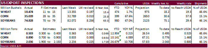
USDA
inspections versus Reuters trade range
Wheat
502,788 versus 300000-600000 range
Corn
890,033 versus 700000-1000000 range
Soybeans
2,036,484 versus 1800000-2200000 range
CFTC
– weekly commitments of traders report
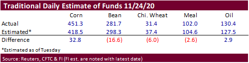
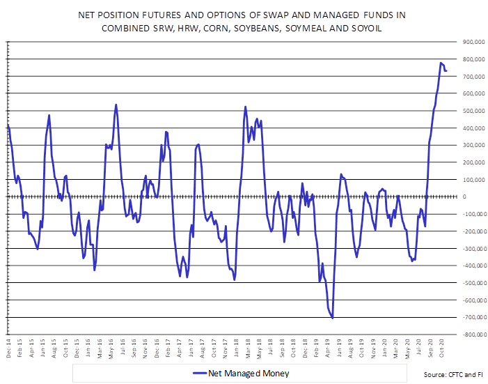
The
traditional fund position in corn was 451,339 contracts, about 46,800 short of its record. Soybeans came in at 281,730, just shy of its record of 282,075 contracts.


SUPPLEMENTAL
Non-Comm Indexes Comm
Net Chg Net Chg Net Chg
Corn
309,842 23,777 388,133 8,446 -676,301 -36,875
Soybeans
176,957 -3,174 193,960 -3,505 -373,705 7,564
Soyoil
80,729 3,121 130,595 1,546 -230,469 -3,077
CBOT
wheat -6,954 7,886 139,354 324 -116,597 -5,607
KCBT
wheat 23,843 556 71,697 2,649 -96,567 -4,295
=================================================================================
FUTURES
+ OPTS Managed Swaps Producer
Net Chg Net Chg Net Chg
Corn
287,599 8,711 239,306 18,254 -647,010 -43,240
Soybeans
203,810 -4,964 122,838 -3,417 -376,384 7,646
Soymeal
71,135 -7,351 72,002 -2,208 -194,261 11,455
Soyoil
105,341 1,563 92,047 -3,080 -240,514 1,908
CBOT
wheat 15,299 884 87,216 -4,169 -102,785 -2,029
KCBT
wheat 48,421 455 43,317 2,027 -92,347 -4,196
MGEX
wheat 5,854 -207 2,122 -671 -14,426 -407
———- ———- ———- ———- ———- ———-
Total
wheat 69,574 1,132 132,655 -2,813 -209,558 -6,632
Live
cattle 40,023 2,090 68,360 -141 -116,387 -974
Feeder
cattle -697 115 7,078 85 -2,929 -360
Lean
hogs 36,433 723 48,073 -560 -85,679 386
Corn.
-
CBOT
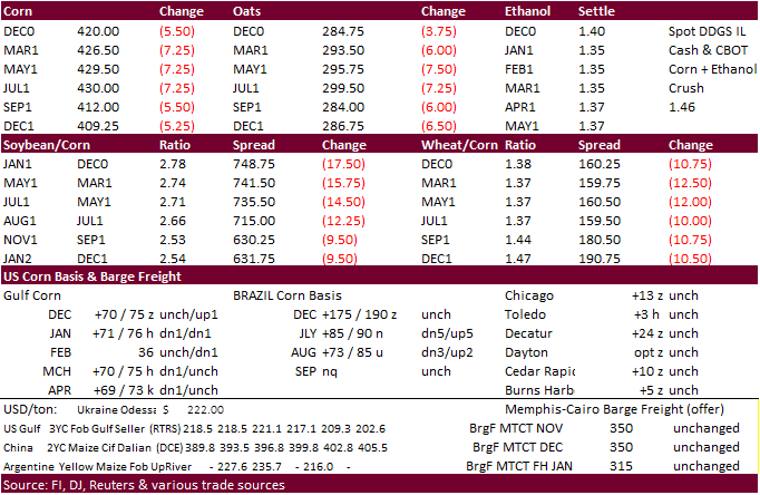
corn traded lower after South America saw rain over the weekend. Note the front month contracts hitting contract highs overnight. March corn dropped 8.0 cents to $4.26. Strong support for March corn is seen at $4.21, lower end of a 4-month trend channel.
(modified close below)
-
Funds
sold an estimated net 28,000 corn contracts. -
China
approved sorghum imports from Mexico, starting today. Mexico produced 4.3 million tons of sorghum in 2019-20. China imported a combined 4 million tons so far this year.
-
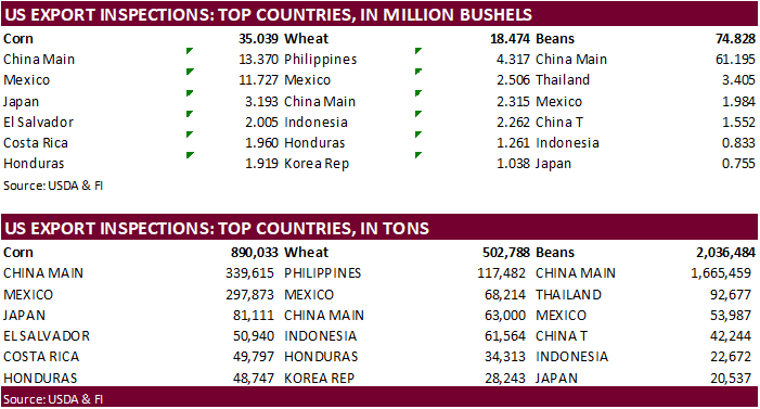
USDA
US corn export inspections as of November 26, 2020 were 890,033 tons, within a range of trade expectations, above 832,882 tons previous week and compares to 439,633 tons year ago. Major countries included Mexico for 294,535 tons, China Main for 200,860 tons,
and Colombia for 140,216 tons. -
USDA
announced a combined 344,00 tons of corn sold to unknown. -
The
USD revered course by afternoon trading to trade about 9 points higher and WTI crude was $0.16 lower, at the time this was written.
-
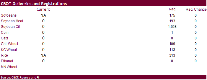
December
FND deliveries were zero across the board. The cost of carry does not support deliveries. For many of the agriculture commodities.
-
South
Korea reported an outbreak of H5N8 bird flu on a duck farm in the southwestern part of the country. -
By
today, the US biofuel trade should have seen a final decision by the EPA for 2021 mandates, but we have yet to see a proposed draft for the matter. The Renewable Fuels Association in a letter asked the Trump Administration’s EPA to stand aside and wait for
the new administration to handle regulations. -
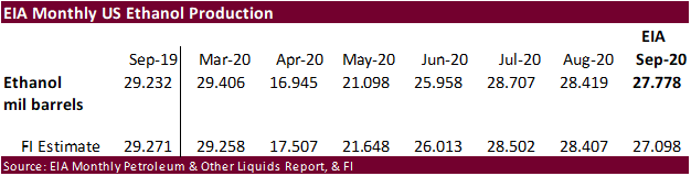
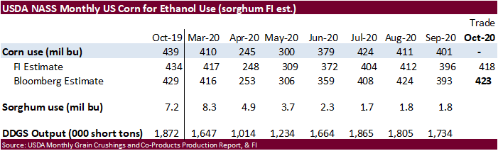
September
ethanol production totaled 27.778 million barrels, below 28.419 million for the month of August and compares to 29.232 million in September 2019. We are using 5.100 billion bushels for corn for ethanol use, 50 million above USDA.
Corn
Export Developments
- USDA
announced private exporters sold:
–Export
sales of 140,000 metric tons of corn for delivery to unknown destinations during the 2020/2021 marketing year
–Export
sales of 204,000 metric tons of corn received in the reporting period for delivery to unknown destinations during the 2020/2021 marketing year
Updated
11/30/20
March
corn is seen
trading in a $4.15 and $4.40 range.