PDF Attached
USDA
released its annual baseline S&D’s
-
USDA
FORECASTS 2021/22 U.S. CORN PLANTINGS AT 90.0 MILLION ACRES, CROP AT 14.890 BILLION BUSHELS -
USDA
FORECASTS 2021/22 U.S. SOYBEAN PLANTINGS AT 89.0 MILLION ACRES, CROP AT 4.465 BILLION BUSHELS -
USDA
FORECASTS 2021/22 U.S. ALL-WHEAT PLANTINGS AT 46.0 MILLION ACRES, CROP AT 1.890 BILLION BUSHELS -
USDA
PROJECTS 2021/22 U.S. CORN ENDING STOCKS AT 2.257 BILLION BUSHELS, SOY ENDING STOCKS AT 255 MILLION BU, WHEAT ENDING STOCKS AT 830 MILLION BU

Weather
and Crop Progress
MOST
IMPORTANT WEATHER IN THE WORLD
- Argentina
and Brazil received insignificant precipitation during the Friday through Sunday period and temperatures were warm enough to accelerate drying across both countries - Topsoil
moisture was already exhausted in Argentina Friday outside of Buenos Aires and immediate bordering areas.
- Topsoil
moisture in Brazil was already short to very short from western Rio Grande do Sul and Paraguay to western Sao Paulo, southwestern Minas Gerais and parts of southeastern Goias Friday with short topsoil moisture in Mato Grosso do Sul - Limited
rain and warm weather during the weekend has further depleted soil moisture and raised stress for recently emerged crops in all of the above areas - Soil
conditions are rated favorably in Bahia, northern and eastern Minas Gerais, Espirito Santo, Rio de Janeiro and eastern Mato Grosso, but timely rain must continue
- The
next ten days of rain will be of critical importance for grain, oilseeds, cotton, rice, sugarcane, citrus and coffee - Confidence
is high that all of these areas will get rain sufficient to maintain crop development except in far southern Brazil and eastern Argentina - Rain
did develop in Paraguay and a few immediate neighboring areas of Brazil Sunday and overnight along with a few random showers of limited significance in Argentina - South
America rainfall over the next ten days will be most significant from Mato Grosso, Bolivia, Paraguay and northern Argentina to Minas Gerais, Espirito Santo, Rio de Janeiro, Sao Paulo and Parana, Santa Catarina and northern Rio Grande do Sul - All
crops in these areas will receive enough rain for at least temporary improvement in topsoil moisture; however, some of the precipitation will be erratic and light leaving pockets of drier soil and leaving some concern in the long term outlook
- Northeastern
Brazil will be driest over the next ten days; including Bahia, Piaui and Tocantins in Brazil and from western and southern Rio Grande do Sul, Brazil into much of eastern Argentina - Net
drying is expected in these areas resulting in some crop stress - Temperatures
will be seasonable in the next two weeks - South
Africa’s topsoil moisture Friday was rated mostly favorable, but dryness was present in the far east and from the heart of Free State into southern Northern Cape and western parts of Eastern Cape - Recent
rain has improved crop and field conditions, but more is needed and more is coming - South
Africa will experience frequent rain in the central and east over the next ten days bolstering topsoil moisture and improving spring and summer crop planting and establishment conditions - Winter
wheat, barley and canola harvest progress may have been briefly slowed during the weekend due to showers in the west, but this week will be drier protecting grain quality and promoting fieldwork - Russia’s
Southern Region, Ukraine and Kazakhstan will receive minimal precipitation over the coming week - Soil
temperatures are still supportive of some crop development, but cooling is bringing down soil temperatures and crop dormancy is not far away - Recent
precipitation has improved topsoil moisture just enough to improve some crop establishment, but most wheat, barley, rye and rapeseed will be vulnerable to winterkill this year if temperatures drop to critical levels without sufficient snow on the ground
- There
is no threat of such conditions in the next couple of weeks, but time has mostly run out for better crop establishment prior to dormancy - Australia
weekend precipitation was infrequent and light allowing fieldwork to advance favorably - The
only exception was in central Queensland where locally strong thunderstorms produced 0.80 to 2.20 inches of rain benefiting a few summer grain, cotton and oilseed areas - Winter
grain and oilseed maturation and harvesting advanced well in the south - Soil
moisture was good for spring and summer crop planting in New South Wales, but there is still need for significant rain in Queensland - Weather
over the next ten days will be dry biased supporting winter crop maturation and harvest progress and summer grain and cotton planting - Rain
is needed in Queensland and parts of New South Wales and this need will increase for summer crops over the next ten days - China
weather during the weekend was mostly dry and temperatures were mild to warm - Soil
conditions have been drying out recently in the North China Plain and Yellow River Basin which is not unusual for this time of year, but winter crops would benefit from some rain - Dry
weather in much of eastern China recently has been great for winter crop planting and summer crop harvesting - Little
rain is expected over the next week - Rain
is expected to increase in parts of east-central China, the Yellow River Basin and North China Plain Nov. 16-20 - The
moisture boost should prove to be very well timed and beneficial to winter crop establishment - India
rain during the weekend was limited to the far south which is not unusual for this time of year. - The
moisture was good for winter crop planting and development, but a little disruptive to summer crop maturation and harvesting - Similar
conditions were expected for the next ten days - Harvesting
and planting should advance well around the showers - Europe
weekend weather was limited to southwestern France, Spain and Portugal and sufficient amounts resulted to support improved topsoil conditions - Soil
moisture Friday was rated mostly favorably for winter crops, but some dryness continues in pockets across the Mediterranean region - Soil
temperatures remain warm enough for additional winter crop development except from northeastern Romania into western Ukraine, Belarus and Baltic States where crops are becoming semi-dormant - Europe’s
weather over the next ten days will be limited on precipitation allowing late season farming activity to advance swiftly - Winter
crops will become a little better established as temperatures remain warmer than usual - North
Africa received a few erratic showers during the weekend, but the region still needs a general soaking in the next few weeks to bolster soil moisture for autumn planting of wheat and barley - Not
much rain is expected for a while - U.S.
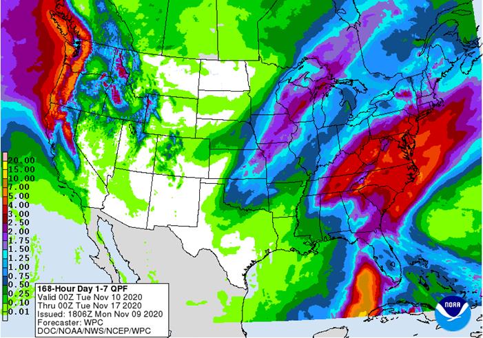
weather during the weekend was dry east of the Rocky Mountains except in central Montana and in a parts of the northern Plains and upper Midwest where rain and snow evolved along
- Moisture
totals in central Montana ranged up to 0.86 inch through dawn today - Doppler
Radar suggested some locations in central Montana had received 0.50 to 1.50 inches through Sunday afternoon
- snowfall
ranged from 9 to 14 inches with local totals to 19 inches om interior northeastern and north-central Montana 1 to 3 and local totals to 8 inches in southern and interior southeastern parts of the state - Rain
and a some snow developed Sunday night and early today in Minnesota and the eastern Dakotas with moisture totals to 0.77 inch - Rain
also fell in the Pacific Northwest during the weekend with up to 0.77 inch in the Columbia River Basin with 1.34 inches of rain in northern Nevada - Weekend
temperatures were quite warm to hot for this time of year in the central and southern Plains with highs in the 70s and some 80s Fahrenheit - Windy
conditions also occurred in the central and southern Plains and western Corn Belt - Windy
conditions also occurred in the northern Plains during the weekend with speeds in 30 to 50 mph and some greater gusts - Montana’s
blizzard that occurred during the weekend extended into the central Canada Prairies and it will end today
- Moisture
totals in Canada reached 2.75 inches in southwestern Saskatchewan and 1.89 inches at Kindersley, SK (located in west-central parts of the province)
- Moisture
totals in Alberta ranged from 0.05 to 0.80 inch while Saskatchewan reported 0.25 to 0.80 inch outside of the areas noted above - Manitoba
precipitation was minimal with a trace to 0.15 inch - Travel
delays and livestock stress will continue today, although the worst weather is over - Rain
with some snow and sleet will occur in the western U.S. Corn Belt early this week before shifting to the Great Lakes region during mid-week - Moisture
totals will vary from 0.30 to 1.25 inches with local totals approaching 2.00 inches
- Southeastern
U.S. weather will be marred by periods of rain from Tuesday night through Friday with Virginia and the Carolinas wettest - Rain
totals of 1.00 to 4.00 inches and locally more will result - Very
little precipitation will occur in the Great Plains from the Dakotas through eastern Colorado and western Kansas to western Texas - These
areas will not be totally dry, but the light precipitation expected will be brief having little impact on winter crop conditions or establishment - These
areas will continue drier biased through Nov. 20 and perhaps into the week of Nov. 22 - Waves
of precipitation are expected in the Pacific Northwest and Great Basin during the next ten days with some rain in central and northern California as well
- The
moisture will be welcome and should improve soil moisture for better winter crop establishment - Mountain
snowpack should increase for better runoff in the spring - West
Texas precipitation will be quite limited through the next ten days especially in the high Plains region - Some
rain is expected in the Rolling Plains Thursday into Friday - U.S.
Delta weather will continue dry biased through the next ten days favoring fieldwork of all kinds - There
is some potential for precipitation in the north, but central and southern areas will be dry biased - U.S.
Corn and Soybean areas of the Midwest will experience alternating periods of rain and sunshine over the next couple of weeks which may slow some forms of fieldwork and a little drier weather might be welcome - However,
most of the rain will be great enough to seriously impact fieldwork for an extended period of time - Southeast
Canada’s grain and oilseed areas will experience a little precipitation Tuesday and during the coming weekend with good drying conditions most other days - The
environment will be good for harvesting - Tropical
Storm Eta may become a hurricane tonight and Monday - The
storm moved across central Cuba early Sunday with rain and wind from the storm impacting sugarcane and citrus areas - Damage
to citrus, sugarcane and unharvested rice may have occurred - Flooding
resulted - The
storm center at 0700 EST today was located 55 miles west northwest of Dry Tortugas, Florida or 80 miles west northwest of Key West, Florida moving northwesterly at 13 mph and producing maximum sustained wind speeds of 65 mph.
- Waves
of rain impacted Florida, the Bahamas and Cuba during the weekend and early today
- Damage
to Florida citrus and sugarcane is not expected to be significant, but a little citrus fruit droppage is possible in southwestern production areas
- Peak
wind speeds reported in the past two days have varied from 22 to 45 mph - Citrus
in the remainder of Florida’s peninsula will be impacted by occasional rain, but no damaging conditions - Broward
County Florida has received more than 12.00 inches of rain since Friday resulting in some significant flooding - Heavy
rain and flooding also occurred from southern Palm Beach County to Miami County and farther southwest through the Florida Keys where 3.00 to 6.00 inches resulted - Eta
will move westerly this morning and then west southwesterly this afternoon. The storm could move more to the southwest and might end up a short distance north of the western tip of Cuba in a couple of days - The
storm will then turn more to the north northeast during the balance of next week bringing the storm inland over the Cross City area of Florida at the end of this week or during the weekend - Eta
will weaken as it comes northward - Eta
may not be the last tropical cyclone to impact the Atlantic Ocean, Caribbean Sea or Gulf of Mexico - Another
disturbance may form in the southern Caribbean sea late this week and during the weekend - A
subtropical storm may also be forming in the central Atlantic Ocean, but it will move away from North America - Tropical
Storm Etau evolved over the South China Sea Sunday and was located 273 miles southeast of Da Nang, Vietnam at 12.5 north, 110.9 east. Movement was west southwesterly at 9 mph while maximum sustained wind speeds were reaching 46 mph - Etau
will move west southwesterly into southern portions of Central Vietnam tonight and Tuesday - The
storm will come inland as a weakening tropical storm producing heavy rain and moderate wind that might impact personal property, coffee and other crops produced from the coast into the Central Highlands through mid-week this week - Tropical
Depression Vamco east of Philippines will become a tropical storm today and a typhoon prior to hitting the Philippines Wednesday. The storm will move across southern Luzon Island Wednesday before moving farther to the west into central Vietnam during the coming
weekend - Excessive
rainfall may impact both northern parts of the Philippines and central Vietnam
- Damage
to crops and property is expected in both countries - Multiple
precipitation events impacting Vietnam’s central coast over the next week will result in rain totals of 6.00 to 15.00 inches and local totals in excess of 20.00 inches.
- Flooding
has been and will continue a serious impact along the central Vietnam coast where impressive rain totals in the past 30 days - More
disruption to commerce and shipping will occur because of the additional rain - Southern
Oscillation Index was +2.57 this morning; the index will rise later this week - Mexico
precipitation will be quite limited over the coming week favoring summer crop maturation and harvesting
- Portions
of Central America will remain wetter than usual into mid-month - Rain
will be greatest in Guatemala, El Salvador, Costa Rica, Nicaragua and Panama
- West-central
Africa will experience erratic rain through the next ten days favoring crop areas closest to the coast
- Daily
rainfall is expected to be decreasing as time moves along which is normal for this time of year - East-central
Africa rain will be erratic and light over the coming week in Ethiopia while rain occurs frequently from Uganda and southwestern Kenya into Tanzania
- Ethiopia
will be wetter next week while showers and thunderstorms continue elsewhere - New
Zealand rainfall will be near to above average in North Island while near to below average in South Island - Temperatures
will be near to below average
Source:
World Weather Inc.
Monday,
Nov. 9:
- USDA
weekly corn, soybean, wheat export inspections, 11am - U.S.
winter wheat conditions; harvest for soybeans, corn, cotton, 4pm - Brazil
Unica cane crush, sugar production (tentative) - Ivory
Coast cocoa arrivals - EU
weekly grain, oilseed import and export data - EARNINGS:
BRF SA
Tuesday,
Nov. 10:
- USDA’s
monthly World Agricultural Supply and Demand (WASDE) report, noon - China’s
agriculture ministry (CASDE) releases monthly report on supply, demand - Malaysian
Palm Oil Council webinar on China’s post-pandemic palm oil demand - Malaysian
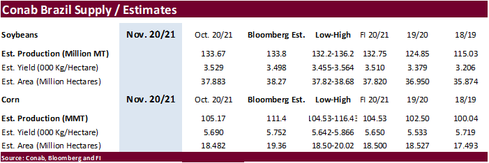
Palm Oil Board releases data on end-October stockpiles, exports, production - Conab’s
data on area, output and yield of soybeans and corn in Brazil - Malaysia
Nov. 1-10 palm oil export data from AmSpec, SGS
Wednesday,
Nov. 11:
- EARNINGS:
JBS, Barry Callebaut - HOLIDAY:
U.S. (Veterans Day, federal govt closed, CME trading unaffected), France, Canada
Thursday,
Nov. 12:
- Port
of Rouen data on French grain exports - Vietnam
customs data on coffee, rice and rubber exports in October - EIA
U.S. weekly ethanol inventories, production - EARNINGS:
BayWa, Marfrig
Friday,
Nov. 13:
- ICE
Futures Europe weekly commitments of traders report, 1:30pm (6:30pm London)
- NOTE:
CFTC Commitments of Traders report, usually released on Fridays, is scheduled for Monday, Nov. 16, due to U.S. federal holiday - USDA
weekly crop net-export sales for corn, soybeans, wheat, cotton, pork, beef, 8:30am - FranceAgriMer
weekly update on crop conditions - New
Zealand Food Prices
Saturday,
Nov. 14:
- China
Animal Agriculture Association summit on hog recovery, ASF vaccine progress
Source:
Bloomberg and FI


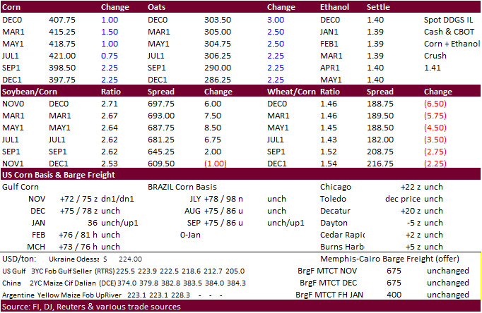
USDA
inspections versus Reuters trade range
Wheat
304,239 versus 250000-500000 range
Corn
690,079 versus 650000-1000000 range
Soybeans
2,496,308 versus 1950000-2250000 range
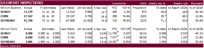
GRAINS
INSPECTED AND/OR WEIGHED FOR EXPORT
REPORTED IN WEEK ENDING NOV 05, 2020
— METRIC TONS —
————————————————————————-
CURRENT PREVIOUS
———–
WEEK ENDING ———- MARKET YEAR MARKET YEAR
GRAIN 11/05/2020 10/29/2020 11/07/2019 TO DATE TO DATE
BARLEY
2,295 0 3,593 12,162 15,401
CORN
690,079 740,612 581,856 7,576,894 4,344,347
FLAXSEED
24 0 0 413 172
MIXED
0 0 0 0 0
OATS
100 0 499 1,096 1,297
RYE
0 0 0 0 0
SORGHUM
72,005 103,320 25,486 717,970 401,016
SOYBEANS
2,496,308 2,389,742 1,348,193 19,457,451 10,904,221
SUNFLOWER
0 0 0 0 0
WHEAT
304,239 313,331 539,920 11,703,183 11,456,105
Total
3,565,050 3,547,005 2,499,547 39,469,169 27,122,559
————————————————————————-
CROP
MARKETING YEARS BEGIN JUNE 1 FOR WHEAT, RYE, OATS, BARLEY AND
FLAXSEED;
SEPTEMBER 1 FOR CORN, SORGHUM, SOYBEANS AND SUNFLOWER SEEDS.
INCLUDES
WATERWAY SHIPMENTS TO CANADA.
Corn.
-
US
CBOT corn futures traded two-sided, ending higher. Easing Covid-19 demand destruction fears and rally in outside markets supported prices. US cash markets were slightly softer. Rain is expected in Brazil during the next ten days, but Argentina’s weather
will continue to see ongoing dry conditions. After election results, there was talk China may try to renegotiate the Phase One US/China trade deal but it will take months for this to become realistic, in our opinion, and by the time it comes up, China will
have committed to most of the 40+ billion of US agriculture commitments. -
US
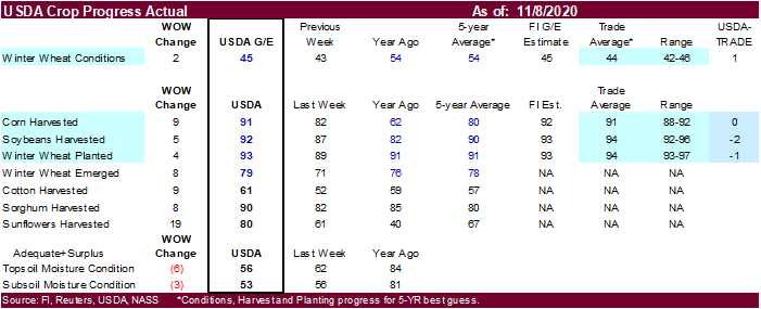
corn harvesting progress was reported at 91 percent, up 9 points from the previous week and compares to 62 percent year ago and 80 percent average. Traders were looking for 91 percent.
-
Today
was day 2 of the GS roll.
·
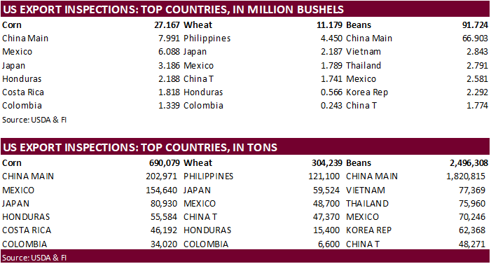
USDA US corn export inspections as of November 05, 2020 were 690,079 tons, within a range of trade expectations, below 740,612 tons previous week and compares to 581,856 tons year ago. Major countries
included China Main for 202,971 tons, Mexico for 154,640 tons, and Japan for 80,930 tons.
·
German confirmed a H5N8 bird flu case in the northern part of the country.
CME
Pork Cut Out futures began trading
Corn
Export Developments
-
Iranian
state-owned animal feed importer SLAL seeks up to 60,000 tons of animal feed corn, 60,000 tons of feed barley and 60,000 tons of soymeal, on Wednesday, Nov. 11, for shipment in December 2020 and in January 2021. -
Both
South Korea’s FLC and MFG bought a combined 268,000 tons of corn last week.
Updated
11/05/20
December
corn is seen in a $3.90-$4.25 range