PDF Attached
- Hurricane
Eta moved into northeastern Nicaragua Tuesday evening producing horrific wind, torrential rain and a very impressive storm surge resulting in considerable property damage and damage to infrastructure - Crop
damage is also anticipated, although not yet confirmed - Wind
speeds were sustained at 140 mph at the time of landfall - At
0700 CDT today the storm was 90 miles west of Puerto Cabezas, Nicaragua at 13.8 north, 85.0 west moving westerly at 8 mph and producing maximum sustained wind speeds of 60 mph.
- Eta
will continue to move across northern Nicaragua and will move through the heart of Honduras while diminishing to a tropical depression over the next couple of days - Remnants
of Hurricane Eta will then return to open water in the northern Caribbean Sea Friday into Saturday and will move across Cuba late this weekend and then to the Florida keys by Monday morning - Flooding
will continue through Friday in Central America and the same is expected over a part of western Cuba and southern Florida late this weekend into early next week - Eta
will not likely reach beyond tropical storm status while impacting Cuba and Florida which will keep damage potentials low - Tropical
Storm Goni will weaken to a depression as it moves into central Vietnam late Thursday and Friday and the system is not expected to produce nearly as much damaging wind and flooding as once feared - Landfall
is expected near Qui Nhon - Goni
was 269 miles east southeast of Da Nang, Vietnam this morning - Rainfall
of 3.00 to more than 9.00 inches will accompany the storm inland over a large part of the middle Vietnam coast
- Tropical
Storm Astani will move through the Bashi Channel Friday, move to a position south of Honk Kong Saturday and then turn to the southeast toward central Vietnam during the latter part of the weekend with landfall early next week - Astani’s
landfall may be south of Da Nang, Vietnam this weekend not far from where Tropical Storm Goni is expected to make landfall - The
storm was 379 miles south of Okinawa, Japan this morning - Rainfall
will be less than 5.00 inches at the time of landfall - Another
tropical weather system will impact Luzon Island and the northern Visayan Islands of the Philippines this weekend and then it will move toward southern Vietnam with some impact there possible late next week - Another
tropical disturbance will impact northern Luzon Island, Philippines late next week with additional heavy rain expected; that could be a larger storm - Unusually
warm to hot air will impact the U.S. Plains and Midwest through the weekend and early next week respectively
- Precipitation
will be kept to a minimum until early next week when a winter storm is possible in the western Corn Belt, northern Plains and upper Midwest - U.S.
Midwest drying through the weekend will be ideal for late summer crop harvesting and winter grain planting and establishment - U.S.
Delta and southeastern states will also experience net drying into early next week with temperatures slowly warming favoring all kinds of fieldwork and supporting winter crop establishment - Bitter
cold air will return to the northwestern U.S. Plains, northern and central Rocky Mountain region and interior parts of the Pacific Northwest next week with cooling likely in the northwest half to two-thirds of the Great Plains, as well - Winter
storms will evolve this weekend and next week in the northwestern U.S. Plains/Canada’s Prairies and in the northern Plains/upper U.S. Midwest respectively
- Very
heavy snow, some rain, thunderstorms, sleet and a little freezing rain will be possible - Snow
accumulations will be greatest from Montana to Manitoba and Saskatchewan from the first storm system this weekend with 8 to 16 inches and possibly as much as 20 inches occurring surrounded by lighter snow - U.S.
hard red winter wheat areas with have opportunity for some precipitation during the late weekend and first half of next week, but the west-central and southwestern Plains will not likely be seriously impacted with precipitation - Nebraska,
northeastern Colorado and eastern Kansas into eastern Oklahoma will likely receive most of the precipitation - Snow
totals will be 1 to 5 inches from northeastern Colorado and northwestern Kansas into central Nebraska - Moisture
totals will vary from 0.05 to 0.20 inch in the northwest, 0.20 to 0.70 inch in the east with a couple of extreme amounts near 1.00 inch on the eastern fringe of crop country - West
Texas precipitation will be minimal through the weekend, but some rain might occur briefly next week
- The
moisture will have a minor impact on the region - U.S.
Delta and southeastern states will be impacted by some rain next week, but it should be brief and light enough to restrict the impact on fieldwork and crop conditions – at least until Tropical Cyclone Eta makes an impact on the region, if it is going to - U.S.
Pacific Northwest will experience a few waves of rain and mountain snow over the next ten days - Blizzard
in eastern and southern Canada’s Prairies this weekend into early next week will slow travel and stress livestock, but the moisture resulting from melting snow should help improve soil moisture for use in the spring - Russia’s
Southern Region and Ukraine’s recent rainfall has ended and the region will not see much precipitation again for a while - The
moisture was good for winter crop establishment, although it is getting very late in the season for good stands especially after many weeks of drought - Eastern
parts of Russia’s Southern Region, the lower Volga River Basin and western Kazakhstan received no appreciable moisture recently and most of these areas will stay dry this week
- Western
Kazakhstan may get a few showers of rain and snow, but resulting moisture will not be significant enough to change unirrigated winter crop conditions - Winter
crops in western Kazakhstan and eastern parts of Russia’s Southern Region are poorly established in unirrigated areas because of drought and no change is expected - Rain
will impact eastern Australia today benefiting spring and summer crops, but keeping winter crops moist and briefly slowing crop maturation and harvest progress - Southeastern
Australia will be dry late this week and into early next week and then may be bothered again by rain during mid-week next week
- The
moisture will raise a little concern about the overall condition of wheat, barley and canola - Another
wave of showers may occur during the weekend - Most
of the winter crops will likely manage the periodic precipitation relatively well, although longer periods of drying will be needed to protect grain and oilseed quality - Queensland,
Australia dryland summer crop areas will get some rain this weekend and it will continue infrequently through the following ten days
- The
moisture will be good for dryland cotton, sorghum and other summer crop planting, emergence and establishment, although greater moisture will be needed in many areas to ensure the best soil moisture - Fieldwork
will be slowed by the precipitation periodically - Unharvested
winter grains could be negatively impacted, but much of the harvest should be complete - Brazil
rainfall Tuesday was confined to the northeast while net drying occurred in most other areas - Brazil
weather through Sunday will not change much with rain continuing in the northeastern one-third of the nation; including areas from northern and eastern Minas Gerais through Tocantins and parts of Goias to Bahia, Espirito Santo and northern Minas Gerais - Sufficient
amounts of rain will fall to maintain wet field conditions in many areas and to bolster soil moisture in other areas - Net
drying is expected elsewhere – not only in Brazil, but in Paraguay and Uruguay as well - Nov.
8-15 weather will continue drier than usual in Uruguay, southern Rio Grande do Sul and a few other random locations in southern Brazil and Paraguay, but most other areas in center west and interior southern Brazil will encounter scattered showers and thunderstorms
that will benefit many areas; Resulting rainfall may be a little light in some areas - Concern
will evolve over soil moisture and long term crop development in portions of far southern Brazil, Paraguay, Uruguay and eastern Argentina through the first half of November and perhaps all month, but some relief from dryness is expected from next week’s showers - Temperatures
will be seasonable with a slight cooler bias this week and with a slight warmer bias next week - Argentina
weather Tuesday was dry and temperatures were mild to warm - Argentina
weather over the coming week will be mostly dry with the few showers that erupt briefly being light and resulting in no serious boost in topsoil moisture - Argentina
rainfall Nov. 8-15 will be a little better with scattered showers and thunderstorms expected in the west and south - The
precipitation will be greatest in the west leaving eastern areas with a drier bias - This
pattern is classic La Nina - Enough
rain may fall in western crop areas to induce some crop improvement especially in Santiago del Estero and northern Cordoba where the driest weather has been prevailing for months - Some
forecast model runs have advertised rain in the east, too, but it if it occurs it is expected to be more sporadic and light - Temperatures
will be seasonable over the next two weeks - The
bottom line remain good for this week because most of the nation has favorable soil moisture for recent past rainfall - Northwestern
areas will be driest - Rain
next week will be very important as more of the nation becomes too dry once again - Some
rain of significance will fall in Georgia and extreme southern parts of Russia’s Southern Region again Friday into the weekend after a few showers occurred earlier this week - China
weather will remain favorably dry over the next ten days favoring winter crop planting and establishment as well as summer crop harvesting - Any
showers that occur will be brief and light causing only a limited amount of disruption to fieldwork - Not
much precipitation fell during the weekend - South
Africa weather Monday was mostly dry and mild to warm. - South
Africa rain will increase today into Thursday - Sufficient
rainfall will fall to bolster soil moisture for better spring and summer crop development - Some
winter crops might benefit from the moisture, but those crops are needing drier weather to promote maturation and harvesting soon - Friday
and Saturday will be dry and then scattered showers and thunderstorms will resume again Sunday through next week providing a very good mix of weather for the nation’s spring and summer crops - India
weather will be favorable for late season crop development and widespread harvesting over the next ten days - Winter
crop planting, emergence and establishment will advance well - Rain
will be confined to the far south and a few areas in the far Eastern States - Waves
of rain will continue to impact parts of Southeast Asia that are not being impacted by tropical cyclones over the next ten days to two weeks; most crop conditions will remain favorable - Brief
periods of precipitation will move across the European continent over the coming week resulting in a favorable mix of moisture and sunshine for winter crops - Fieldwork
will advance around the precipitation - This
weekend and next week should trend drier - Temperatures
will be near to above average - Ontario
and Quebec, Canada will experience limited precipitation over the coming week greatly improving harvest progress in the region after abundant moisture in October - Some
rain will fall briefly during mid-week next week followed by some additional net drying - Southern
Oscillation Index leveled off and began to rise a little during the weekend. The index was +4.66 this morning; the index fell from a peak of +12.58 on October 13 to a low of +3.83 Saturday - The
index will stay in a relatively narrow range for a while - Mexico
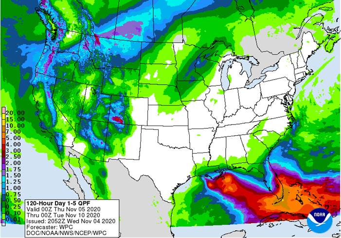
precipitation will be quite limited this week with showers mostly in the far south - Central
America will be wetter than usual this week especially in Nicaragua and Honduras because of Hurricane Eta’s remnants
- Flooding
is likely along with some crop and property damage
·
West-central Africa will experience erratic rain through the next ten days favoring crop areas closest to the coast
- Daily
rainfall is expected to be decreasing as time moves along which is normal for this time of year - Cotton
areas are benefiting from drier weather
·
East-central Africa rain will be erratic and light over the next couple of weeks, but most of Uganda and southwestern Kenya will be impacted while Tanzania and northwestern Ethiopia rainfall is erratic and light
- Some
heavy rain may fall in Uganda early this week
·
New Zealand rainfall will be near to above average in North Island and northern parts of South Island while near to below average in southern South Island
- Temperatures
will be near to below average
Source:
World Weather Inc.
Wednesday,
Nov. 4:
- US
Trade Balance - EIA
U.S. weekly ethanol inventories, production, 10:30am - New
Zealand Commodity Price
Thursday,
Nov. 5:
- USDA
weekly crop net-export sales for corn, soybeans, wheat, cotton, pork, beef, 8:30am - China’s
CNGOIC to publish monthly soybean and corn reports - FAO
World Food Price Index - Guatemala
October coffee exports - Port
of Rouen data on French grain exports - Malaysian
Nov. 1-5 palm oil export data
Friday,
Nov. 6:
- ICE
Futures Europe weekly commitments of traders report, 1:30pm (6:30pm London) - CFTC
commitments of traders weekly report on positions for various U.S. futures and options, 3:30pm - FranceAgriMer
weekly update on crop conditions - HOLIDAY:
Argentina
Saturday,
Nov. 7
- China’s
trade data on soybeans and meat imports
Source:
Bloomberg and FI
US
Trade Balance (Sep): -$63.9Bln(est -$63.9Bln, prevR -$67Bln)
US
ADP Employment Change (Oct): 365K (est 650K, prevR 753k)
Canada
International Merchandise Trade (Sep): -2.35Bln (est -2.35Bln, prev -2.45Bln)
Corn.
-
December
corn futures were higher today on the weaker dollar and decent export demand. Although as of this evening, no official winner in the US Presidential race with Biden leading the electoral count so far.
-
Commodities
in general have been higher earlier this week in part to inflation hedging after polls favored a Biden win.
-
Goldman
Roll starts Friday, the fifth business day of the month. -
Funds
were net buyers of 6,000 net corn futures on the session. -
China
corn futures increased for the first time in three sessions. -
Brazilian
domestic corn prices eased again after appreciating 29 percent during the month of October.
-
Germany
ASF: 114 cases since September 10.
Corn
Export Developments
-
We
heard South Korea’s KFA was in the market for one cargo for April 30 arrival.
Updated 11/02/20
December
corn is seen in a $3.85-$4.10 range
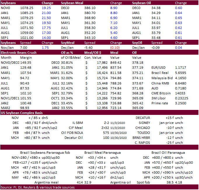
-
CBOT
soybeans are higher on the weaker USD, global demand and inflation hedging. South American weather turning slightly unfavorable with dryness across Argentina and parts of Brazil, and higher outside commodity markets also helped lift the soy complex.
-
China
soybean futures were higher overnight, hitting highest level since July 2008 on concerns over domestic shortages.
-
Funds
were net buyers of 13,000 soybeans, 7,000 soymeal, and 4,000 soybean oil contracts on the session.
-
Soybean
meal rallied $5.10 basis the January. -
Soybean
oil prices earlier this morning were up sharply on higher palm oil futures as traders look for Malaysian palm inventories to sink to a three-year low. China soybean oil and palm oil futures were both up 1.6%.
-
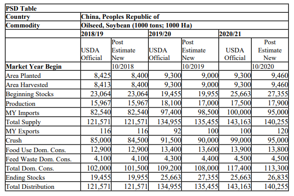
USDA
Attaché estimated China will import only 95 million tons of soybeans during the 2020-21 crop-year after importing a record 98.5 million tons during 2019-20, citing the country already stockpiled soybeans last marketing year and they look for a draw in stocks.
We calculated in early October that China will need to import just over 100 million tons of soybeans to keep up with expanding feed demand.
-
China
crushers were thought to have bought 4-5 Brazilian soybean cargoes for first half 2021 shipment. US interest was quiet. China might be back in the US market for soybeans and feedgrains/DDGS post-election but a delay in election results may push China back
from tendering until next week. -
Malaysian
palm futures were near a 10-month high on ongoing expectations for supplies to tighten in October and La Nina concerns causing flooding. Peak La Nina may start in late November and last through January for Malaysia’s palm oil production areas. Monsoon rains
usually develop around November in Malaysia so with La Nina, wetter than usual season could create local flooding.
USDA
Attaché estimated China will import only 95 million tons of soybeans
during the 2020-21 crop-year after importing a record 98.5 million tons during 2019-20, citing the country already stockpiled soybeans last marketing year. USDA official is at 100 million tons for 2020-21 soybean imports. The Attaché sees a gradual drawdown
in stocks and production up 1 million tons to 18 million tons. The Attaché is also looking for a higher rapeseed production from the previous year (13.5MMT). Note other analysts are higher than the Attaché for soybean and rapeseed production for 2020-21.
US soybean exports to China continue to face an additional 27.5 percent tariff.
https://apps.fas.usda.gov/newgainapi/api/Report/DownloadReportByFileName?fileName=Oilseeds%20and%20Products%20Update_Beijing_China%20-%20Peoples%20Republic%20of_11-01-2020
-
Egypt’s
GASC seeks 3,000 tons of soybean oil and 2,000 tons of sunflower oil from local buyers on November 9 for December 25 to January 15 arrival.
Updated
11/04/20
January
soybeans are seen in a $10.30-$11.00 range
December
soybean meal is seen in a $365-$400 range
December
soybean oil is seen in a 32.50-34.50 range
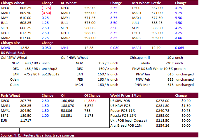
- Wheat
futures closed mixed with SRW lower, and HRW and HRS higher. Helping the higher protein wheat was the talk of China steering away from Australian wheat due to political tensions which puts other global suppliers in play.
- China
is still expected to buy wheat from Australia over the short term despite political tensions. Meanwhile China wheat imports may increase 2.8 million tons this crop year to 7 million tons, according to the CNGOIC.
- Funds
were net sellers of 3,000 contracts on the session. - US
wheat futures Paris (Matif) December wheat was up 1.50 euro at 206.75 euros.
- Much
of Ukraine’s grain crop areas are in good/satisfactory condition, according to APK-Inform. Winter wheat had been planted on 92 percent of the intended area.
-
Egypt’s
GASC seeks wheat on November 5 for LH December – FH January shipment. -
Jordan
passed on 120,000 tons of wheat for March and April 2021 shipment. -
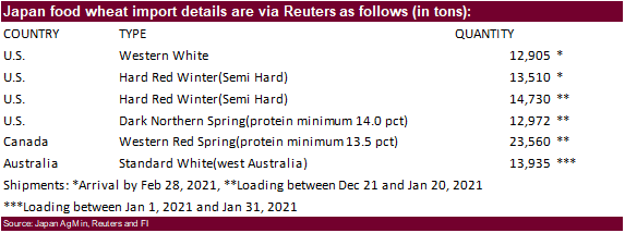
Japan
seeks 91,612 tons of milling wheat this week from the US, Canada and Australia.
-
Syria
seeks 150,000 tons of wheat on November 9. They were in on October 28 for 200,000 tons.
-
Turkey
seeks 550,000 tons of wheat on November 11 for Nov 24 and Dec 18 shipment.
-
Lowest
offer $286.20/ton: Pakistan seeks 320,000 tons of wheat 3 for arrival by November 3 for arrival by the end of January.
·
Syria seeks 37,400 tons of white rice on November 23. White Chinese/Egyptian short grain white rice of third or fourth class was sought. Shipment is sought within three months of order confirmation.
Updated 11/02/20
December Chicago wheat is seen in a $5.85-6.10 range
December KC wheat is seen in a $5.30-$5.65 range
December MN wheat is seen in a $5.25-$5.65 range
Terry Reilly
Senior Commodity Analyst – Grain and Oilseeds
Futures International
One Lincoln Center
18 W 140 Butterfield Rd.
Oakbrook Terrace, Il. 60181
W: 312.604.1366
ICE IM:
treilly1
Skype: fi.treilly

Trading of futures, options, swaps and other derivatives is risky and is not suitable for all persons. All of these investment products are leveraged, and you can lose more than your initial deposit. Each investment product is offered
only to and from jurisdictions where solicitation and sale are lawful, and in accordance with applicable laws and regulations in such jurisdiction. The information provided here should not be relied upon as a substitute for independent research before making
your investment decisions. Futures International, LLC is merely providing this information for your general information and the information does not take into account any particular individual’s investment objectives, financial situation, or needs. All investors
should obtain advice based on their unique situation before making any investment decision. The contents of this communication and any attachments are for informational purposes only and under no circumstances should they be construed as an offer to buy or
sell, or a solicitation to buy or sell any future, option, swap or other derivative. The sources for the information and any opinions in this communication are believed to be reliable, but Futures International, LLC does not warrant or guarantee the accuracy
of such information or opinions. Futures International, LLC and its principals and employees may take positions different from any positions described in this communication. Past results are not necessarily indicative of future results.