PDF Attached includes US S&Ds’
US
election day
2020
USDA Fall Data Users’ Meeting Links
https://www.nass.usda.gov/Education_and_Outreach/Meeting/index.php

KEY
WEATHER ISSUES AROUND THE WORLD
- Vietnam
will experience multiple waves of rain during the next ten days resulting in more excessive rainfall in central parts of the nation after similar conditions have been occurring since October 5 - Some
of today’s computer forecast models have suggested 10.00 to 31.00 inches of rain may accumulate in central Vietnam coastal areas over the next ten days - Da
Nang, International Airport has already recorded more than 67 inches of moisture since October 5
- The
rains have been impacting many areas adversely with the biggest impact on commerce occurring in the port cities of Da Nang and Hue, but other ports and coastal areas have been impacted as well - The
region was mostly dry Monday - Tropical
Storm Goni will weaken to a depression as it moves toward central Vietnam and the system is not expected to produce nearly as much damaging wind and flooding as once feared - Landfall
is now expected late this week near Nha Trang - Goni
was 401 miles east of Da Nang, Vietnam this morning - Tropical
Storm Astani is no longer expected to reach typhoon intensity in the North China sea late this week and it will weaken as it turns southwest toward Vietnam during the latter part of this week and into the weekend - Astani’s
landfall may be near or south of Da Nang, Vietnam this weekend - The
storm was 396 miles south of Okinawa, Japan this morning and will pass through the Bashi Channel (separating Luzon Island, Philippines from Taiwan) Thursday and Friday of this week - Another
tropical weather system will impact Luzon Island, Philippines this weekend and then it will move toward southern Vietnam with some impact there possible late next week - Another
tropical disturbance will impact northern Luzon Island, Philippines late next week with additional heavy rain expected - One
more tropical cyclone is possible east of the Philippines early next week that will move northeast and remain over open water in the western Pacific Ocean during the week next week. - Extremely
dangerous Category Four Hurricane Eta was 30 miles from Puerto Cabezas, Nicaragua at 0700 CDT today moving west southwesterly at 4 mph and producing maximum sustained wind speeds of 145 mph - Eta
will move inland over this morning in northeastern Nicaragua and will bring torrential rain, a huge storm surge and severe flooding to the region along with damaging wind - The
storm will weaken to tropical storm status late today as it moves toward the central Honduras border in northern Nicaragua and to depression status Wednesday
- The
storm will move through interior western and central parts of Honduras Wednesday and Thursday reaching northeastern Guatemala early Friday and then turning to the Belize coast early Saturday morning - Tropical
Depression Eta will then strengthen back to a tropical Storm over the northern Caribbean Sea during the weekend and will pose a threat to Cuba, the Bahamas, southern Florida and the Yucatan Peninsula early next week - Computer
forecast models are beginning to agree the storm may move into the Gulf of Mexico next week and move west northwesterly before curving back toward the southeastern U.S. near mid-month - Unusually
warm to hot air will impact the U.S. Plains and Midwest over the next seven days - Precipitation
will be kept to a minimum until early next week when a winter storm is possible in the western Corn Belt, northern Plains and upper Midwest - U.S.
Midwest drying through the weekend will be ideal for late summer crop harvesting and winter grain planting and establishment - U.S.
Delta and southeastern states will also experience net drying over the coming week with temperatures slowly warming favoring all kinds of fieldwork and supporting winter crop establishment - Bitter
cold air will return to the northwestern U.S. Plains, northern and central Rocky Mountain region and interior parts of the Pacific Northwest next week with cooling likely in the northwest half to two-thirds of the Great Plains, as well - Winter
storms will evolve this weekend and next week in the northwestern U.S. Plains/Canada’s Prairies and in the northern Plains/upper U.S. Midwest respectively
- Very
heavy snow, some rain, thunderstorms, sleet and a little freezing rain will be possible - Snow
accumulations will be greatest from Montana to Manitoba and Saskatchewan from the first storm system this weekend with 6 to 12 inches and possibly more occurring surrounded by lighter snow - U.S.
hard red winter wheat areas with have opportunity for some precipitation during the late weekend and first half of next week, but the west-central and southwestern Plains will not likely be seriously impacted with precipitation - Nebraska,
northeastern Colorado and eastern Kansas into eastern Oklahoma will likely receive most of the precipitation - West
Texas precipitation will be minimal through the weekend, but some rain might occur briefly next week
- The
moisture will have a minor impact on the region - U.S.
Delta and southeastern states will be impacted by some rain next week, but it should be brief and light enough to restrict the impact on fieldwork and crop conditions – at least until Tropical Cyclone Eta makes an impact on the region, if it is going to - U.S.
Pacific Northwest will experience a few waves of rain and mountain snow over the next ten days - Blizzard
in eastern and southern Canada’s Prairies this weekend into early next week will slow travel and stress livestock, but the moisture resulting from melting snow should help improve soil moisture for use in the spring - Russia’s
Southern Region and Ukraine’s recent rainfall has diminished and the region will not see much precipitation again for a while - The
moisture was good for winter crop establishment, although it is getting very late in the season for good stands especially after many weeks of drought - Eastern
parts of Russia’s Southern Region, the lower Volga River Basin and western Kazakhstan received no appreciable moisture recently and most of these areas will stay dry this week
- Western
Kazakhstan may get a few showers of rain and snow, but resulting moisture will not be significant enough to change unirrigated winter crop conditions - Winter
crops in western Kazakhstan and eastern parts of Russia’s Southern Region are poorly established in unirrigated areas because of drought and no change is expected - Western
Australia received widespread “light” rain during the weekend slowing harvest progress in some areas, but possibly benefiting the latest developing winter crops - A
few follow up showers are possible briefly Thursday and again early next week, but the impact will be low - Rain
will develop in southeastern Australia later today and Wednesday benefiting spring and summer crops, but keeping winter crops moist and briefly slowing crop maturation and harvest progress - Southeastern
Australia will be dry late this week and into next Monday and then may be bothered again during mid-week next week
- The
moisture will raise a little concern about the overall condition of wheat, barley and canola - Another
wave of showers may occur during the weekend - Most
of the winter crops will likely manage the periodic precipitation relatively well, although longer periods of drying will be needed to protect grain and oilseed quality - Queensland,
Australia dryland summer crop areas will get some rain this weekend and it will continue periodically through all of next week and into the following weekend - The
moisture will be great for dryland cotton, sorghum and other summer crop planting, emergence and establishment - Fieldwork
will be slowed by the precipitation periodically - Unharvested
winter grains could be negatively impacted, but much of the harvest should be complete - Brazil
rainfall Monday was confined to the northeast while net drying occurred in most other areas
- Brazil
weather through Sunday will not change much with rain continuing in the northeastern one-third of the nation; including areas from northern and eastern Minas Gerais through Tocantins and parts of Goias to Bahia, Espirito Santo and northern Minas Gerais - Sufficient
amounts of rain will fall to maintain wet field conditions in many areas and to bolster soil moisture in other areas - Net
drying is expected elsewhere – not only in Brazil, but in Paraguay and Uruguay as well - Nov.
8-15 weather will continue drier than usual in Uruguay, southern Rio Grande do Sul and a few other random locations in southern Brazil and Paraguay, but most of the region is expected to encounter scattered showers and thunderstorms that will benefit many
areas; Resulting rainfall may be a little light in some areas - Concern
will evolve over soil moisture and long term crop development in portions of southern Brazil, Paraguay, Uruguay and eastern Argentina through the first half of November and perhaps all month, but some relief from dryness is expected from next week’s showers - Temperatures
will be seasonable with a slight cooler bias this week and with a slight warmer bias next week - Argentina
weather during Monday was dry and temperatures were mild - Argentina
weather this week will be mostly dry with the few showers that erupt being very brief and light resulting in not serious boost in topsoil moisture - Argentina
rainfall Nov. 8-15 will be a little better with scattered showers and thunderstorms expected in the west and south - The
precipitation will be greatest in the west leaving eastern areas with a drier bias - This
pattern is classic La Nina - Enough
rain may fall in western crop areas to induce some crop improvement especially in Santiago del Estero and northern Cordoba where the driest weather has been prevailing for months - Some
forecast model runs have advertised rain in the east, too, but it if it occurs it is expected to be more sporadic and light - Temperatures
will be seasonable over the next two weeks - The
bottom line remain good for this week because most of the nation has favorable soil moisture for recent past rainfall - Northwestern
areas will be driest - Rain
next week will be very important as more of the nation becomes too dry once again - Some
rain of significance will fall in Georgia and extreme southern parts of Russia’s Southern Region early this week and again Friday into the weekend - China
weather will remain favorably dry over the next ten days favoring winter crop planting and establishment as well as summer crop harvesting - Any
showers that occur will be brief and light causing only a limited amount of disruption to fieldwork - Not
much precipitation fell during the weekend - South
Africa weather Monday was mostly dry and mild to warm. - South
Africa rain will be erratic today and then a general increase in rain will occur Wednesday into Thursday - Sufficient
rainfall will fall to bolster soil moisture for better spring and summer crop development - Some
winter crops might benefit from the moisture, but those crops are needing drier weather to promote maturation and harvesting soon - Friday
and Saturday will be dry and then scattered showers and thunderstorms will resume again providing a very good mix of weather for the nation’s spring and summer crops - India
weather will be favorable for late season crop development and widespread harvesting over the next ten days - Winter
crop planting, emergence and establishment will advance well - Rain
will be confined to the far south and a few areas in the far Eastern States
- Waves
of rain will continue to impact parts of Southeast Asia that are not being impacted by tropical cyclones over the next ten days to two weeks; most crop conditions will remain favorable - Brief
periods of precipitation will move across the European continent over the coming week resulting in a favorable mix of moisture and sunshine for winter crops - Fieldwork
will advance around the precipitation - This
weekend and next week should trend drier - Temperatures
will be near to above average - Ontario
and Quebec, Canada will experience limited precipitation over the coming week greatly improving harvest progress in the region after abundant moisture in October - Some
rain will fall briefly during mid-week next week followed by some additional net drying - Southern
Oscillation Index leveled off and began to rise a little during the weekend. The index was +4.88 this morning; the index fell from a peak of +12.58 on October 13 to a low of +3.83 Saturday - The
index will rise additionally this week - Mexico
precipitation will be quite limited this week with showers mostly in the far south - Central
America will be wetter than usual this week especially in Nicaragua and Honduras because of Hurricane Eta moving inland and not completely dissipating - Flooding
is likely along with some crop and property damage
- West-central
Africa will experience erratic rain through the next ten days favoring crop areas closest to the coast
- Daily
rainfall is expected to be decreasing as time moves along which is normal for this time of year - Cotton
areas are benefiting from drier weather - East-central
Africa rain will be erratic and light over the next couple of weeks, but most of Uganda and southwestern Kenya will be impacted while Tanzania and northwestern Ethiopia rainfall is erratic and light - Some
heavy rain may fall in Uganda early this week - New
Zealand rainfall will be near to above average in North Island and northern parts of South Island while near to below average in southern South Island - Temperatures
will be near to below average
Tuesday,
Nov. 3:
- U.S.
Purdue Agriculture Sentiment, 9:30am - New
Zealand global dairy trade auction - FT
Global Food Systems conference - EARNINGS:
Andersons, AB Foods - HOLIDAY:
Japan
Wednesday,
Nov. 4:
- US
Trade Balance - EIA
U.S. weekly ethanol inventories, production, 10:30am - New
Zealand Commodity Price
Thursday,
Nov. 5:
- USDA
weekly crop net-export sales for corn, soybeans, wheat, cotton, pork, beef, 8:30am - China’s
CNGOIC to publish monthly soybean and corn reports - FAO
World Food Price Index - Guatemala
October coffee exports - Port
of Rouen data on French grain exports - Malaysian
Nov. 1-5 palm oil export data
Friday,
Nov. 6:
- ICE
Futures Europe weekly commitments of traders report, 1:30pm (6:30pm London) - CFTC
commitments of traders weekly report on positions for various U.S. futures and options, 3:30pm - FranceAgriMer
weekly update on crop conditions - HOLIDAY:
Argentina
Saturday,
Nov. 7
- China’s
trade data on soybeans and meat imports
Source:
Bloomberg and FI
Brazil
selected export data for the month of October
Commodity
October 2020 October 2019
CRUDE
OIL (TNS) 4,743,279 5,266,953
IRON
ORE (TNS) 31,192,800 34,136,907
SOYBEANS
(TNS) 2,492,896 5,076,259
CORN
(TNS) 5,156,818 6,023,744
GREEN
COFFEE(TNS) 225,378 199,473
SUGAR
(TNS) 4,203,124 1,917,690
BEEF
(TNS) 162,684 170,552
POULTRY
(TNS) 296,637 334,626
PULP
(TNS) 1,451,319 1,319,933
Informa
US yield/production estimates
Corn
November 175.7/14.502; October 177.8/14.812
Soybeans
November 50.8/4.183; October 51.9/4.294
StoneX
US yield/production estimates
Corn
November 178.9/14.762; October 179.0/14.942
Soybeans
November 52.1/4.291; October 52.4/4.351
FI
US yield/production estimates (for USDA)
Corn
178.4/14.705
Soybeans
51.8/4.269
US
Factory Orders (M/M) Sep: 1.1% (est 1.0%; prev 0.7%)
–
Factory Orders Ex-Trans (M/M) Sep: 0.5% (est 0.6%; prev 0.7%)
–
Durable Goods Orders (M/M) Sep F: 1.9% (est 1.9%; prev 1.9%)
–
Durables Ex-Transportation (M/M) Sep F: 0.9% (est 0.8%; prev 0.8%)
–
Cap Goods Orders Nondef Ex-Air Sep F: 1.0% (est 1.0%; prev 1.0%)
–
Cap Goods Ship Nondef Ex-Air Sep F: 0.5% (prev 0.3%)
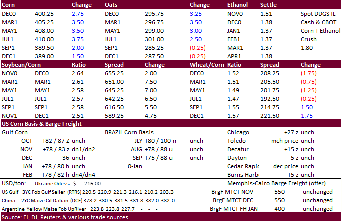
Corn.
-
December
corn futures ended above $4.00/bu, up 3.50 cents. Fund buying during the US election and rally in the outside markets was supportive.
-
Today
was the last day of the Roger Roll and the nearby corn spread was a little soft by early afternoon.
-
WTI
was up $1.12 and USD 57 points lower. -
EU
and other country lockdown concerns could continue to crush commodity prices post US election and weakening economies keep energy prices under pressure.
-
China
corn futures fell on fund selling after prices hit a record late last week.
-
Brazilian
corn prices appreciated 29 percent during the month of October. -
StoneX
sees Brazil’s corn crop at 111.1 million tons. -
Germany
ASF: 114 cases since September 10. -
A
Bloomberg poll looks for weekly US ethanol production to be up 4,000 at 945,000 barrels (925-956 range) from the previous week and stocks up to 156,000 barrels to 19.757 million.
Corn
Export Developments
-
None
reported
Updated
11/02/20
December
corn is seen in a $3.85-$4.10 range