PDF Attached
KEY
WEATHER ISSUES AROUND THE WORLD
- Western
portions of Russia’s Southern Region, Ukraine and Russia’s Central region received precipitation during the weekend with lingering showers early this week - Moisture
totals varying from 0.30 to 1.25 inches occurred in Ukraine while 0.05 to 0.84 inch occurred in western parts of Russia’s Southern Region - The
moisture was welcome and a few areas in southern parts of Russia’s Central Region (immediately north of the central Ukraine border) ranged from 1.00 to 2.00 inches - Most
of the precipitation has come too late in the autumn season to induce good stands in the driest areas, but there will be potential for crop improvement in the spring “if” winterkill is kept to a minimum this winter - Eastern
parts of Russia’s Southern Region, the lower Volga River Basin and western Kazakhstan received no appreciable moisture and most of these areas will stay dry this week
- Western
Kazakhstan may get a little light rain and rain changing to snow briefly Friday into the weekend, but resulting moisture will not be significant enough to change unirrigated winter crop conditions - Winter
crops in western Kazakhstan and eastern parts of Russia’s Southern Region are poorly established in unirrigated areas because of drought - Western
Australia received widespread “light” rain during the weekend slowing harvest progress in some areas, but possibly benefiting the latest developing winter crops - A
few follow up showers are possible briefly Thursday, but the impact will be low - Rain
will develop in southeastern Australia during mid-week this week benefiting spring and summer crops, but keeping winter crops moist and briefly slowing crop maturation and harvest progress - Southeastern
Australia will be dry late this week and into next Monday and then may be bothered again by rain early to mid-week next week
- The
moisture will raise a little more concern about the overall condition of wheat, barley and canola, but drier weather does return late in the week next week and lasts into the following weekend - Most
of the winter crops will likely manage the periodic precipitation relatively well, although longer periods of drying might be welcome - Queensland,
Australia dryland summer crop areas will get some rain late this week through the weekend and into early next week - The
moisture will be great for dryland cotton, sorghum and other summer crop planting, emergence and establishment - Hurricane
Eta will move into northeastern Nicaragua tonight and Tuesday and will impact both Nicaragua and Honduras into Friday - Heavy
rain expected in Honduras, northern Nicaragua and El Salvador - Rainfall
of 5.00 to 15.00 inches and local totals to 25.00 inches will result in notable flooding, landslides and considerable personal property, agriculture and infrastructure damage.
- Rice
and sugarcane will be most vulnerable to damage, but some corn, sorghum, coffee and other crops will also be impacted - At
0700 CDT today was located 140 miles east of Cabo Gracias A Dios, on the Nicaragua/Honduras border, at 14.8 north, 81.1 west moving westerly at 10 mph and maximum sustained wind speeds were reaching 90 mph with tropical storm force wind occurring out 125 miles
from the storm center and hurricane force wind out 25 miles - Worry
over the remnants of Tropical Storm Eta returning to the Caribbean Sea late this week and during the weekend will be rising - Many
computer forecast model runs are advertising such an event with the tropical system returning to the northwestern Caribbean Sea late this week and moving easterly during the weekend - The
storm is advertised to move erratically with Cuba, the Yucatan Peninsula, Florida and the Bahamas all at risk of some influence from the storm through next week - Brazil
rainfall during the weekend was most significant from northern and eastern Mato Grosso through Goias and Tocantins to Bahia, Minas Gerais and Espirito Santo - Moderate
to heavy rain fell in parts of the region especially in Espirito Santo and east-central through northern Minas Gerais where 2.00 to more than 5.00 inches resulted - Net
drying occurred in other Brazil locations especially in the west and south while temperatures were seasonable - Brazil
weather in this coming seven days will not change much with rain continuing in the northeastern one-third of the nation; including areas from northern and eastern Minas Gerais through Tocantins and parts of Goias to Bahia, Espirito Santo and northern Minas
Gerais - Sufficient
amounts of rain will fall to maintain wet field conditions in many areas and to bolster soil moisture in other areas - Net
drying is expected elsewhere – not only in Brazil, but in Paraguay and Uruguay as well - Nov.
8-15 weather will continue drier than usual in Uruguay, southern Rio Grande do Sul and a few other random locations in southern Brazil and Paraguay, but most of the region is expected to encounter scattered showers and thunderstorms that will benefit many
areas, but resulting rainfall may be a little light - Concern
will evolve over soil moisture and long-term crop development in portions of southern Brazil, Paraguay, Uruguay and eastern Argentina through the first half of November and perhaps all month - Temperatures
will be seasonable with a slight cooler bias this week and with a slight warmer bias next week - Argentina
weather during the weekend was dry and temperatures were mild - Argentina
weather this week will be mostly dry with the few showers that erupt being very brief and light resulting in not serious boost in topsoil moisture - Argentina
rainfall Nov. 8-15 will be a little better with scattered showers and thunderstorms expected - The
precipitation will be greatest in the west leaving eastern areas with a drier bias - This
pattern is classic La Nina - Enough
rain may fall in western crop areas to induce some crop improvement especially in Santiago del Estero and northern Cordoba where the driest weather has been prevailing for months - Some
forecast model runs have advertised rain in the east, too, but it if it occurs it is expected to be more sporadic and light - Temperatures
will be seasonable over the next two weeks - The
bottom line remain good for this week because most of the nation has favorable soil moisture for recent past rainfall - Northwestern
areas will be driest - Rain
next week will be very important as more of the nation becomes too dry once again - U.S.
weather trended drier biased during the weekend with some warming followed by a new bout of cooling - The
environment was improving for more aggressive harvesting in the lower Midwest, Delta and southeastern states, although more drying was needed and should evolve this week - Winter
crop planting likely resumed in some areas and should increase as drier weather continues this week.
- Temperatures
are expected to be notably warmer than usual this week, but much colder next week in the Plains and far western states - U.S.
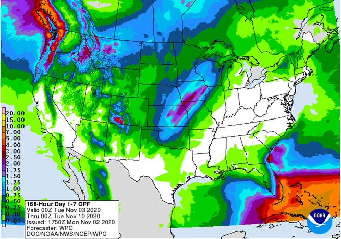
cooling is likely in far western U.S. this weekend and two storm systems will then evolve in the central United States - Storm
number one occurs during the weekend (Nov. 6-8) - Rain
changing to snow and then blizzard conditions may evolve in the northwestern Plains and a part of Canada’s Prairies - Moisture
totals will vary from 0.20 to 0.80 inch with a few amounts to 1.35 inches - Heavy
snow will fall from Montana and western North Dakota to Saskatchewan and a part of Manitoba - Storm
number two evolves in the central Plains Sunday into next Monday and then advances to the upper Midwest during the early part of next week with a trailing cold front bringing some rain to the eastern Midwest next week - Moisture
totals Nov. 8-10 will vary from 0.20 to 0.80 inch with a few amounts of 1.00 to 1.50 inches from eastern portions of the central Plains to the western Great Lakes region and Minnesota - Eastern
Kansas to Minnesota and Wisconsin will be wettest - Heavy
snow will fall from north-central and northeastern Kansas through Iowa to Wisconsin and Minnesota - Remnants
of Hurricane Eta could impact Florida later next week, although confidence is low - U.S.
hard red winter wheat areas will get additional precipitation this weekend into early next week with the southwestern and west-central Plains getting the lightest amount of moisture - West
Texas could receive a few showers late this weekend into early next week, but resulting amounts will be brief enough to limit the impact on cotton and other summer crop harvesting - U.S.
Pacific Northwest will receive some rain and mountain snow late this workweek and again briefly next week - Moisture
totals are not likely to be very great - The
moisture will be welcome, but not enough on its own for a serious improvement in soil moisture, but water supply and mountain snowpack for 2021 may begin to improve - U.S.
Delta and interior southeastern states will be dry for much of the coming week with a brief bout of rain coming with a frontal system during mid-week next week - A
close watch on the remnants of Hurricane Eta will be warranted for possible impact on Florida or perhaps a few areas farther north, but not before the second half of next week - Other
precipitation in western portions of the Commonwealth of Independent states will be light and helpful for maintaining favorable soil moisture for use in the spring. - Some
rain of significance will fall in Georgia and extreme southern parts of Russia’s Southern Region early this week and again Friday into the weekend - China
weather will remain favorably dry over the next ten days favoring winter crop planting and establishment as well as summer crop harvesting - Any
showers that occur will be brief and light causing only a limited amount of disruption to fieldwork - Not
much precipitation fell during the weekend - Typhoon
Goni moved into the central Philippines during the weekend and was downgraded to tropical storm status while moving into the South China Sea Sunday and today - The
storm produced nearly 11.00 inches of rain in southeastern Luzon Island and nearly 7.00 inches in Samar with lighter rain to the west - Tropical
Storm Goni is not expected to regain typhoon intensity as it races to central Vietnam early this week - Landfall
in central Vietnam is expected late Wednesday or Thursday as a tropical storm and will bring very heavy rain and windy conditions to Vietnam’s Central Highlands - Some
negative impact is possible on coffee and other crop production areas in the Central Highlands, but damage should be low - Landfall
should be between Qui Nhon and Quang Ngai around 1200 GMT Thursday - Heavy
rain from the storm will push across Vietnam’s Central Highlands and then into Cambodia where flooding has already been a problem at times in the past 30 days - Tropical
Depression Astani will remain northeast of the northern Philippines for a while this week, but the storm will likely pass to the north of Luzon Island Thursday and Friday and then move toward southern China with landfall in Guangdong or Guangxi late this week - Astani
will become a tropical storm and possibly a typhoon for a little while before it comes close to any landmass
- Weakening
is expected prior to landfall in China - Another
tropical cyclone may form east of the Philippines late this week and move toward Luzon Island with landfall possible during the weekend
- South
Africa weekend rain was greatest from western and central North West through central and eastern Free State to western and southern Natal and eastern parts of Eastern Cape - Moisture
totals varied from 0.60 to 3.25 inches with amounts of 2.00 to 3.25 inches common in eastern Free State and Natal
- Additional
rain is needed nationwide to support summer crop planting - South
Africa rain will be erratic until Wednesday when a general increase in rain occurs across the nation through Thursday - Sufficient
rainfall will occur to bolster soil moisture for better spring and summer crop development - Some
winter crops might benefit from the moisture, but those crops are needing drier weather to promote maturation and harvesting soon - Friday
and Saturday will be dry and then scattered showers and thunderstorms will resume again providing a very good mix of weather for the nation’s spring and summer crops - India
weather will be favorable for late season crop development and widespread harvesting over the next ten days - Winter
crop planting, emergence and establishment will advance well - Rain
will be confined to the far south and a few areas in the far Eastern States - Waves
of rain will continue to impact parts of Southeast Asia that are not being impacted by tropical cyclones over the next ten days to two weeks; most crop conditions will remain favorable - Central
Vietnam will likely be impacted by Tropical Storm Goni during mid- to late week this week with additional heavy rain and strong wind speeds possible near Da Nang, Hue and Qui Nhon - Southern
China may be impacted by Tropical Storm Astani during mid-week before moving toward northern Vietnam later in the week - Central
Vietnam is advertised to be hit by 5 tropical weather systems over the next two weeks perpetuating its excessive moisture and flood problems - The
nation has already been impacted adversely by frequent tropical weather systems since October 5 - Brief
periods of precipitation will move across the European continent over the coming week resulting in a favorable mix of moisture and sunshine for winter crops - Fieldwork
will advance around the precipitation - This
weekend and next week should trend drier - Temperatures
will be near to above average - Ontario
and Quebec, Canada will experience limited precipitation over the coming week to ten days greatly improving harvest progress in the region after abundant moisture in October - Southern
Oscillation Index leveled off and began to rise a little during the weekend. The index was +4.62 this morning; the index fell from a peak of +12.58 on October 13 to a low of +3.83 Saturday - The
index will rise this week - Mexico
precipitation will be quite limited this week - Central
America will be wetter than usual this week especially in Nicaragua and Honduras because of Hurricane Eta moving inland and not completely dissipating - Flooding
is likely along with some crop and property damage
·
West-central Africa will experience erratic rain through the next ten days favoring crop areas closest to the coast
- Daily
rainfall is expected to be decreasing as time moves along which is normal for this time of year - Cotton
areas are benefiting from drier weather
·
East-central Africa rain will be erratic and light over the next couple of weeks, but most of Uganda and southwestern Kenya will be impacted while Tanzania and northwestern Ethiopia rainfall is erratic and light
- Some
heavy rain may fall in Uganda early this week
·
New Zealand rainfall will be near to above average in North Island and northern parts of South Island while below average in southern South Island
Temperatures
will be near to below average
Source:
World Weather Inc.
Monday,
Nov. 2:
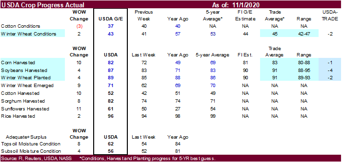
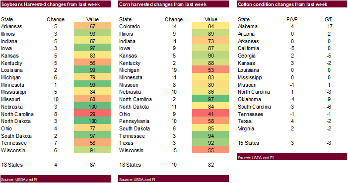
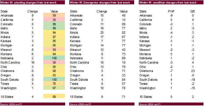
- USDA
weekly corn, soybean, wheat export inspections, 11am - USDA
soybean crush, corn for ethanol, DDGS output, 3pm - U.S.
crop conditions, harvest for soybeans, corn, cotton, 4pm - Costa
Rica, Honduras October coffee exports - Cotton
supply/demand outlook from International Cotton Advisory Committee - Australia
Commodity Index - Ivory
Coast cocoa arrivals - HOLIDAY:
Brazil
Tuesday,
Nov. 3:
- U.S.
Purdue Agriculture Sentiment, 9:30am - New
Zealand global dairy trade auction - FT
Global Food Systems conference - EARNINGS:
Andersons, AB Foods - HOLIDAY:
Japan
Wednesday,
Nov. 4:
- EIA
U.S. weekly ethanol inventories, production, 10:30am - New
Zealand Commodity Price
Thursday,
Nov. 5:
- USDA
weekly crop net-export sales for corn, soybeans, wheat, cotton, pork, beef, 8:30am - China’s
CNGOIC to publish monthly soybean and corn reports - FAO
World Food Price Index - Guatemala
October coffee exports - Port
of Rouen data on French grain exports - Malaysian
Nov. 1-5 palm oil export data
Friday,
Nov. 6:
- ICE
Futures Europe weekly commitments of traders report, 1:30pm (6:30pm London) - CFTC
commitments of traders weekly report on positions for various U.S. futures and options, 3:30pm - FranceAgriMer
weekly update on crop conditions - HOLIDAY:
Argentina
Saturday,
Nov. 7
- China’s
trade data on soybeans and meat imports
Source:
Bloomberg and FI
USDA
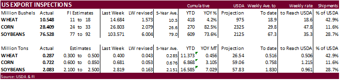
inspections versus Reuters trade range
Wheat
287,059 versus 300000-500000 range
Corn
721,623 versus 600000-1100000 range
Soybeans
2,082,741 versus 1500000-2500000 range
GRAINS
INSPECTED AND/OR WEIGHED FOR EXPORT
REPORTED IN WEEK ENDING OCT 29, 2020
— METRIC TONS —
————————————————————————-
CURRENT PREVIOUS
———–
WEEK ENDING ———- MARKET YEAR MARKET YEAR
GRAIN
10/29/2020 10/22/2020 10/31/2019 TO DATE TO DATE
BARLEY
0 798 3,134 9,867 11,808
CORN
721,623 680,823 283,704 6,867,630 3,762,491
FLAXSEED
0 0 0 389 172
MIXED
0 0 0 0 0
OATS
0 0 0 996 798
RYE
0 0 0 0 0
SORGHUM
94,454 73,531 67,048 637,099 375,530
SOYBEANS
2,082,741 2,818,734 1,483,653 16,584,920 9,556,028
SUNFLOWER
0 0 0 0 0
WHEAT
287,059 399,645 293,971 11,372,672 10,916,185
Total
3,185,877 3,973,531 2,131,510 35,473,573 24,623,012
————————————————————————
CROP
MARKETING YEARS BEGIN JUNE 1 FOR WHEAT, RYE, OATS, BARLEY AND
FLAXSEED;
SEPTEMBER 1 FOR CORN, SORGHUM, SOYBEANS AND SUNFLOWER SEEDS.
INCLUDES
WATERWAY SHIPMENTS TO CANADA.
CME
will revise their futures price limits effective February 2.
StoneX
US yield/production estimates
Corn
November 178.9/14.762; October 179.0/14.942
Soybeans
November 52.1/4.291; October 52.4/4.351
Canadian
Markit Manufacturing PMI Oct: 55.5 (prev 56.0)
US
Markit Manufacturing PMI Oct F: 53.4 (est 53.3; prev 53.3)
US
ISM Manufacturing Oct: 59.3 (est 55.8; prev 55.4)
–
ISM New Orders Oct: 67.9 (est 62.0; prev 60.2)
–
ISM Prices Paid Oct: 65.5 (est 60.5; prev 62.8)
–
ISM Employment Oct: 53.2 (prev 49.6)
Corn.
-
December
corn futures traded lower on long liquidation and Covid-19 fears that could again impact global ethanol demand. Traders were busy shoring up positions ahead of the US election set for Tuesday. Funds as of last Tuesday were 54,100 contracts more long than
expected for the traditional funds. December corn failed to test its psychological $4.00 level, a bearish indication.
-
Some
believe US ethanol demand will slow as more and more states go back on partial lockdown. Parts of Europe are headed back to lockdown, which is viewed bearish for Brent Crude oil, but that product traded higher on Monday.
WTI
crude oil fell to a 5-month low earlier but rebounded by early afternoon.
-
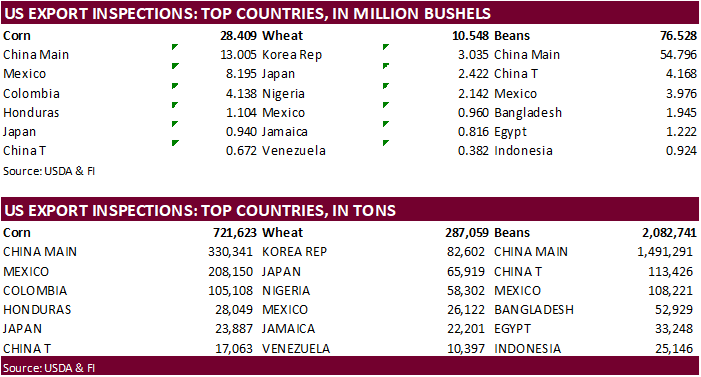
USDA
US corn export inspections as of October 29, 2020 were 721,623 tons, within a range of trade expectations, above 680,823 tons previous week and compares to 283,704 tons year ago. Major countries included China Main for 330,341 tons, Mexico for 208,150 tons,
and Colombia for 105,108 tons. -
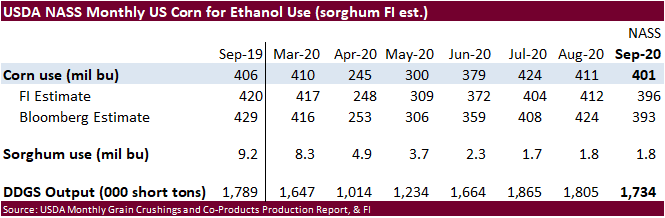
The
US corn for ethanol use during the month of September came in slightly above trade expectations.
-
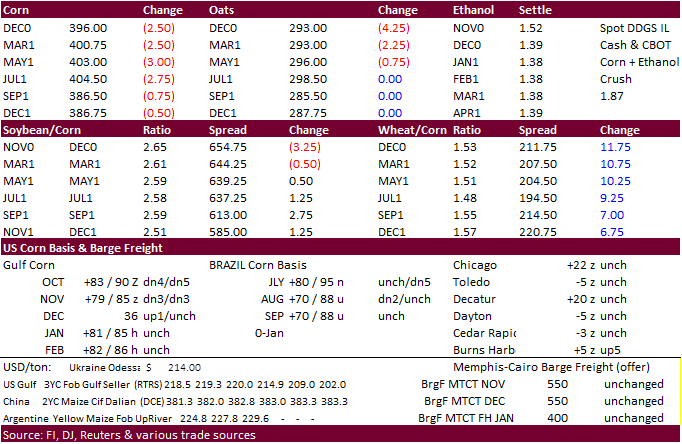
Decatur
corn basis fell 5 cents to 15 over the Dec. -
Brazil
domestic corn prices were a little weaker as 54% of the first corn crop is planted (AgRural). We are picking up that South Korea was in the market for a corn cargo for LH April arrival, and it could originate from the US (not South Africa as earlier reported).
- Germany
ASF: 114 cases since September 10. - South
Korea banned poultry imports from the Netherlands on bird flu concerns. -
Ukraine
grain exports fell 15.8 percent so far in 2020-21 to 16.5 million tons, including 2.5 million tons of corn (4.4MMT year earlier).
Corn
Export Developments
-
Under
the 24-hour announcement system, private exporters sold 204,000 tons of corn to unknown.
Updated
11/02/20
December
corn is seen in a $3.85-$4.10 range