PDF Attached
Reuters
showed funds sold 35k corn, 17k beans and 20k wheat. Sharply
lower trade in US equities and WTI and higher trade in the USD created a risk off session in commodities.
Weather
and Crop Progress
MOST
NOTABLE ISSUES SINCE FRIDAY
- Argentina
will receive rain Thursday into Saturday easing dryness in some western and southern areas and maintaining good soil moisture in eastern crop areas - Rainfall
of 0.30 to 1.00 inch will occur in 70% of the nation with 1.00 to 2.00 inches and locally more from northern La Pampa and northern Buenos Aires to northern Santa Fe and southern Corrientes - Follow
up showers are expected for a little while next week, but much of the rain will not be great enough to change soil moisture - The
12z GFS model run is too wet today for next week - Freezing
temperatures in Argentina during the weekend had no permanent damage on winter wheat, barley or any early season spring crop - The
cold was not unusual for this time of year - Central
and Western Europe is still expected to trend wetter later this week through the weekend with moist areas west of Ukraine, Belarus, central Romania and Bulgaria getting rain - Southern
Spain and Southern Portugal will be drier biased - Additional
rain will fall in far northwestern Europe during the first half of next week while drier weather occurs farther to the east - No
rain is expected from Ukraine, Most of Belarus and Eastern Romania to western Kazakhstan this workweek, but some rain will fall in western Ukraine, Romania, Bulgaria, Moldova and Belarus this weekend
- Moisture
totals in these areas will vary from 0.20 to 0.80 inch with a few 1.00 to 2.00-inch amounts - Eastern
Ukraine will be driest - No
rain is likely for the next ten days in Eastern Ukraine, the middle and lower Volga River Basin and much of Kazakhstan - Russia’s
Northeastern New Lands will not be impacted by significant precipitation over the next ten days
·
The environment will be very good for spring and summer crop maturation and harvest progress
·
Showers will occur in the central New Lands and in a few of the Ural Mountains region where rainfall over by September 30 will vary from 0.30 to 1.00 inch and locally more
- Rain
developed throughout Spain, Portugal and central through southwestern France during the weekend because of Subtropical Storm Alpha that moved across northwestern parts of the Iberian Peninsula.
- Rainfall
varied from 0.25 to 1.10 inches with a few local totals to 2.00 inches - Rest
of Europe was left dry with temperatures well above average in France for a brief period ahead of the weekend rain - East-central
China was left dry during the weekend - The
dry weather was ideal for summer crop maturation and early autumn planting in the Yellow River Basin and North China Plain - Rain
continued to fall periodically in Heilongjiang and Jilin where summer crop maturation and harvest progress has not advanced well yet this year because of too much rain - Additional
moisture totals varied from 0.15 to 0.72 inch with local totals of 1.00 to 3.39 inches in south-central Heilongjiang
- Heavy
rain fell during the weekend from Guangdong to Jiangxi to Fujian where amounts many areas reported 4.60 to 12.79 inches - Some
flooding occurred in the region possibly threatening a little rice and some groundnuts as well as other crops - China
will experience alternating periods of rain and sunshine over the next two weeks - The
best mix of weather will be in the North China Plain and Yellow River Basin while rain continues to fall a little too often in the far northeast part of China - Northeastern
China will not be quite as wet as it has been, however - Abundant
to excessive rain will fall in the south from Sichuan and southern Hubei to Fujian, Guangdong, Guangxi and Yunnan - Inner
Mongolia and northern Heilongjiang, China may experience a little frost this weekend with a more significant bout of cold expected next week - First
frost and freezes normally occur in Northeast China during the last days of September and early October making this a seasonable event - Eastern
Australia received some beneficial rain Friday through Sunday with a needed boost in soil moisture resulting in eastern parts of South Australia, central and northwestern New South Wales and western Queensland - Moisture
totals of 0.30 to 1.63 inches occurred from eastern South Australia into central New South Wales and western Queensland - Moisture
totals farther to the east and south were no more than 0.35 inch - Additional
rain is expected periodically over the next two weeks in eastern parts of the nation - Western
Australia will receive no rain of significance for the coming week, although showers will occur near the lower west and southern coast; interior parts of the state will be left dry - “Some”
rain will develop Sunday in Western Australia and it will move to South Australia early next week and then into eastern portions of the nation later next week - All
of the moisture will be extremely important for winter crop development, but much more will be needed especially in the west - Rain
fell in southeastern Alberta and western and central Saskatchewan Saturday into early today and the precipitation will spread into Manitoba today - The
moisture either has or will disrupt crop maturation and harvest progress briefly, but the moisture will be help improve topsoil conditions for use in the spring - Drier
weather will occur the remainder of this week favoring the resumption of aggressive fieldwork - Temperatures
will be warmer than usual most of this week and slightly cooler next week - Frost
and freezes occurred in Ontario and Quebec, Canada as well as the northeastern United States during the weekend - Low
temperatures were in the middle 20s through the lower 30s Fahrenheit ending the growing season for some corn and soybeans - Damage
to crops should not have been significant - Tropical
Storm Beta was located 70 miles southeast of Port O’Connor, Texas moving westerly at 6 mph and producing maximum sustained wind speeds of 50 mph at 0700 CDT. Tropical storm force wind was occurring out 175 miles from the storm center - No
change in intensity is expected prior to landfall - Landfall
is expected north of Port O’Connor, Texas Early Tuesday morning before drifting northeast toward Galveston and Houston, Texas as a weakening storm Tuesday afternoon into Wednesday - Remnants
of the storm will then move through the lower delta Thursday into Friday morning - Rainfall
this week will range from 2.00 to 6.00 inches from the middle and upper Texas coastal region into the lower Delta and areas northeast into Alabama and northern Georgia - Rain
totals of 6.00 to 10.00 inches may impact southeastern Louisiana and immediate neighboring areas - Rainfall
of 1.00 to 2.00 inches will occur in the northern Delta while amounts in southern Georgia, northeastern Florida and the Carolinas will range from 0.50 to 2.00 inches – most of which will occur during the coming weekend - Hurricane
Teddy at 0500 EDT was located 160 miles southeast of Bermuda at 30.5 north, 63.0 west moving north northeasterly at 9 mph and producing maximum sustained wind speeds of 100 mph with tropical storm force wind occurring out 230 miles
- Hurricane
force wind was occurring out 70 miles from the storm center - Teddy
will pass to the east of Bermuda tonight and should have a low impact on the island, although tropical storm force wind and rough seas are expected along with some light rainfall - Teddy
will move farther to the north reaching Nova Scotia, Canada Wednesday as a mid-latitude storm - Teddy
will then turn to the northeast and move across Newfoundland - Torrential
rain and flooding will occur in southeastern Canada with some property damage likely - Damaging
wind will also occur as Teddy impacts Nova Scotia and Newfoundland - Tropical
Depression Wilfred dissipated overnight - Tropical
Storm Dolphin developed during the weekend well south of Japan, but was expected to approach central Honshu coastal areas Thursday
- Some
heavy rain and windy conditions will accompany the storm inland - Rain
developed from northeastern Sao Paulo into southern Minas Gerais and Rio de Janeiro, Brazil coffee areas overnight and the moisture will continue through Tuesday eventually producing enough moisture to support coffee flowering.
OTHER
WORLD WEATHER ISSUES
- South
Africa still needs significant rain for its winter wheat, barley and canola crops, especially those in eastern production areas - Not
much rain is expected over the coming week, although a few sporadic showers are anticipated - No
precipitation fell in South Africa during the weekend - Temperatures
were warm and will continue warmer than usual - Center
West and southern parts of center south Brazil are advertised to receive scattered showers and thunderstorms today into Wednesday Morning with some follow up rain through the weekend in northern parts of Mato Grosso and areas south into southern Brazil - The
precipitation might eventually help lift topsoil moisture for “some” early season soybean planting, but much more rain will be needed - Coffee
and citrus flowering “may” occur in a few areas from Sao Paulo into southern Minas Gerais and Rio de Janeiro while sugarcane and early corn experience a moisture boost to improve crop development - Follow
up rain will be very important to induce the best early season planting conditions for soybeans and to induce better flowering conditions for coffee and citrus - Southern
Brazil rice, corn and wheat areas will get periodic rainfall through the next two weeks - Crop
and field conditions will either improve or continue good through the end of this month - Xinjiang,
China weather will continue favorable for cotton and other crop maturation and early harvest progress - Alternating
periods of warm and cool weather will occur through the next week to 8 or 9 days with restricted rainfall expected - The
environment will support crop maturation, leaf defoliation and early harvesting - High
temperatures Thursday were in the 70s and 80s Fahrenheit and lows today in the upper 40s and 50s - Frost
and freezes may occur late this week and into the weekend in northeastern Xinjiang, but it will be more likely next week - Other
areas are not likely to experience any threat of frost - India
weather will continue wettest in central, southern and far eastern parts of the nation this workweek while net drying occurs in the north - Monsoonal
precipitation will continue without much withdrawal through the workweek, but a more significant withdrawing trend is expected in the last week of September and early October improving crop maturation conditions in central parts of the nation
- Remnants
of Tropical Storm Noul will into India from Southeast Asia this week and will bring some enhanced rainfall to parts of India
- Once
this disturbance dissipates monsoonal rainfall will begin to withdraw once again - Next
week’s weather will trend drier in central parts of the nation - Weather
conditions in most of India are still favorable, but drying will soon be needed in Gujarat as more rain falls this week
- U.S.
weather over the next two weeks - Net
drying is expected over the coming week in most of the Great Plains and across the Midwest - Rain
will fall in the Delta and southeastern states from mid- through late week this week ending during the weekend all of which will come from Tropical Storm Beta - Rainfall
will range from 2.00 to 6.00 inches from southeastern Texas through the lower Delta to Mississippi, Tennessee, northern Georgia and the Carolinas; however, rainfall will be most significant in Louisiana and southern Mississippi where some flooding is expected - A
few areas in southeastern Louisiana will receive 6.00 to 10.00 inches of rain resulting in some flooding
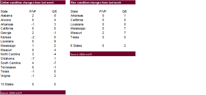
- Cotton,
rice and a few other crops will be negatively impacted by the heavy rain in the lower Delta - Crops
elsewhere are not likely to be significantly impacted by rain from the storm, although wet conditions will induce some harvest delays and could raise the potential for boll rot in the southeastern states - Some
rain will fall in the Pacific Northwest Wednesday through Friday, although mountainous areas will be wettest and the impact on soil moisture in crop areas will not be very great - Most
other areas in the western United States will be dry and warm through October 2
- Rain
will impact the eastern Midwest this weekend and shift to the northeastern and middle Atlantic Coast states early next week - Amounts
in the eastern Midwest will vary from 0.20 to 0.75 inch with a few totals to 1.50 inches - Showers,
drizzle and cool temperatures will occur in the Great Lakes region early next week
- Dry
weather will occur again in the balance of next week in the eastern Midwest, Delta and southeastern states - A
new frontal system will move across the central Plains October 2-4 and into the Midwest Oct 3-6 producing rainfall of 0.20 to 0.80 inch and local amounts of 1.00 to 2.00 inches - Confidence
in this event is low - Summer
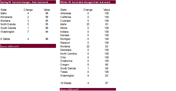
crop maturation and harvest progress will be good in the Great Plains and western Corn Belt this week through the first half of next week - Good
harvest progress is also expected in the eastern Midwest through this workweek and again during next week’s workweek - West
Texas will be dry through much of the next two weeks - Temperatures
will be warmer than usual in the western and central United States while near average in central and southeastern parts of the nation during the week - Cooling
is expected in the eastern one-third of the nation next week - The
bottom line for the U.S. is one of concern for crop conditions in the lower and middle Delta where it will become too wet for a while this week. Concern will also rise over harvest delays in the southeastern states. Most crops will survive the wet bias, but
there will be some concern over cotton fiber quality in both the Delta and parts of the southeastern states. Boll rot potentials will continue to rise in those areas impacted by heavy rain from Tropical Storm Sally once the new moisture from Tropical Storm
Beta arrives later this week. Hard red winter wheat production areas will continue to dry out and significant rain will be needed soon to support planting, emergence and establishment. Otherwise the dry bias in the Plains and Midwest will be good for harvest
progress. - U.S.
weekend weather was generally dry - Some
rain fell in the Northern Rocky Mountain region and in coastal areas of the Pacific Northwest, but few crop areas were impacted - Rain
also fell along the Gulf of Mexico coast and in much of Florida - Rainfall
in Florida varied 1.00 to 4.44 inches in some citrus areas - Temperatures
were seasonable in the east and northwest and warmer than usual in the high Plains region - Southeastern
Canada will experience alternating periods of rain and sunshine will occur through the next two weeks
- The
environment will be good for summer crop maturation and harvesting, although rain will induce some brief delays periodically - West-central
Africa will continue to experience periodic showers and thunderstorms over the next couple of weeks - Rain
Fell during the weekend from Cameroon through Nigeria and Benin to Ivory Coast and Ghana
- Additional
improvement is expected to coffee, cocoa, rice and sugarcane production areas after rain fell significantly during the weekend - Cotton
areas will also continue to receive some rain for a while longer, but need to begin drying out - Most
crops receiving rain will likely benefit from the moisture - East
central Africa rainfall has been and will continue to be erratic and mostly beneficial over the next ten days - Canada
Prairies received rain during the weekend from southeastern Alberta across Saskatchewan with some areas getting 0.30 to 1.69 inches - Western
Saskatchewan was wettest - Some
showers will shift to the east today reaching into Manitoba lightly - Limited
rainfall will then occur for a while this week across the Prairies, but some rain will evolve later this week in western Alberta
- The
dry environment will be great for crop maturation and harvest progress - Mainland
areas of Southeast Asia will experience periodic showers and thunderstorms over the next couple of weeks
- Late
season moisture boosting is extremely important since water supply has not been fully restored from last year’s low levels - Weekend
rainfall was increased briefly by the passage of Tropical Storm Noul and its remnants - Philippines
rainfall will continue periodically benefiting most crops. - Improving
rainfall in Indonesia and Malaysia is expected over the next two weeks with some heavy rain possible in random locations -
New
Zealand rainfall will be above average during the next week to ten days and temperatures a little cooler than usual -
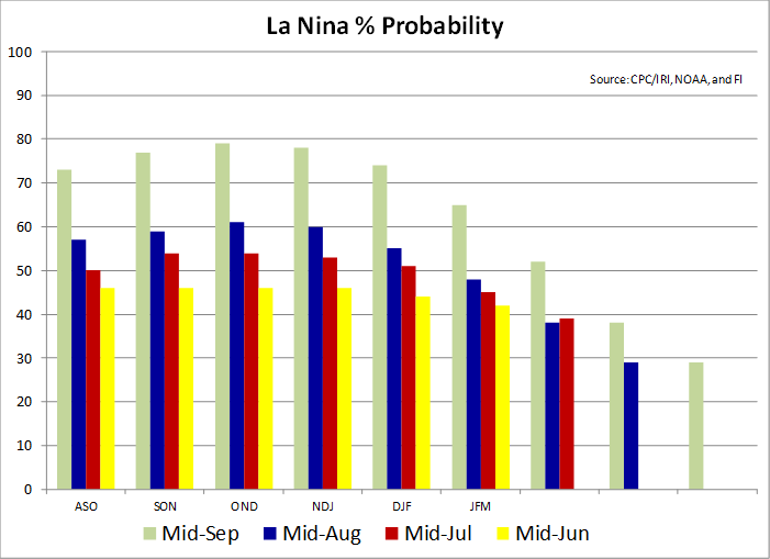
Southern
Oscillation Index was +9.01 today and it will stay significantly positive into next week
Source:
World Weather Inc.
- USDA
weekly corn, soybean, wheat export inspections, 11am - U.S.
crop conditions, harvesting progress for soybeans, corn, cotton, 4pm - EU
weekly grain, oilseed import and export data - Ivory
Coast cocoa arrivals - Malaysia
Sept. 1-20 palm oil export data - HOLIDAY:
Japan
TUESDAY,
Sept. 22:
- U.S.
cold storage data – pork, beef, poultry, 3pm - HOLIDAY:
Japan
WEDNESDAY,
Sept. 23:
- China
customs publishes data on imports of corn, wheat, sugar and cotton - EIA
U.S. weekly ethanol inventories, production, 10:30am
THURSDAY,
Sept. 24:
- USDA
weekly crop net-export sales for corn, soybeans, wheat, cotton, pork, beef, 8:30am - Port
of Rouen data on French grain exports - Brazil’s
Unica to release cane crush and sugar output data during the week (tentative) - USDA
data on hogs and pigs inventory, red meat production, poultry slaughter, 3pm - International
Grains Council monthly report
FRIDAY,
Sept. 25:
- ICE
Futures Europe weekly commitments of traders report, 1:30pm (6:30pm London) - CFTC
commitments of traders weekly report on positions for various U.S. futures and options, 3:30pm - China
customs publishes country-wise soybean and pork import data - S&P
Platts Sugar and Ethanol Conference, Sao Paulo - FranceAgriMer
weekly update on crop conditions - Malaysia
palm oil export data for Sept. 1-25 - U.S.
cattle on feed, 3pm
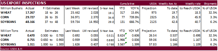
USDA
inspections versus Reuters trade range
Wheat
469,939 versus 450000-700000 range
Corn
755,111 versus 650000-900000 range
Soybeans
1,310,854 versus 1000000-1580000 range
GRAINS
INSPECTED AND/OR WEIGHED FOR EXPORT
REPORTED IN WEEK ENDING SEP 17, 2020
— METRIC TONS —
————————————————————————-
CURRENT PREVIOUS
———–
WEEK ENDING ———- MARKET YEAR MARKET YEAR
GRAIN 09/17/2020 09/10/2020 09/19/2019 TO DATE TO DATE
BARLEY
0 0 0 5,727 3,036
CORN
755,111 939,113 235,389 1,966,144 1,130,528
FLAXSEED
0 0 24 389 72
MIXED
0 0 0 0 0
OATS
48 0 499 996 798
RYE
0 0 0 0 0
SORGHUM
71,452 141,268 6,276 245,816 85,675
SOYBEANS
1,310,854 1,625,688 926,271 3,567,160 2,168,234
SUNFLOWER
0 0 0 0 0
WHEAT
469,939 692,422 488,647 8,624,311 8,018,650
Total
2,607,404 3,398,491 1,657,106 14,410,543 11,406,993
CROP
MARKETING YEARS BEGIN JUNE 1 FOR WHEAT, RYE, OATS, BARLEY AND
FLAXSEED;
SEPTEMBER 1 FOR CORN, SORGHUM, SOYBEANS AND SUNFLOWER SEEDS.
INCLUDES
WATERWAY SHIPMENTS TO CANADA.
-
December
corn dropped by a large 8.75 cents on widespread commodity selling and favorable weather promoting corn harvesting this week for the US. Rain delays will occur to harvesting in the Delta and southeastern states later this week due to remnants of Tropical
Storm Beta, but the rest of the country will see mostly dry weather. The
USD was about 74 higher as of 1:45 PM CT and WTI down $1.77. The passing of Supreme court justice Ruth Bader Ginsburg had markets in fear that a nomination to replace her with be looked as a potentially detrimental action by the current President.
-
Funds
sold an estimated net 35,000 corn contracts. -
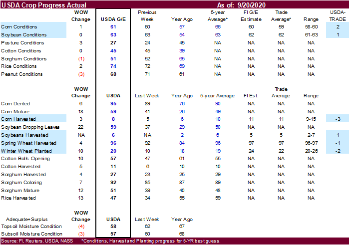
USDA
reported corn conditions at 61 points for the combined good and excellent categories from 60 percent last week and 57 last year and 66 average. The trade was looking for a one-point decrease.

-
US
corn harvest progress was reported at 8 complete from 5 percent previous week, 6 year ago and compares to 10 percent average. The trade was looking for 11 percent. 95 percent of the crop was dented and 59 percent mature (49 average).
-
USDA
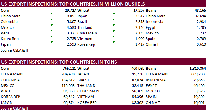
US corn export inspections as of September 17, 2020 were 755,111 tons, within a range of trade expectations, below 939,113 tons previous week and compares to 235,389 tons year ago. Major countries included China Main for 204,498 tons, Colombia for 134,812
tons, and Mexico for 115,063 tons. -
Ukraine
grain stocks as of September 1 were 17.2 million tons, 4 million less than the same period year ago. Ukraine exported 10.48 million tons of grain since July 2020, compared with 12.19 million tons at the same point previous season. -
German
breeding piglet prices are down sharply since the discovery of ASF. They went from 40 euros/piglet to around 27.
-
(Reuters)
– A further seven cases of African swine fever (ASF) have been confirmed in wild boar in the eastern German state of Brandenburg, Germany’s federal agriculture ministry said on Monday. The new cases follow 13 others confirmed in wild boar, not farm animals,
the ministry said. The new discoveries bring total confirmed cases to 20 since the first one on Sept. 10.
None
reported
Source:
Trade News Service.
-
December
is seen in a $3.40-$3.85 range. 2020-21 to average $3.75 for corn and $2.85 for oats.