PDF Attached
Is
weather a mess? We think it’s starting to sink in for Northern Hemisphere winter grain producers (Black Sea and US) and late developing summer grains (China storms). Supply is an issue for oilseeds after Brazil oversold their soybean crop. Two-sided trade
today, with soybean meal leading the charge higher for soybeans, corn and wheat. News was light. The trade remains focused on Chinese corn and soybean buying of US and new crop Brazil. US equities were lower while the USD also traded lower by US afternoon
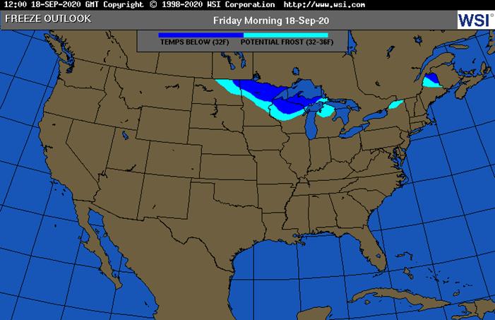
and crude WTI was higher. US is starting to cool only to warm up after the weekend. Freeze ending US growing season will be a reality by the end of the month.
TROPICAL
COMMENTS
- Tropical
Disturbance in the western Gulf of Mexico will likely become the next tropical depression and it may threaten Mexico and/or the United States during the weekend or next week - Most
forecast models have the storm meandering around in the western Gulf of Mexico For days before threatening land - Tropical
Storm Sally diminished to depression status overnight and was nearing the Alabama/central west Georgia border this morning - The
storm center was 50 miles southeast of Montgomery, Alabama - Sally
will move across central Georgia and into the Carolinas today and Friday while slowly diminishing further - Additional
rainfall of 1.00 to 4.00 inches and locally more (to 6.00 inches) is expected which may cause localized flooding, but the storm’s greatest wind and rain have diminished enough to minimize the risk of damage - Sally
has damaged crops and property across the western Florida Panhandle and in southern Alabama, but the assessments are incomplete and it will be a few days before the extent of the damage is known - Rain
totals of 10 to more than 20 inches occurred in in the Florida Panhandle while amounts of 4.00 to 10.00 inches occurred northward into southern Alabama mostly along the Interstate 65 corridor and east to the Georgia border - These
areas also experienced the strongest wind speed of 40-60 mph - Some
higher wind speeds occurred near the Mobile Bay area of Alabama where speeds of 60 to 100 mph occurred as the storm came inland - Hurricane
Paulette lost its topical characteristics over open water in the northern Atlantic Ocean Wednesday - Tropical
Storm Vicky was expected to dissipate by Saturday over open water in the central Atlantic Ocean - Hurricane
Teddy, however, was expected to become a Category 3 hurricane equivalent storm over open water in the central Atlantic Ocean later today and Friday before moving toward Bermuda during the weekend - Teddy
may pass very near or slightly to the east of Bermuda early next week as a Category 2 storm after that the storm may threaten Nova Scotia and Newfoundland, Canada with heavy rain and high wind speeds - A
tropical wave south southwest of the Cabo Verde Islands will move toward the Leeward Islands in the Atlantic Ocean over the next several days - This
system may become a tropical depression, but there is not much support for a stronger storm as the environment it moves into this weekend becomes a little hostile for further development - Tropical
Storm Noul is still moving toward central Vietnam, but the system is no longer advertised to reach typhoon status and that may help the system have a lower impact from central Vietnam to northeastern Thailand - The
system will stay north of the key Central Highlands production region, although some rain from the storm will impact a part of coffee country without damage - Landfall
is expected around 0600 GMT Friday to the north of Hue, Vietnam - Torrentially
rain and flooding will accompany the storm inland - Crop
damage will be low because the area impacted is not a very important rice production area - Tropical
Disturbance well south of Hawaii has some potential to develop into a tropical cyclone over the next few days, but it will move west northwesterly and stay far to the south of the Hawaiian Islands - Tropical
Depression Karina was dissipating over open water well to the west of Mexico today
OTHER
WORLD WEATHER ISSUES
- Dryness
continues to threaten winter crop planting and establishment in the drier areas of southeastern Europe, central and eastern Ukraine, western Kazakhstan and parts of Russia’s Southern Region - No
relief from drought will occur in these areas for another ten days, but conditions may begin to improve in early October - France,
the United Kingdom, Spain and Portugal will receive rain this weekend and during much of next week resulting in some improved topsoil moisture - More
rain will be needed, but the precipitation will help to improve pre-planting and early planting moisture for autumn crops - Germany
will receive some rain in the second half of next week and that will help ease recent drying - Parts
of Italy will also receive rain during mid- to late-week next week and some of this moisture may begin to push into southeastern Europe during the second weekend of the two week outlook - Western
portions of Western Australia will receive some rain during mid- to late-week next week, but interior crop areas may not get much moisture for a while - Net
drying in northern parts of Western Australia’s wheat and barley production region may be cutting into yields as reproduction is under way - Southern
and western crop areas will get just enough moisture to maintain a good production outlook - Australia’s
crop areas from South Australia to Queensland, New South Wales and Victoria will get needed rain by Sunday and sufficient amounts will occur to support better winter crop conditions - Additional
rain will still be needed to restore soil moisture after prolonged drought in South Australia, Queensland and some western and northern New South Wales crop areas, but crops will certainly benefit from the moisture - South
Africa still needs significant rain for its winter wheat, barley and canola crops, especially those in eastern production areas - Not
much rain is expected over the coming week, although a few sporadic showers are anticipated - Argentina’s
drought in the west will not be altered over the next week to ten days - Rain
is expected in northeastern parts of the nation benefiting future cotton, corn and sunseed planting and supporting a little citrus flowering
- Temperatures
will be near average over the coming week and a little colder than usual in the last days of September - Center
West and southern parts of center south Brazil are advertised to receive scattered showers and thunderstorms Sep. 20-23 with some follow up rain periodically into the end of this month - The
precipitation might eventually help lift topsoil moisture for “some” early season soybean planting, but much more rain will be needed - Coffee
and citrus flowering “may” occur in a few areas from northeastern Sao Paulo into southern Minas Gerais and Rio de Janeiro while sugarcane and early corn experience a moisture boost to improve crop development; however, most of the region will fail to get quite
enough moisture to make big changes in crop or soil conditions without follow up moisture - Southern
Brazil rice, corn and wheat areas will get periodic rainfall through the next two weeks - Crop
and field conditions will either improve or continue good through the end of this month - China
rain Wednesday became widespread again in the Northeast Provinces reversing the drying trend of the past few days - Rain
totals varied from 0.20 to 1.00 inch with one amount of 1.69 inches - Most
of the Yellow River Basin and North China Plain was left dry - Rain
fell significantly again in the Yangtze River Basin where amounts ranged from 1.00 to 4.00 inches and local totals to 6.00 inches - Net
drying occurred in the southern coastal provinces - China
rainfall the past three days from extreme southeastern Sichuan and Guizhou through southeastern Hebei to parts of southern Anhui has ranged from 4.00 to 13.31 inches resulting in some flooding once again - China
weather over the next two weeks - Rain
will continue to impact portions of Heilongjiang and Jilin frequently over the next week to ten days resulting in further delays to crop maturation and harvesting through the balance of this month; some crop quality declines are expected to continue especially
for soybean, rice and some groundnuts - A
good mix of rain and sunshine will impact the middle and lower Yellow River Basin and portions of the North China Plain over the next ten days resulting in relatively good summer crop maturation and harvest conditions while improving future wheat planting
potentials - Rain
will fall frequently in the Yangtze River Basin and southern coastal provinces as well as Yunnan and Guangxi during the next two weeks to maintain soggy field conditions - The
wettest conditions will shift south of the Yangtze River reducing the risk of more serious flooding in the Yangtze River Basin once again - Much
of eastern China needs to dry down in support of summer crop maturation and harvesting as well as support for winter crop planting that occurs from late this month through October and into November - Xinjiang,
China weather will continue favorable for cotton and other crop maturation and early harvest progress - Alternating
periods of warm and cool weather will occur through the next ten days with restricted rainfall expected - The
environment will support crop maturation, leaf defoliation and early harvesting - High
temperatures Wednesday were in the 70s Fahrenheit northeast and 80s southwest followed by lows today in the upper 40s and 50s - India
weather over the next two weeks will continue wettest in central, southern and far eastern parts of the nation while net drying occurs in the north - Monsoonal
precipitation will continue without much withdrawal through early next week, but a more significant withdrawing trend is expected in the last week of September and early October improving crop maturation conditions in central parts of the nation
- Weather
conditions in most of India are still favorable, but drying is needed in Gujarat and that may not come for another week - U.S.
weather over the next ten days - Favorable
summer crop maturation and harvest weather is expected due to restricted rainfall and mild to warm temperatures for the next ten days including the Midwest Corn and Soybean Belt - Southeastern
U.S. rainfall will be winding down after today and Friday with a developing drier bias expected during the weekend and during much of next week - The
change will result in better conditions for summer crops not seriously impacted by Tropical Cyclone Sally - U.S.
hard red winter wheat areas will receive limited rainfall which may be good for summer crop maturation and harvest progress - Wheat
planting and emergence will continue, although there is need for greater rain to induce better emergence and establishment in the driest areas - The
bulk of additional planting will occur in October - West
Texas rainfall will be limited enough to support favorable crop maturation
- Northern
Plains will receive restricted rainfall and experience warm temperatures favoring a good crop maturation and harvest environment - U.S.
temperatures will slip to the frost and freeze threshold in the upper Midwest and northern Great Lakes region late this week again tonight with lows in the 30s Fahrenheit and with a few colder readings near the Canada border - Some
extreme lows in the upper 20s occurred this morning in northern Minnesota, but key crop areas in the Midwest were not experiencing temperatures nearly as cold - Some
frost and a few more light freezes will occur in northern Minnesota and the western Great Lakes region Friday morning - Overall
temperatures in the coming week will be warmer than usual from the central and northwestern Great Plains through most of the western states while near to below average farther to the east - The
coolest conditions relative to normal through the weekend will be in the eastern Midwest through the Atlantic Coast states - Temperatures
next week will be similar to those of this week, although a little warmer in the eastern Midwest and a little milder in the central Plains - Some
minor cooling is also expected in the Pacific Northwest and Rocky Mountain region - U.S.
NWS forecast for October suggests above average rainfall for most of the contiguous United States excepting the Pacific Northwest where there was an equal chance for above, below and near normal temperatures - Rainfall
for October was advertised to be lighter than usual in the central and southern Plains, southern Rocky Mountain region and from the lower Midwest into the Delta - Wetter
than usual conditions were advertised for Florida and in the Pacific Northwest - US
NWS Forecast for October through December was warmer than usual for the entire contiguous United States - Precipitation
was advertised to be below average from the southwestern desert region through the southern Rocky Mountain region and southern half of the Great Plains to the Delta and Alabama - Precipitation
was advertised to be greater than usual in the Pacific Northwest and much of Montana as well as northwestern Wyoming - Other
areas had equal chances for above, below and near normal precipitation - West-central
Africa will continue to experience periodic showers and thunderstorms over the next couple of weeks - Additional
improvement is expected to coffee, cocoa, rice and sugarcane production areas after rain fell significantly during the weekend - The
next wave of greatest rain will occur next week - Cotton
areas will also continue to receive some rain for a while longer - All
crops receiving rain will likely benefit from the moisture - East
central Africa rainfall has been and will continue to be erratic and mostly beneficial over the next ten days - Canada
Prairies will experience some weekend rain, but good harvest weather is expected prior to and after that period of time for a few days - Additional
rainfall is expected in the last week of this month - Harvesting
and crop maturation should advance relatively well during the period with only a few delays likely - Mainland
areas of Southeast Asia will experience periodic showers and thunderstorms over the next couple of weeks
- Late
season moisture boosting is extremely important since water supply has not been fully restored from last year’s low levels - Tropical
Storm Noul will attempt to bring significant rain to the region from central Vietnam into northeastern Thailand Friday through Sunday - Philippines
rainfall increased recently from Tropical Storm Noul, but more rain is still needed in the Visayan Islands - Improving
rainfall in Indonesia and Malaysia is expected over the next two weeks with some heavy rain possible in random locations - Ontario
and Quebec rainfall will occur periodically over the next ten days alternating with periods of rain and sunshine - Net
drying is expected during much of this first week of the outlook - Temperatures
will be seasonable to slightly cooler than usual -
New
Zealand rainfall will be above average on the west coast of South Island and below average elsewhere; temperatures will be near to below average -
Southern
Oscillation Index was +10.24 today and it will stay significantly positive into next week
Source:
World Weather Inc.
- USDA
weekly crop net-export sales for corn, soybeans, wheat, cotton, pork, beef, 8:30am - USDA
total milk production for August, 3pm - Port
of Rouen data on French grain exports - Biosev
SA 1Q 2021 earnings
FRIDAY,
Sept. 18:
- ICE
Futures Europe weekly commitments of traders report, 1:30pm (6:30pm London) - CFTC
commitments of traders weekly report on positions for various U.S. futures and options, 3:30pm - FranceAgriMer
weekly update on crop conditions
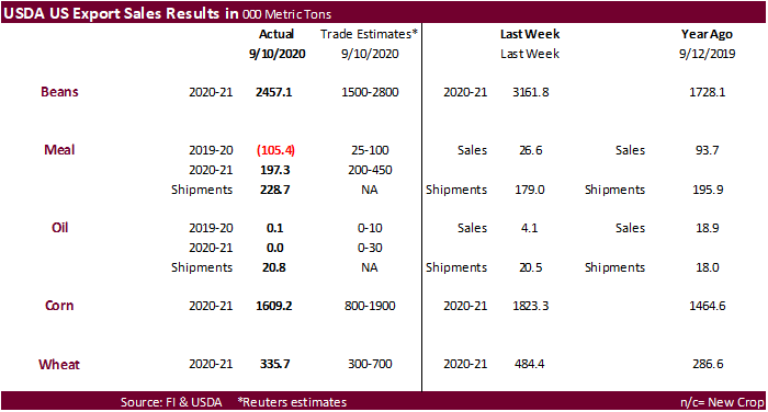
USDA
export sales
Good
sales posted again for the major commodities, although soybeans, corn, and wheat are down from the previous week. Meal and oil shipments were ok.
Macros
US
Initial Jobless Claims Sep 12: 860K (est 850K; prevR 893K; prev 884K)
US
Continuing Claims Sep 5: 12628K (est 13000K; prevR 13544K; prev 13385K)
US
Philly Fed Business Outlook Sep: 15.0 (est 15.0; prev 17.2)
US
Housing Starts Aug: 1416K (est 1483K; prev 1496K)
US
Housing Starts (M/M) Aug: -5.1% (est -0.9%; prev 22.6%)
US
Building Permits Aug: 1470K (est 1512K; prevR 1483K; prev 1495K)
US
Building Permits (M/M) Aug: -0.9% (est 2.0%; prevR 17.9%; prev 18.8%)
-
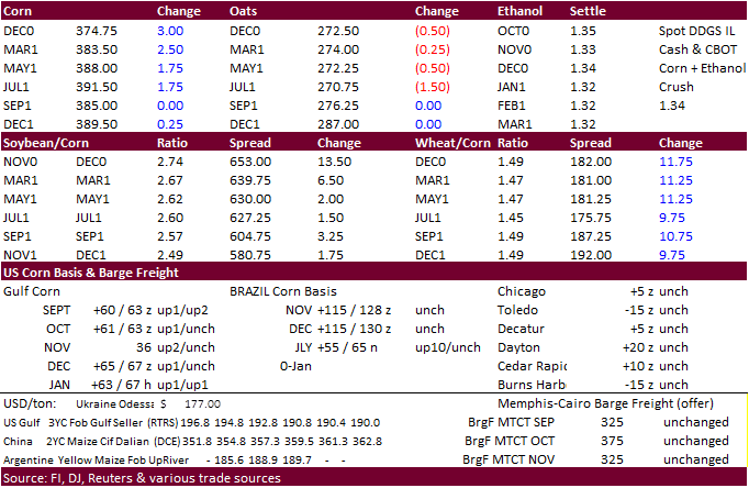
CBOT
corn saw
a two-sided trade considering the overnight session and ended higher
as traders continue to figure out if China buying will continue at its current robust pace.
Corn is at a six-month high. USDA announced additional sales after the electronic pause and the trade took note. Speculation China will become a massive corn buyer in 2021 continues to circulate. US CIF corn appreciated 5-7 cents from this time last week.
-
Funds
bought an estimated net 1,000 contracts. -
USD
was down 30 points and WTI crude oil up $0.92 as of 2:30 PM CT. -
China
set their TRQ’s for 2021 at the same levels as this year of 7.2MMT for corn and 9.6MMT for wheat.
-
Wheat
quota set at 9.636m tons; 90% allocated to state-owned firms -
Corn
quota at 7.2m tons, of which 60% is for state-owned companies -
Rice
quota set at 5.32m tons, and 50% for state-owned entities -
Cotton
quota at 894,000 tons, 33% for state-owned firms -
China
Dalian corn futures margin requirements for hedging and speculative trading increased to 7% and 8% respectively.
-
(Reuters)
– The Trump administration is considering at least $300 million in cash aid to U.S. oil refiners that are denied exemptions to U.S. biofuel blending laws for the 2019 compliance year, two sources familiar with the matter said. -
Kazakhstan
reported seven outbreaks of H5 bird flu near the Russian border. -
Germany
confirmed one more ASF case from a wild boar. Pork prices plunged last Friday but stabilized this week.
-
Under
the 24-hour announcement system, USDA announced private exporters sold:
-
Export
sales of 120,000 tons of corn for delivery to unknown destinations during the 2020/2021 marketing year
China
corn futures vs. US
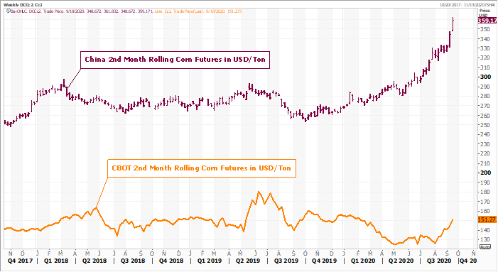
Source:
Eikon and FI
-
December
is seen in a $3.40-$3.85 range. 2020-21 to average $3.75 for corn and $2.85 for oats.