PDF Attached
Calls:
Corn
steady
Soybeans
steady lower
Wheat
steady
US
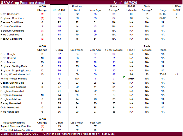
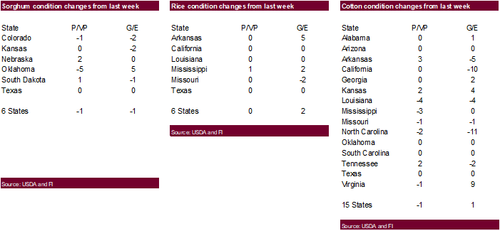
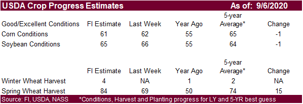
CORN – 61 PCT CONDITION GOOD/EXCELLENT VS 62 PCT WK AGO (55 PCT YR AGO) -USDA
US
CORN – 97 PCT DOUGH VS 94 PCT WK AGO (94 PCT 5-YR AVG) -USDA
US
CORN – 79 PCT DENTED VS 63 PCT WK AGO (71 PCT 5-YR AVG) -USDA
US
CORN – 25 PCT MATURE VS 12 PCT WK AGO (19 PCT 5-YR AVG) -USDA
US
SOYBEAN – 65 PCT CONDITION GOOD/EXCELLENT VS 66 PCT WK AGO (55 PCT YR AGO) -USDA
US
SOYBEANS – 20 PCT DROPPING LEAVES VS 8 PCT WK AGO (16 PCT 5-YR AVG) -USDA
US
RICE – 78 PCT CONDITION GOOD/EXCELLENT VS 76 PCT WK AGO (69 PCT YR AGO) -USDA
US
WINTER WHEAT – 5 PCT PLANTED (1 PCT YR) (3 PCT 5-YR AVG) -USDA
US
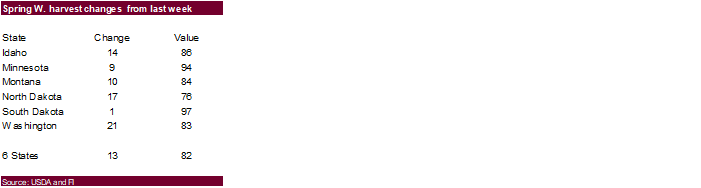
SPRING WHEAT – 82 PCT HARVESTED VS 69 PCT WK AGO (87 PCT 5-YR AVG) -USDA
US
RICE – 26 PCT HARVESTED VS 20 PCT WK AGO (35 PCT 5-YR AVG) -USDA
US
COTTON – 45 PCT CONDITION GOOD/EXCELLENT VS 44 PCT WK AGO (43 PCT YR AGO) -USDA
US
COTTON – 37 PCT BOLLS OPENING VS 29 PCT WK AGO (34 PCT 5-YR AVG) -USDA
US
COTTON – 96 PCT SETTING BOLLS VS 93 PCT WK AGO (97 PCT 5-YR AVG) -USDA
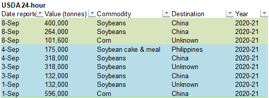
USDA
reported private exporters sold:
Export
sales of 400,000 metric tons of soybeans for delivery to China during the 2020/2021 marketing year; and
Export
sales of 264,000 metric tons of soybeans received during the reporting period for delivery to China during the 2020/2021 marketing year; and
Export
sales of 101,600 MT of corn for delivery to unknown destinations during the 2020/2021 marketing year.
Crude
oil was down sharply as the Suadi’s have said they will cut oil prices and the USD was up 73 points as of 2:30 pm CT.

MORNING
WEATHER MODEL COMMENTS
KEY
ISSUES OF THE DAY
- U.S.
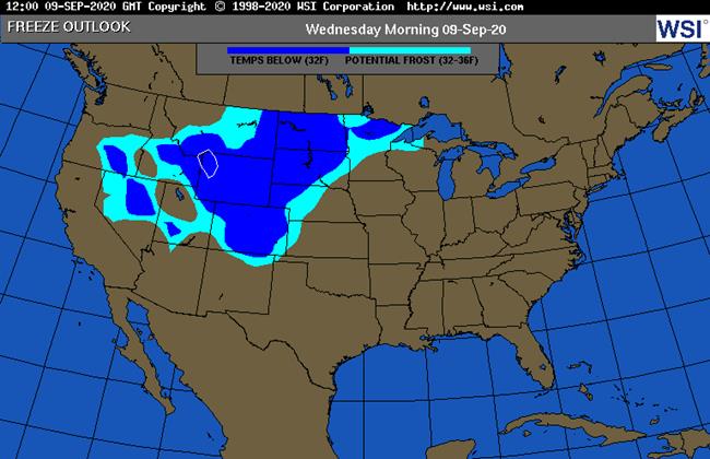
northern Plains and Canada’s Prairies experience freezes this morning - Some
damage to immature crops resulted - Freezes
will occur Wednesday morning from Manitoba and far northern Minnesota through North Dakota to Montana and from Wyoming to western Nebraska and eastern Colorado - Damage
to dry edible beans and sugarbeets are expected along with some immature summer crops in the west-central Plains - Livestock
stress will be high in eastern Colorado and some immediate neighboring areas today and Wednesday due to cold rain and wet snow - Remnants
of Typhoon Haishen have produced more heavy rain in northeastern China where the ground is already too wet and flooded from Typhoon Maysak that moved through the region last week - Western
Argentina remains too dry with little change likely, although rain will fall in southern and northeastern Argentina over the coming week - Dryness
in Europe will continue from France to Ukraine this week which will be good for summer crop maturation and harvesting and for planting of some winter crops - Drought
remains a concern for France, the middle and lower Danube River Basin, central and eastern Ukraine, Russia’s Southern Region and western Kazakhstan – little relief expected this week - Flooding
remains a concern for northeastern China’s corn and soybean country; the region must dry out for summer crop harvest – some damage to crops has likely occurred - Australia
still needs significant rain to support reproduction in Queensland, northern New South Wales and northern parts of Western Australia - Mexico
and Central America have trended much wetter recently and the trend will continue; relief from dryness in Honduras and Nicaragua is becoming more complete - West-central
Africa remains too dry especially in Ghana and eastern coffee and cocoa production areas of Ivory Coast - Rain
in South Africa during the weekend was good for wheat, barley and canola, but much more was needed
MORE
DETAILS FOR THE WORLD
- North
America Cold Surge Overnight Stresses Livestock And Damages Crops - Unseasonable
cold settled through the Canadian Prairies and into the northern U.S. Plains overnight inducing some crop damage and more is expected tonight - Extreme
lows slipped to the 20s Fahrenheit in Montana and parts of Canada’s Prairies with a few upper teens noted as well.
- Freezes
will occur Wednesday and parts of Montana to northern Minnesota and from Wyoming into western South Dakota, western Nebraska and northeastern Colorado
- Damage
is expected to dry edible beans, sugarbeets, potatoes and some heavily irrigated late season crops
- Dryland
crops will not be as seriously impacted because of heat and dryness in recent weeks has already advanced crops to maturity at the potential expense of yield - Damage
in Canada will include some flax, corn and soybeans as well as a few late season canola crops in Saskatchewan and Manitoba - Livestock
stress will be greatest from Montana to western Kansas and eastern Colorado due to falling temperatures, high wind speeds, cold rain and heavy wet snow - The
moisture will be good in easing long term dryness, although more rain will still be needed - Winter
wheat planting may improve in early seeding areas due to the moisture boost expected - North
America Cold Surge Will Not Seriously Harm U.S. Midwest Corn Or Soybeans - Low
temperatures this morning in the eastern Dakotas, Minnesota and northwestern Iowa were not low enough to cause harm to summer crops
- Wednesday
low temperatures will fall to the 30s in the eastern Dakotas and western and northern Minnesota
- Most
freezes and frost will occur in northern and western Minnesota and eastern North Dakota with very few temperatures below 30 Fahrenheit - Some
crop damage is expected, but no serious production cut will result - Crop
quality issues will be possible - Cloud
cover will be widespread in western Midwest Wednesday except northwestern Minnesota and North Dakota – which holds temperatures up - Cold
air will be moderating by Thursday, but cloud cover will still be abundant in western Corn Belt except northern Minnesota, North Dakota and a few immediate neighboring areas which will prevent frost and freezes once again
- Clouds
will still be present Friday when most lows in the western Midwest will be in the 40s
- None
of North America threatening cold will reach into eastern Midwest, Delta or southeastern U.S. - Southwest
U.S. Plains And West Texas Will Experience No Freezes - Rain
and cloudiness will accompany cold air into southwest U.S. Plains helping to hold temperatures up above the damage threshold
- Rain
falls today through Thursday with some showers Friday in the southwestern Plains bolstering soil moisture for better wheat planting and emergence conditions and improving soil moisture in sorghum, cotton, peanut and corn production areas - Cotton
boll lock is possible in some of the production areas of West Texas and areas north into southwestern Kansas because of High temperatures Wednesday and Thursday in the 50s and 60s with a few 40s and lows in the upper 30s and 40s Wednesday and Thursday with
40s continuing Friday - Frost
may be avoided because of cloudiness throughout the cold period - Warming
will return late this week and into the weekend with highs back into the 70s and 80s throughout the southwestern Plains and lows in the 50s and lower 60s - Heavy
wet snow from Colorado to Wyoming may bring trees and powerlines down tonight into Wednesday morning - Many
deciduous trees have not lost their leaves yet - Notable
transportation delays are expected, although the snow will melt relatively quickly after falling on streets and highways - Substantial
early season snowfall is expected in the mountains of Wyoming and Colorado - U.S.
hard red winter wheat areas will get a general soaking of rain this workweek (with snow in Colorado during mid-week) that will dramatically improve soil moisture for future wheat planting and establishment - Moisture
totals of 0.60 to 1.50 inches west and 1.00 to 2.50 inches east with a few greater amounts possible in Oklahoma and south-central Kansas - Drier
weather will evolve this weekend and last through most of next week - Temperatures
will trend colder this workweek and then warmer this weekend through next week with temperatures back above average next week.
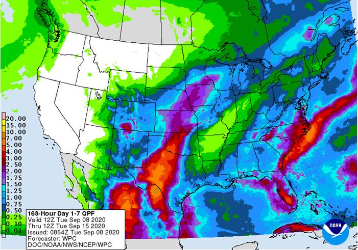
- Western
U.S. Corn Belt will get some needed rain to ease long term dryness in Iowa and neighboring areas this week - Rainfall
of 0.40 to 1.50 inches will occur in the far northwest while 1.00 to 3.00 inches and a few totals over 6.00 inches from the eastern Texas Panhandle into south-central Kansas
- Northeastern
North Dakota and parts of northern Minnesota rainfall will be minimal this week while rain falls in most other western Corn Belt locations with totals of 0.50 to 1.50 inches resulting - Rainfall
will be much more limited this weekend into next week with only one frontal system and associated rain occurring Sep. 18-19 - Moisture
comes too late for a serious increase in late season crop yields, but the moisture will stop the decline in crop conditions - Lower
Eastern U.S. Midwest and northern Delta rainfall will be restricted next ten days with less than 0.50 inch of moisture expected which will lead to net drying - Rainfall
in Great Lakes region will vary from 0.60 to 1.50 inches and locally more over the coming ten days - U.S.
lower Delta and southeastern states will experience routinely occurring rainfall over the next ten days with the southeastern states wettest - The
lower Delta will not get much rain until this weekend and then a daily occurrence is possible next week - Tropical
Storm Paulette was over open water in the central Atlantic Ocean and will stay over open water through the next week posing no threat to land - Paulette
was located 1250 miles west of Cabo Verde Islands or 1330 miles east of the Northern Leeward Islands at 18.1 north, 42.8 west at 0500 EDT today moving northwesterly at 6 mph
- Tropical
storm force wind was noted out 70 miles from the storm center - The
storm will intensify, but stay a minimal threat to land - Tropical
Storm Rene formed Monday and was 55 miles southwest of Santo Antao, Cabo Verde Islands this morning at 16.5 north, 25.7 west moving west northwesterly at 15 mph and producing maximum sustained wind speeds of 40 mph.
- The
storm will slowly strengthen as it moves away from the Cabo Verde Islands today through the end of this week - The
storm will remain over open water in the Atlantic Ocean posing no threat of any other landmass
- The
storm may become a Hurricane later in the week - Tropical
Wave southwest of Bermuda may move to the U.S. Carolina Coast Thursday - Some
development is possible into a tropical depression, although confidence is low for now - Tropical
Storm Haishen reached northeastern China Monday and moved inland through eastern South Korea earlier in the weekend before reaching China - The
storm reached South Korea as a Category Two storm, but may have been a little less impactful than Typhoon Maysak was earlier last week - Nevertheless,
heavy rain was noted and storm strong wind and the additional moisture over already saturated and flooded land may have caused more damage to crops and property - Rainfall
through dawn today ranged from 1.00 to 6.00 inches in northeastern China and additional rainfall of 1.00 to 3.00 inches and locally more will occur through Wednesday causing greater flooding and more potential crop damage - Canada
Prairies rainfall during weekend was greatest in southern and northeastern Prairies with up to 1.00 inch in southern Alberta and up to 0.62 inch in northern Manitoba and 0.43 inch northeastern Saskatchewan - Some
harvest delay occurred because of rain, but other areas were dry and fieldwork advanced well - Weekend
temperatures were very warm initially with highest readings in the 80s and lower 90s, but much cooler conditions occurred today with afternoon temperatures struggling to stay in the 40s and 50s Fahrenheit - Canada
Prairies will experience dry and warmer weather the remainder of this week after overnight damaging cold - Some
additional frost and light freezes will occur tonight in Manitoba - Harvest
progress will accelerate - China
rainfall late last week was greatest in eastern Inner Mongolia where rainfall of 1.50 to nearly 5.00 inches resulted from the remnants of Typhoon Maysak - Northern
Heilongjiang also reported rainfall of 0.60 to more than 4.00 inches from the same storm Friday - Rainfall
in northeastern China during the weekend was greatest in Hebei and western Liaoning where up to 2.60 inches resulted, but rainfall Monday ranged from 1.00 to more than 6.00 inches as the remnants of Tropical Storm Haishen impacted the region - Weekend
rain was more significant in southwestern China where Guizhou and Hunan reported 3.50 inches to nearly 5.00 inches with one location in Hunan reporting 8.40 inches. Rain also fell in the southern coastal provinces of Guangdong and Fujian where amounts varied
from 1.34 to 4.20 inches with one location reporting nearly 9.69 inches - Net
drying occurred in east-central China where temperatures reached into the lower and a few middle 90s Fahrenheit inducing aggressive drying - East-central
China will continue dry over the next ten days especially in central Yellow River Basin
- Rain
is expected periodically to the northeast and in the southwest - Rainfall
in the southwest will vary from 3.00 to more than 10.00 inches resulting in some flooding from southern Sichuan, Guizhou and Yunnan to Guangdong and Fujian - Rainfall
in the northeast part of the nation occurs mostly into Wednesday from the dissipating Tropical Storm Haishen
- Additional
rainfall of 1.00 to 3.00 inches and locally more will occur perpetuating flood conditions - Flooding
in northeastern China has become a concern for summer crop maturation and harvesting and drying is needed immediately to protect crops from additional potential damage - Rain
will fall into Wednesday from the remnants of Haishen and then a few days of drying occurs before an upper level low pressure center pushes across the region next week generating multiple days of rainfall
- Argentina
weather the past few days was mostly dry, although up to 1.14 inches occurred in northeastern La Pampa through dawn today
- Southern
Argentina will receive a few more light showers during mid- to late week this week, but the impact on soil moisture and crop conditions will be low - Moisture
totals will vary from 0.05 to 0.35 inch except near the Buenos Aires south coast where rainfall may range from 0.50 to 1.50 inches - Northeastern
Argentina will get some rain late this week benefiting a few grain and cotton areas with follow up rain in the same area during mid- to late-week next week - There
is still no relief expected for the drought areas of western Argentina during the coming ten days - Brazil
weekend rainfall was minimal except in Rio Grande do Sul and Santa Catarina where moisture totals of 0.68 to 1.34 inches resulted - Temperatures
were hot in center west crop areas with readings in the middle 90s to 104 degrees Fahrenheit - Brazil
rainfall will continue greatest in the far south of the nation for at least the next ten days - Rain
is advertised from Parana to southern Minas Gerais Sep 21-23, but the event is too far out in time to have much confidence - The
moisture would reach into some citrus, sugarcane and coffee production areas and might be good for early corn, but early indications suggest only light rain - Center
west Brazil looks to be dry and very warm to hot through Sep. 23 - South
Africa weekend rainfall was scattered lightly in the central and west benefiting some wheat, barley and canola areas, although more rain is needed - Amounts
were greatest from southeastern Northern Cape into north-central Eastern Cape where 0.72 to 1.57 inches resulted - Most
rain totals were under 0.40 inch - All
of it was welcome more was needed - South
Africa will be mostly dry this week except in a few coastal areas - More
rain is needed to support winter crop development and improve soil moisture for spring and summer crop planting next month - West-central
Africa rainfall was erratic during the weekend - Western
parts of Ivory Coast received 0.30 to 3.46 inches, but all other coffee and cocoa production areas from eastern Ivory Coast through Ghana were left dry - Erratic
rainfall is expected to continue in these areas for a while, but as the middle of September arrives the precipitation should increase - Rain
is needed in both nations, but probably more so in Ghana - Western
CIS precipitation during the weekend was limited to western Russia, Belarus, the Baltic States and the eastern most New Lands where moisture totals varied from 0.50 to 1.34 inches with a few amounts in western Russia getting up to 1.77 inches - Eastern
Russia New Lands will dry down briefly late this week and into the weekend, but more rain is expected next week - The
break from frequent rain will be welcome, but possibly not long enough to get aggressive harvesting to take place - A
little concern over spring wheat quality remains in West Siberia and - Western
Russia precipitation will occur frequently this week along with the Baltic States, parts of Belarus and the Ural Mountains region (later this week) - The
moisture will slow crop maturation and may delay fieldwork in a few areas, but some harvest progress is expected - Early
season planting of winter crops is advancing favorably - Dryness
is prevailing from eastern Ukraine into Kazakhstan and very little change is expected for at least ten days - Europe
weather during the weekend occurred from northern Italy to Poland and the Baltic States during the weekend
- Moisture
totals varied from 0.30 to 1.36 inches - Mostly
dry weather occurred elsewhere - Temperatures
were mild in the north and warm in the south - Europe
precipitation will be restricted this week leaving France, parts of Germany and the middle and lower Danube River Basin quite dry and in need of significant rain - Western
Europe may trend wetter next week - Temperatures
will be warmer than usual this week - Australia
weather during the weekend included rain in southwestern parts of Western Australia and in east-central New South Wales
- Moisture
totals varied from 0.05 to 0.35 inch with local totals of 1.00 to 2.00 inches near the coast in the far southwest
- Australia
weather over the coming ten days will include some light rainfall over some of the nation’s winter crop region, but most of the rain will be a little too light to seriously bolster soil moisture
- Some
forecast models are increasing rain for New South Wales, Queensland and Victoria after Sep. 18, but confidence is low - Pakistan
weather is improving after flooding in late August - Central
and southern Pakistan was dry during the weekend - Very
little rain will fall over the next ten days - Central
America and western and southern Mexico will continue to experience periodic rainfall through the next two weeks supporting many crops - Wet
weather during the weekend bolstered soil moisture in many areas - Rain
is expected to be abundant during the next two weeks with some needed moisture eventually falling in northeastern Mexico and southern Texas - Ontario
and Quebec will experience a good mix of rain and sunshine over the next two weeks; some drying will be needed thereafter to induce better crop maturation and harvest conditions -
New
Zealand rainfall will be erratically distributed for a while and temperatures will be a little cooler biased -
Southern
Oscillation Index was +9.35 today and it will stay strongly positive this week
- USDA
weekly corn, soybean, wheat export inspections, 11am - U.S.
crop condition, harvesting progress for soybeans, corn, cotton, 4pm - Malaysian
Palm Oil Council webinar on Middle East, North Africa palm trade - Abares
Australian crop report
WEDNESDAY,
Sept. 9:
- Brazil
Unica cane crush, sugar production (tentative)
THURSDAY,
Sept. 10:
- EIA
U.S. weekly ethanol inventories, production, 10:30am - Malaysian
Palm Oil Board’s end-Aug. palm oil stockpiles, production, export data - Malaysia
palm oil export data for Sept. 1-10 - Conab’s
data on production, area and yield of soybeans and corn in Brazil
FRIDAY,
Sept. 11:
- (Overnight)
China agriculture ministry’s (CASDE) monthly report on supply and demand - USDA
weekly crop net-export sales for corn, soybeans, wheat, cotton, pork, beef, 8:30am - USDA’s
monthly World Agricultural Supply and Demand (Wasde) report, noon - ICE
Futures Europe weekly commitments of traders report, 1:30pm (6:30pm London) - CFTC
commitments of traders weekly report on positions for various U.S. futures and options, 3:30pm - FranceAgriMer
weekly update on crop conditions - New
Zealand food prices
Source:
Bloomberg and FI


Source:
Bloomberg and FI
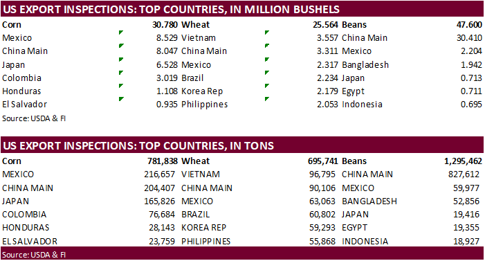
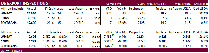
USDA
inspections versus Reuters trade range
Wheat
695,741 versus 450000-700000 range
Corn
781,838 versus 500000-800000 range
Soybeans
1,295,462 versus 650000-1100000 range
Corn.
-
Choppy
session but volume was heavy for corn and soybeans. -
CBOT
corn traded two-sided in part on good rains across the Midwest over the long holiday weekend and good export demand. USDA’s 24-hour corn and soybean announcements underpinned prices after the day session open and the December closed 3.75 cents higher at $3.6175.
-
The
USD was up sharply throughout the session and was up 73 points by 2:30 PM CT. Widespread commodity selling was in play.
-
Brent
crude oil fell below $40/barrel, first time since June 25. -
China
corn futures reached a fresh 5-year high. -
Funds
bought an estimated net 11,000 contracts. -
US
corn crop conditions dropped one point. The trade was looking for a two-point drop.
-
USDA
US corn export inspections as of September 03, 2020 were 781,838 tons, within a range of trade expectations, above 423,765 tons previous week and compares to 612,065 tons year ago. Major countries included Mexico for 216,657 tons, China Main for 204,407 tons,
and Japan for 165,826 tons. -
Europe
will see restricted rainfall this week and temperatures will be above normal. Northeast China will remain flooded from the typhoon that hit the country Tuesday.
-
Agritel
sees the Ukraine corn crop at 33.5 million tons, down 6.5 percent from 2019. A smaller corn crop could boost US corn exports to China through July 2021.
-
Under
the 24-hour system, USDA reported export
sales of 101,600 MT of corn for delivery to unknown destinations during the 2020/2021 marketing year.
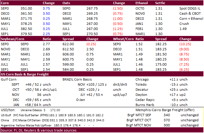
-
December
is seen in a $3.40-$3.85 range.