PDF Attached
Fed
leaves rates steady, sees two small hikes by end of 2023 – Reuters News
Fed
leaves policy rate in 5.00%-5.25% range
Another
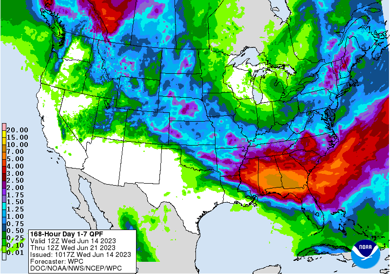
choppy trade as traders mull over supply concerns and sharply lower USD after US PPI data eased economic concerns. US weather outlook hasn’t changed that much. Midday was a little wetter for the Great Plains and drier for parts of the Midwest for the 11-15
day period. Look for rain to increase across the Midwest over the next week but keep an eye on the dry areas of the northwestern Corn Belt.
Fund
estimates as of June 14 (net in 000)
![]()
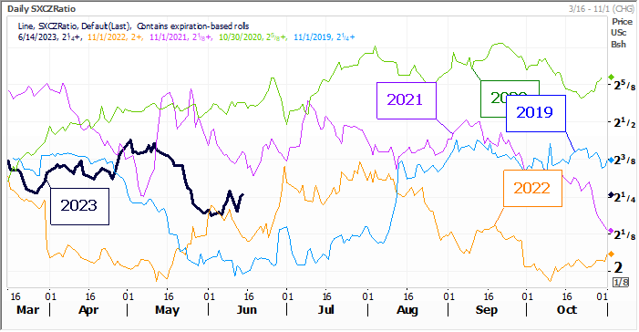
SX/CZ
WEATHER
TO WATCH
-
Alberta
and portions of Saskatchewan, Canada will receive waves of rain during the next ten days improving soil moisture in some of the driest areas and revitalizing some of the withering wheat, barley, canola and other crops produced in the region -
Far
southeastern Alberta and far southwestern and southeastern Saskatchewan may not get much rain, although a few showers are expected -
Not
much rain will fall from eastern Minnesota, eastern Iowa and western Wisconsin through the heart of Illinois to southern Indiana and a part of northern Kentucky in this coming week to ten days -
These
areas are already too dry and crop moisture stress will be intensify -
Yield
loss potentials are rising in this region -
Eastern
U.S. Midwest crop areas will get additional rain today and Thursday with Ohio and Pennsylvania wettest relative to normal
-
Net
drying is expected for a while thereafter until sometime next week when showers may return again -
U.S.
Delta and southeastern states will experience waves of rain with some excessive amounts possibly resulting in some flooding during the next ten days -
Areas
from the heart of the Delta into Georgia are most favored for the greatest rainfall -
U.S.
central Plains summer crop areas will experience a good mix of weather during the next ten days -
Some
winter wheat areas may be a little wetter than desired, but the impact should be relatively low due beneficial breaks in the weather with greater sunshine and drying conditions expected at times
-
Northern
U.S. Plains, the Upper U.S. Midwest and southeastern Canada Prairies will experience restricted rainfall for a while, although totally dry weather is unlikely -
There
will be a growing need for greater volumes of rain in parts of this region which are already quite dry -
Washington’s
Yakima Valley and neighboring areas of north-central Oregon will be dry for much of the next ten days leaving a big need for rain in unirrigated crop areas -
Showers
in the Snake River Valley of Idaho and in much of Montana and Wyoming will be good for sugarbeets, dry beans and other crops produced in the region during the next ten days -
Much
of western and southern Texas will be dry biased for the next ten days and possibly longer with temperatures rising above normal -
Extreme
highs in the 90s to over 100 Fahrenheit are expected frequently -
Crop
and livestock stress is expected -
U.S.
temperatures will be cool in the Midwest for a while into the end of this week and then warmer this weekend into early next week before some additional cooling occurs later next week -
The
mix of temperatures will help keep moisture stress low in the driest areas -
Northern
Europe dryness will continue most serious from northeastern France through Germany to a part of western Poland and northward to Belgium, Netherlands and Denmark through the weekend
-
Relief
from dryness is expected to evolve gradually next week -
Sufficient
rain is expected by July 1 to improve topsoil and crop conditions -
Drying
will also occur in Russia, the Baltic States, eastern Belarus and eastern Ukraine during much of the next ten days firming the soil and raising the need for rain -
A
larger part of Ukraine and Belarus will be impacted by dryness into early next week before rain begins -
Eastern
Russia’s New Lands and northern Kazakhstan will remain drier than usual through the next ten days, although milder than usual temperatures will help limit crop stress for a while -
Southern
Europe will continue wetter than usual for much of the coming ten days limiting fieldwork and slowing some crop development for a while -
North
Africa’s rainy weather pattern of the past few weeks will end after today’s rain ends -
West-central
Africa rainfall has been and will continue to be quite abundant during the next ten days favoring coffee, cocoa, sugarcane and rice development -
A
few areas have been trending a little too wet and less rain might be welcome -
Cotton
areas in Burkina Faso and Mali are trending much wetter -
East-central
Africa rainfall continues to occur routinely and mostly supports normal rice, coffee, cocoa and sugarcane development -
China’s
northern Yellow River Basin and neighboring areas of Inner Mongolia are trending drier and this pattern will prevail for a while possibly leading to crop moisture stress for wheat, coarse grains and oilseeds later this summer -
Southern
China will remain plenty wet and may become excessively wet soon -
This
will interfere with early rice maturation and harvesting with some crop quality declines possible -
Some
sugarcane areas will eventually be flooded -
Most
of the greatest rain will be south of rapeseed areas; though much of the rapeseed harvest has likely been completed -
Xinjiang,
China will experience seasonable temperatures over the next two weeks -
The
province has struggled with coolness in recent weeks and crop development is behind the usual pace -
Production
potentials have decreased because of some reduced area planted and due to the poor early season start to crop development -
There
is concern over early season frost and freeze potentials coming along before the crop is fully mature
-
Crop
conditions are improving because of the recent development of more seasonable temperatures -
Recent
high temperatures have been in the 90s to slightly over 100 Fahrenheit -
Tropical
Cyclone Biparjoy was 169 miles southwest of the northwestern most coast of Gujarat, India at 1200 GMT today moving northeast and producing sustained wind speeds of 100 mph -
Landfall
is expected around 1700 GMT Thursday in far northwestern Gujarat with wind speeds of 80 mph, a notable storm surge and torrential rainfall likely
-
Rainfall
should vary from 6.00 to 12.00 inches in general with local totals to more than 15.00 inches
-
Remnants
of the tropical cyclone will move through southern Rajasthan to north-central Madhya Pradesh, India Friday into the Sunday with a swath of heavy rain likely to accompany it -
Portions
of southeastern Sindh, Pakistan will also be adversely impacted by the storm -
India’s
monsoon continues having trouble getting started, but once Tropical Cyclone Biparjoy moves inland and dissipates Thursday through Sunday the potential for greater rain in India will begin rising -
June
20-26 should be much wetter for many areas in India, but not in the west-central parts of the nation where it is likely to remain drier than usual -
Western
Thailand, western Cambodia and Vietnam rainfall continues lighter than usual with little change likely for the next ten days -
Rain
is falling in some of these areas, but not enough has occurred to bolster subsoil moisture and water supply along with rivers and streams are still running low -
Australia
soil moisture is still mostly good for wheat, barley and canola emergence and establishment -
Weather
in the coming ten days will remain plenty wet in crop areas near the southern coast -
A
boost in rainfall will be needed in interior Western Australia (especially in northern crop areas) and in Queensland as well as a few interior South Australia locations -
South
Africa’s southwestern wheat and barley production region continues to get rain with more expected -
Winter
crops in the region are well established -
Some
increase in rain would be welcome for winter crops in Free State -
Argentina
dryness remains a concern for Cordoba, western Buenos Aires and La Pampa while crop areas to the east have seen sufficient rain for aggressive planting and good early season emergence and establishment -
Rain
prospects are poor in Argentina for the next ten days -
Above
normal rain is expected from Mato Grosso to northern Rio Grande do Sul, Santa Catarina, Parana and Sao Paulo, Brazil during the coming week slowing fieldwork and inducing soggy field conditions in wheat and corn areas -
There
is no risk of crop damaging cold in the next ten days -
Drier
weather is needed to protect crop conditions -
Minas
Gerais, Espirito Santo and Rio de Janeiro crop areas of Brazil will be wetter than usual for a brief period of time Friday through Sunday
-
Delays
in sugarcane, coffee and citrus harvesting is expected, but improved weather should evolve next week to limit any concerns.
-
Mexico
drought will continue for at least the next ten days with monsoonal precipitation staying quite limited
-
Delays
in summer crop planting are occurring and concern over sugarcane, coffee, citrus and rice is rising -
Sorghum,
cotton and corn may not perform well for a while with some planting of corn and sorghum to be delayed until seasonal rains arrive -
Central
America rainfall is expected to be abundant to excessive during the next ten days possibly leading to some areas of flooding -
Indonesia,
Malaysia and Philippines rainfall will be mostly well timed for a while, although there will continue to be pockets of drying in Indonesia and Malaysia.
-
Today’s
Southern Oscillation Index was -13.37 and it will move erratically higher over the next several days
Source:
World Weather, INC.
Wednesday,
June 14:
- FranceAgriMer
monthly grains balance sheet - New
Zealand food prices - EIA
weekly US ethanol inventories, production, 10:30am
Thursday,
June 15:
- USDA
weekly net-export sales for corn, soybeans, wheat, cotton, pork and beef, 8:30am - Port
of Rouen data on French grain exports
Friday,
June 16:
- ICE
Futures Europe weekly commitments of traders report - CFTC
commitments of traders weekly report on positions for various US futures and options, 3:30pm - FranceAgriMer’s
weekly crop condition report
Fed
Set To Pause And Keep Option To Raise Rates In July; ECB Expected To Hike Another Quarter Point As Tightening Cycle Nears Terminus
ECB
Expected To Hike Another Quarter Point As Tightening Cycle Nears Terminus
US
PPI Final Demand (M/M) May: -0.3% (est -0.1%; prev 0.2%)
US
PPI Ex Food And Energy (M/M) May: 0.2% (est 0.2%; prev 0.2%)
US
PPI Final Demand (Y/Y) May: 1.1% (est 1.5%; prev 2.3%)
US
PPI Ex Food And Energy (Y/Y) May: 2.8% (est 2.9%; prev 3.2%)
US
DoE Crude Oil Inventories (W/W) 9-June: 7919K (exp -1536K; prev -452K)
Distillate:
2123K (exp 1750K; prev 5074K)
Cushing:
1554K (prev 1721K)
Gasoline:
2108K (exp 1000K; prev 2745K)
Refinery
Utilisation: -2.10% (exp 0.00%; prev 2.70%)
·
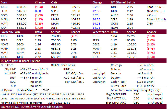
Unusual trading day. Corn futures for the majority of the session traded lower from a slight correction in CBOT agriculture markets and lack of fresh news. September ended up unchanged after a late recovery.
·
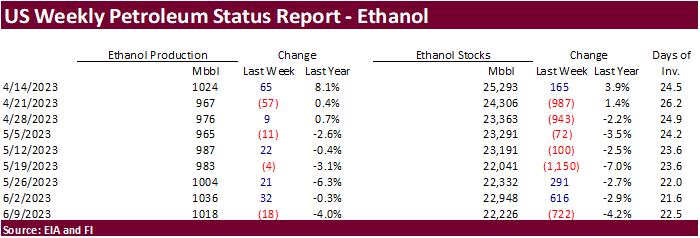
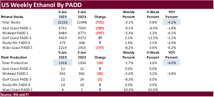
US ethanol production fell from the previous reporting week and that renewed ideas of demand destruction as US cash prices remain high and exports have slowed.
·
US weather outlook hasn’t changed that much so losses could be limited for the duration of the week. Note Monday is a US holiday. Look for positioning Thursday and Friday.
·
Russia said they have not decided whether or not to extend or adjust fertilizer export duties. Russia is a crucial global provider of fertilizer.
·
USDA Broiler Report showed broiler eggs set in the US up one percent and chicks placed down 1 percent. Cumulative placements were down slightly from the same period a year earlier.
·
USDA turkey hatchery:
-
Eggs
in Incubators on June 1 Up 7 Percent from Last Year -
Poults
Hatched During May Up 4 Percent from Last Year -
Net
Poults Placed During May Up 4 Percent from Last Year
Weekly
US ethanol production
was down 18,000 barrels to 1.018 million and stocks fell a large 722,000 barrels to 22.226 million. For comparison, a Bloomberg poll looked for weekly US ethanol production to be up 7,000 thousand barrels and stocks up 104,000 barrels to 23.052 million. Sep
to date ethanol production is down 3.1% from the same period for 2021-22. US gasoline stocks increased by 2.1 million barrels to 220.9 million and implied demand for gasoline dropped 25,000 barrels to 9.193 million, about up 1.8 percent over a 4-week period
compared to year ago. Ethanol blended into finished motor gasoline ran at about 91.3 percent of the total, a four-week high.
US
DoE Crude Oil Inventories (W/W) 9-June: 7919K (exp -1536K; prev -452K)
Distillate:
2123K (exp 1750K; prev 5074K)
Cushing:
1554K (prev 1721K)
Gasoline:
2108K (exp 1000K; prev 2745K)
Refinery
Utilisation: -2.10% (exp 0.00%; prev 2.70%)
University
of Illinois: Nitrogen Fertilizer Prices Stabilize at High Levels in Spring 2023
Schnitkey,
G., N. Paulson, C. Zulauf and J. Baltz. “Nitrogen Fertilizer Prices Stabilize at High Levels in Spring 2023.”
farmdoc daily (13):108, Department of Agricultural and Consumer Economics, University of Illinois at Urbana-Champaign, June 13, 2023.
Export
developments.
-
Results
awaited: Iran seeks 120,000 tons of soybean meal and 120,000 tons of corn.
July
corn $5.75-$6.35
September
corn $4.50-$5.75
December
corn $4.25-$5.75
·
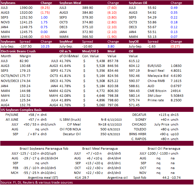
CBOT soybeans were lower to start following light weakness in products and risk off trading after trading in a higher but very choppy session on Tuesday. Then soybeans rebounded, exception July and August, after soybean oil caught
a bid. Yesterday August soybeans nearly tested its 50-day MA of $13.3775. May 2024 fell 0.50 cent. The mixed close indicates lack of direction.
·
Higher Malaysian and China palm oil and near unchanged EU cash vegetable oil prices did limit downside movement in CBOT soybean oil earlier and the August soybean oil contract hit buy stops after trading through its 100 day moving
average (55.07 that readjusts after today’s close). Dry weather for the EU and US coupled with EPA’s decision to delay RVO mandates also limited earlier losses for SBO.
·
NOPA US crush is due out Thursday and traders are looking for 175.88 million bushels for the month of May, down on a daily adjusted basis from April but up nearly 3 percent from year ago. Soybean oil stocks are expected to drop
to 1.942 billion pounds from 1.957 billion pounds at the end of April (a 14 month high).
·
August Malaysia palm futures traded 36 ringgit higher to 3452.
·
Argentina Rosario grains exchange: 2022-23 soybean production 20.5 MMT versus 21.5MMT previous.
Export
Developments
-
Egypt
bought 18,000 tons of vegetable oils consisting of 6,000 sunflower oil at $926 per ton c&f and 12,000 soybean oil at $1,048/ton for arrival between August 20 and September 15.
They
were also in for a small amount of local vegetable oils, but no results were reported.
-
Iran
seeks 120,000 tons of soybean meal and 120,000 tons of corn on June 14. -
Algeria
passed on soybean meal. -
USDA
last week bought 1,220 tons of vegetable oils for export at $1,947-$2,292 per ton.
-
USDA
seeks 6,410 tons of vegetable oils on June 15 for FH July shipment to the Dominican Republic.
-
USDA
seeks 77,000 tons of soybean meal on June 14 for July 10-31 shipment to Indonesia.

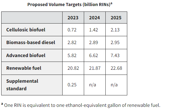
EPA
December 2022
Soybeans
– July $13.70-$14.30, November $11.00-$14.50
Soybean
meal – July $370-$415, December $290-$450
Soybean
oil – July 54.00-57.00, December 49-57
·
By session end, most US wheat futures traded lower today on light profit taking by funds bias Chicago & KC, and follow through selling for higher protein wheat from rain prospects for the central and northern Great Pains this
week. MN saw limited losses, a surprise with rain in the forecast for parts of Canada’s major producing areas.
·
September Paris milling wheat officially closed 5.75 euros lower, or 2.4%, at 233.25 euros a ton (about $253.25 ton).
·
FranceAgriMer lowered French soft wheat exports outside the European Union for 2022-23 by 100,000 tons to 10.2 million toes, 16% above the previous season.
·
Hot weather is expected to dominate mainland EU this month.
·
Egypt bought 3.5 million tons of local wheat since mid-April, about 350,000 tons greater than what they secured as of around June 10. They will need to import about 5 million tons to reach their 8.25 million ton subsidy program
for the 2023-24 crop year.
·
Look for Egypt to float another import tender soon as the latest purchase of one Russian wheat cargo was thought to be in jeopardy over payment issues.
·
Argentina Rosario grains exchange: Planted area of wheat 5.6 million hectares.
·
Argentina will see net drying over the next week, unwelcome for the recently planted wheat crop.
·
Russia’s Deputy Prime Minister Viktoria Abramchenko noted 2023 Russian wheat exports could grow 10 percent from 2022, which saw a 12 percent growth in terms of revenue (41.5 USD billion).
·
Agritel: Romania wheat production downward revised 15% to 8.76 MMT from 10.35 MMT projected last April, compared to 9.2 MMT year ago.
·
Kyiv School of Economics put out a study suggesting Ukraine’s food production could take 20 years or more to recover.
Export
Developments.
·
Taiwan bought 56,000 tons of US wheat from the US for July 31-August 14 shipment off the PNW. That included U.S. dark northern spring wheat 14.5% protein content at an estimated $341.35 a ton FOB U.S. Pacific Northwest coast or
$368.30 c&f. Another hard red winter wheat 12.5% protein content at $316.32 a ton FOB/$343.27 c&f per ton and soft white wheat 8.5%/max 10% protein at $278.01 a ton FOB/$304.96 a metric ton c&f. (Reuters)
·
Results awaited: Morocco seeks 500,000 tons of feed barley on June 14.
·
Japan in a SBS import tender seeks 60,000 tons of feed wheat and 20,000 tons of barley on June 19 for arrival by November 30.
Rice/Other
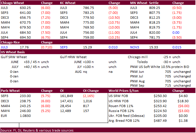
Chicago
Wheat July $6.00-$6.50, September $5.50-$6.75
KC – July $7.60-$8.50, September $7.50-$9.00
MN –
July $7.80-$8.50, September $7.25-$9.00
#non-promo
