PDF Attached
FI crop progress tables will be related Tuesday as I am out of the office.
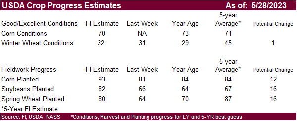
US corn planting 92% (exp 92%) 84% 5yr avg
US corn 69% G/E (exp 71%) 73% yr ago
US soybean planting 83% (exp 82%) 65% 5yr avg
US spring wheat planting 85% (exp 82%) 86% 5yr avg
US winter wheat 34% G/E (exp 32% G/E) 29% yr ago
Calls:
Corn unchanged to 2c higher
Wheat down 1-4c
KC/Minn unchanged to down 3c
Soybeans unchanged to down 3c
Liquidations
was noted across the board on the improved weather outlook adding more rain and the “hot and dry” talk pushed to the last half of June. We are still early in the crop cycle to get the market to have a sustained rally on weather. US HRW wheat areas saw rain
over the weekend, but drought conditions are not expected to improve much.
Weather
Last
seven days
Next
seven days
WEATHER
TO WATCH
-
The
heart of the U.S. Midwest will be dry and warm biased into early next week -
Rain
is expected late next week and into the following weekend with some cooling as well -
The
event will be very important in determining the longer range outlook for the region – if rainfall is limited there may be reason for more market worry -
World
Weather, Inc. is still expecting cool weather in late June over the Midwest and if that occurs after the short term break from dry and warm weather next week there may not be much reason for huge market excitement -
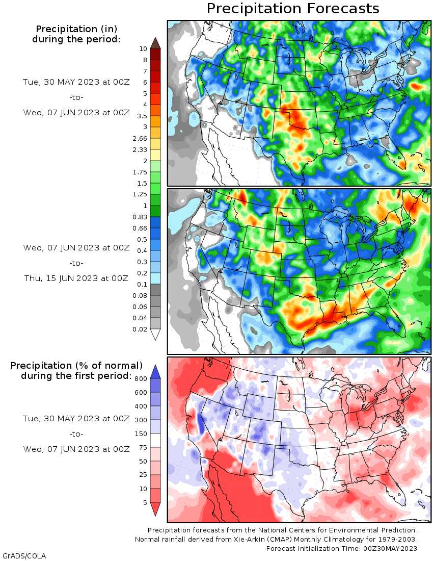
Rainfall
next week will be very important – early indications suggest it will be timely, but still lighter than usual offering some short term relief from drying, but more rain will be needed -
Abundant
moisture falling in the U.S. Plains and periodic rain in Canada’s central Prairies will leave the potential for a strong ridge of high pressure to develop rather low for a while -
Sufficient
moisture is going into the ground to provide feedback moisture keeping any ridge building weak for a while -
West
Texas rainfall has become frequent and significant enough to restrict planting progress in some grain and cotton production areas -
Drier
weather is needed -
Some
dryland production areas of West Texas still need greater rain -
Additional
showers and thunderstorms over the next ten days will maintain a wetter biased environment, although the dryland areas of the southwest will have need for more moisture -
Latest
Pacific Ocean surface water temperature data shows more weakening in the negative PDO -
Notable
warming has been occurring in the past couple of weeks off the west coast of North America while cooling is occurring south of the Aleutian Islands -
Both
suggest a steady reduction in the intensity of negative PDO, although the event is still significant enough to impact North America weather for several more weeks -
Today’s
Southern Oscillation Index was -14.79 and it should move erratically this week -
El
Nino continues to evolve -
Latest
ocean temperature data shows a slower progress of warming, but the trend is still in place and an El Nino event is likely to be declared in place next month -
Please
be sure to recall that El Nino’s influence will first be on the tropics and it will take a few weeks or months for a mid-latitude influence to begin -
U.S.
Midwest rainfall is expected to be limited over the coming week, although a few showers will pop up periodically -
A
cool front expected next week will bring some cooling and a little increase in rainfall coverage and amounts, but the Gulf of Mexico is still not open as a good moisture source for the Midwest or Delta this week -
Temperatures
will be warm, but not excessively hot -
Rainfall
this week (ending Sunday) will be too light to counter evaporation in the central and eastern Midwest while 0.20 to 0.75 inch occurs in the western Corn Belt with a few amounts of 0.75 to 1.50 inches
-
Portions
of Nebraska to Minnesota and eastern North Dakota will be wettest -
U.S.
Delta and southeastern states will experience restricted rainfall through the next ten days
-
U.S.
Great Plains precipitation will occur relatively often through the next ten days as atmospheric instability remains setting off isolated to scattered showers and thunderstorms relatively often through mid-week next week -
Rain
totals of 0.30 to 1.00 inch and local totals of 1.00 to 2.00 inches are expected with some potential for locally more -
Amounts
will vary greatly, though Montana and areas from Nebraska into western Texas will be wettest
-
Washington,
Oregon and California rainfall will be restricted during the next ten days while showers in Idaho Wyoming and neighboring areas benefits dry bean and sugarbeet development -
U.S.
weather Friday through Monday included dry and seasonably warm temperatures across the Midwest and a majority of the Delta -
Rain
and very cool temperatures occurred in the Carolinas, eastern Kentucky and Virginia where highs were limited to the 50s and 60s early in the weekend before warming to the lower 70s Sunday and a little warmer Monday
-
Rainfall
of 1.00 to nearly 3.00 inches resulted across the Carolinas and eastern Georgia while up to 0.50 inch occurred in central and eastern Virginia -
The
remainder of the southeastern states were dry -
Jackson,
TN reported 1.41 inches of rain from a lone thunderstorm complex that occurred Saturday evening; otherwise the Delta received very little rain and experienced net drying -
A
very intense thunderstorms complex that was slow to move or to dissipate occurred at McCook Nebraska where more than six inches of rain fell, but that was an anomaly and not representative of weather in the region during the weekend -
Thunderstorms
occurred across much of West Texas and the Texas Panhandle as well as neighboring areas during the weekend with rainfall of 0.50 to 2.00 inches resulting -
The
greatest rain fell near and east of a line from Lubbock to Plainview, Texas where several countries received at least some rain of 1.00 to more than 2.00 inches of rain -
Rainfall
in the western High Plains of West Texas varied from 0.25 to 0.75 inch with local totals to 1.50 inches
-
Kansas
rainfall was restricted once again with very little moisture occurring in the driest areas of the state -
Rain
was widespread from northeastern Colorado and north-central and northwestern Kansas through western Nebraska to Montana and the western Dakotas with 0.30 to 1.00 inch of rain common and local totals of 1.00 to 2.00 inches
-
Limited
rainfall occurred from the U.S. Pacific Northwest through California to the southwestern desert areas
-
Canada’s
Prairies will get scattered showers and thunderstorms this week, but Alberta’s drought region is not likely to be impacted by much rain leaving the region quite dry -
Rainfall
outside of east-central and southern Alberta will be erratic and light until late this week and during the weekend when a boost in rain is expected in Saskatchewan and parts of Manitoba -
Another
cool front pushing through the eastern Prairies next week will stimulate a few more showers and thunderstorms -
Ontario
and Quebec, Canada wheat, corn and soybean areas will experience much warmer temperatures and limited rainfall over the next ten days -
The
change will be welcome for a while after a cool and sometimes wet spring -
Some
timely rain and cooling will be needed and should occur late next week -
Europe
weather will continue drier than usual in the north and Baltic Sea regions for another ten days raising concern over crop and field conditions, although not much heat is expected -
Northern
Europe has been drier than usual for an extended period already and the ground is beginning to firm up – rain will be needed soon -
Southern
Europe is plenty wet and will likely remain that way for a while -
Spain
continues to receive frequent rain along with southern France, Italy and the western Balkan Countries -
North
Africa received rain Friday through Monday and more will fall periodically through the next week to ten days -
The
rain comes late in the growing season and may be threatening durum wheat quality in Morocco and northwestern Algeria while crop areas to the east may have benefited from recent rain.
-
Russia’s
New Lands continued to dry down during the weekend with limited rainfall and high temperatures in the 80s Fahrenheit -
Slowly
increasing potentials for rain are expected in this coming ten days, though the rain distribution will not be even leaving areas of needed rain -
China
reported excessive rain between the Yellow and Yangtze Rivers during the weekend
-
Several
locations in the Yangtze River Basin reported 15.00 to more than 22.00 inches of rain during the past four days -
Much
of the rain reported in east-central China varied from 4.00 to 8.00 inches
-
Wettest
north of the Yangtze River through the Yellow River Valley -
Fieldwork
was delayed, but the moisture should prove to be good for summer crop development in areas that were not flooded -
Wheat
areas need to dry down to protect grain quality -
Xinjiang,
China temperatures continued cooler than usual during the weekend with highest readings in the 60s and 70s in the northeast and in the 70s and lower 80s in the west -
Lowest
morning temperatures were in the upper 40s and 50s in the northeast and the 50s in other areas -
Xinjiang,
China will continue cooler than usual -
Degree
day accumulations are well below normal and cotton, corn and other crops are not developing normally -
Warming
is needed -
The
next ten days will continue cooler than usual -
India
was wetter than usual during the weekend in northern parts of the nation -
The
moisture was good for a few early season crops; including cotton -
A
cooler than usual and wetter than usual bias will remain in northern India for the next ten days -
India’s
monsoonal precipitation will be well below normal during the first half of June in southern and eastern portions of the nation -
Thailand,
Cambodia and Laos rainfall in this coming week will be lighter than usual -
Some
beneficial rain fell during the weekend -
Typhoon
Mawar was located 238 miles northeast of Luzon Island, Philippines at 1400 GMT today and 352 miles southeast of Taipei, Taiwan
-
Peak
wind speeds were reaching 103 mph and gusting to 127 mph -
The
storm was expected to turn to the northeast this week resulting in the storm’s passage across the Ryukyu Islands of Japan during mid- to late-week while continuing to weaken -
Mawar
should weaken sufficiently to have a low impact on the minor islands of Japan outside of heavy rain, moderately strong wind speeds and rough seas -
Taiwan
and Luzon Island, Philippines are not likely to be impacted by the storm -
Australia
rainfall during the weekend was greatest in Victoria, southeastern South Australia and southern New South Wales benefiting topsoil moisture and better winter crop establishment -
Australia
weather during the next ten days should be unsettled enough to produce rain in some of the more important winter crop areas to help get winter crops better established -
Resulting
rainfall will be light, though, leaving need for much more away from the coast
-
South
Africa rainfall in this coming week will be sufficient to support good wheat, barley and canola emergence and establishment -
Some
summer crop harvest delays are likely and some interruption to late season winter crop planting is also expected -
The
moisture will help winter crops become better established -
Argentina
rainfall will be restricted in this next ten days, but last week’s rain has soil moisture looking very good for planting from Santa Fe and Entre Rios into central and eastern Buenos Aires -
Western
Buenos Aires and Cordoba still have a big need for rain and they may have to wait for a while -
Brazil
weekend rain in Mato Grosso do Sul, Parana and immediate neighboring areas was good for Safrinha crops – especially those planted so very late -
The
moisture was also good for wheat establishment -
Additional
mid-week rain is expected from Mato Grosso to Sao Paulo and Parana bolstering soil moisture for assurance that late planted crops will finish without a serious moisture shortage threatening production -
Brazil
sugarcane, citrus and coffee harvest delays are expected briefly this week due to rain, but drier weather will be quick enough to resume to prevent any negative impact -
Central
America rainfall is expected frequently over the next ten days supporting improved soil moisture and some better runoff after a slow start to the rainy season -
Mexico
rainfall will be confined to the far east and extreme south this week while other areas are dry biased -
The
rain will be welcome, but greater amounts will soon be needed in the central and western parts of the nation -
Indonesia
and Malaysia rain frequency and intensity has been and is expected to continue better than advertised last week -
The
pattern will perpetuate favorable crop conditions from rice and sugarcane to oil palm, coconut and rubber development -
Philippines
rainfall will remain well mixed with sunshine over the next ten days -
West-central
Africa will continue to receive periodic rainfall over the next two weeks and that will prove favorable for main season coffee, cocoa and sugarcane -
Some
cotton areas would benefit from greater rain, though the precipitation that has occurred has been welcome -
East-central
Africa rainfall has been favorable for coffee, cocoa and other crops in recent weeks with little change likely -
Central
Asia cotton and other crop weather has been relatively good this year with adequate irrigation water and some timely rainfall reported -
The
favorable environment will continue
Source:
World Weather, INC.
Tuesday,
May 30:
- USDA
export inspections – corn, soybeans, wheat, 11am - US
planting data for corn, cotton, spring wheat and soybeans, 4pm - US
cotton and winter wheat condition, 4pm - EU
weekly grain, oilseed import and export data - EARNINGS:
FGV
Wednesday,
May 31:
- US
agricultural prices paid, received - Malaysia’s
May palm oil exports
Thursday,
June 1:
- EIA
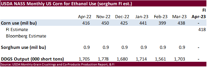
weekly US ethanol inventories, production, 11am - USDA
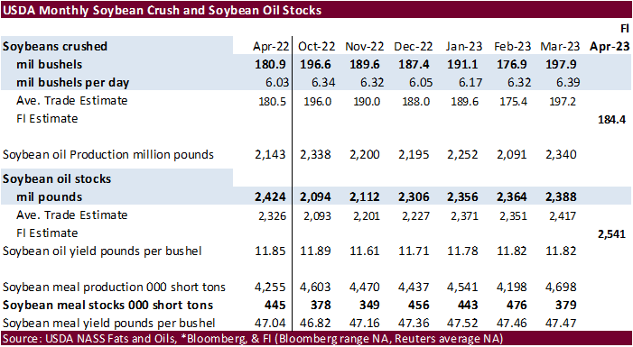
soybean crush, corn for ethanol, DDGS production, 3pm - Port
of Rouen data on French grain exports - HOLIDAY:
Indonesia
Friday,
June 2:
- FAO
food price index, monthly grains report - USDA
weekly net- export sales for corn, soybeans, wheat, cotton, pork and beef, 8:30am - ICE
Futures Europe weekly commitments of traders report - CFTC
commitments of traders weekly report on positions for various US futures and options, 3:30pm - FranceAgriMer’s
weekly crop condition report - HOLIDAY:
Italy, Indonesia
Source:
Bloomberg and FI
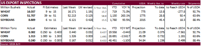
USDA
inspections versus Reuters trade range
Wheat
382,031 versus 200000-600000 range
Corn
1,313,411 versus 600000-1400000 range
Soybeans
239,736 versus 100000-400000 range
GRAINS
INSPECTED AND/OR WEIGHED FOR EXPORT
REPORTED IN WEEK ENDING MAY 25, 2023
— METRIC TONS —
————————————————————————-
CURRENT PREVIOUS
———–
WEEK ENDING ———- MARKET YEAR MARKET YEAR
GRAIN 05/25/2023 05/18/2023 05/26/2022 TO DATE TO DATE
BARLEY
0 0 73 2,154 10,229
CORN
1,313,411 1,326,281 1,412,248 28,691,303 42,308,082
FLAXSEED
0 0 0 200 324
MIXED
0 0 0 0 0
OATS
0 0 0 6,686 600
RYE
0 0 0 0 0
SORGHUM
33,169 116,048 144,690 1,669,067 6,120,819
SOYBEANS
239,736 166,590 404,350 48,450,848 49,550,493
SUNFLOWER
0 0 0 2,508 2,260
WHEAT
382,031 440,094 344,319 19,557,889 19,997,455
Total
1,968,347 2,049,013 2,305,680 98,380,655 117,990,262
————————————————————————-
CROP
MARKETING YEARS BEGIN JUNE 1 FOR WHEAT, RYE, OATS, BARLEY AND
FLAXSEED;
SEPTEMBER 1 FOR CORN, SORGHUM, SOYBEANS AND SUNFLOWER SEEDS.
INCLUDES
WATERWAY SHIPMENTS TO CANADA.
Macros
Fed
Funds Futures Now Pricing In A 63% Chance Of A Fed Hike In June – Fedwatch
US
FHFA House Price Index (M/M) Mar: 0.6% (est 0.2%; prevR 0.7%)
US
House Price Purchase Index (Q/Q) Q1: 0.5% (prevR 0.2%)
US
S&P CoreLogic CS 20-City (M/M) SA Mar: 0.45% (est 0.00%; prevR -0.07%)
US
S&P CoreLogic CS 20-City (Y/Y) NSA Mar: -1.15% (est -1.70%; prev 0.36%)
US
S&P CoreLogic CS US HPI (Y/Y) NSA Mar: 0.66% (prevR 2.13%)
Canadian
Current Account Balance (CAD) Q1: -6.17B (est -9.50B; prevR -8.05B)
US
Conf. Board Consumer Confidence May: 102.3 (exp 99.0; prevR 103.7)
Conf.
Board Present Situation May: 148.6 (prevR 151.8)
Conf.
Board Expectations May 71.5 (prevR 71.7)
Corn
·
Corn ended lower on a slightly wetter forecast for the first week of June. Hot and dry talk is still in the market for the last half of June, but we are still many weather runs away from that so the market is keeping an eye on
it.
·
Demand worries and month-end selling was also noted. With a debt ceiling deal likely to get done we may see some safe haven commodity risk shift back into equity and interest-rate markets.
·
USDA initial corn conditions came in at 69% G/E which was below the 71% expected. Most of the miss can be attributed to the low initial rating in PA, MO, and NE. Last year we were at 73% G/E and the 5-year average of 71 percent.
Export
developments.
-
None
reported
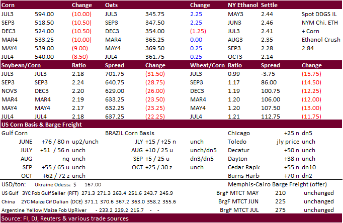
July
corn $5.25-$6.25
September
corn $4.25-$5.50
December
corn $4.25-$5.75
·
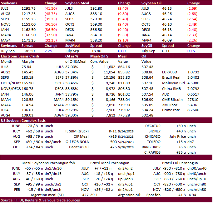
Soybeans finished lower on improving weather, and risk-off and month-end selling as in all ag markets.
·
Soymeal closed down 2.3% while Bean oil fell 5.5%. Crude oil was down 4.3%
·
USDA crop progress showed that 83% of the crop was planted compared to the 65% 5yr average. Next week will get the first look at soybeans crop rating.
·
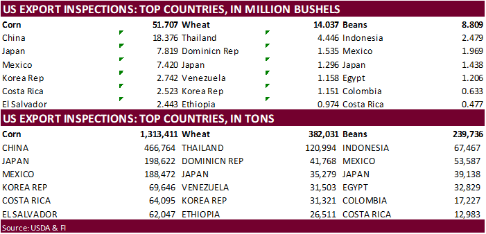
USDA US soybean export inspections as of May 25, 2023 were 239,736 tons, within a range of trade expectations, above 166,590 tons previous week and compares to 404,350 tons year ago. Major countries included Indonesia for 67,467
tons, Mexico for 53,587 tons, and Japan for 39,138 tons.
Export
Developments
·
Egypt seeks vegetable oils June 1 for July 11-25 arrival.
·
USDA seeks 1,140 tons of packaged vegetable oil on June 6 for July shipment.
Soybeans
– July $12.75-$14.00, November $11.00-$14.50
Soybean
meal – July $370-$450, December $290-$450
Soybean
oil – July 44-50, December 43-53, with bias to upside
Wheat
·
Wheat closed lower on demand worries and risk-off selling. Also, wheat futures are lower from improving US HRW wheat weather, ample India wheat supplies, and improving Russian grain summer production prospects.
·
Most traders were ignoring Black Sea headlines. This could become a supportive feature later this week after the funds settle down after month-end.
·
US SRW wheat futures fell below nearby corn futures. This has happened a few times since 2021, but in general rare to see. Also explains expectations for a larger SRW yield relative to USDA’s May projection.
·
The Ukraine/Russia conflict should be monitored as it continues to intensify. Russia and Ukraine traded drone attacks in Kyiv and Moscow.
·
September Paris wheat futures were down 5.75 euros to 220.25 per ton.
·
USDA US all-wheat export inspections as of May 25, 2023 were 382,031 tons, within a range of trade expectations, below 440,094 tons previous week and compares to 344,319 tons year ago. Major countries included Thailand for 120,994
tons, Dominican Rep for 41,768 tons, and Japan for 35,279 tons.
University
of Illinois: An Estimate of Winter Wheat Production
Ibendahl,
G. “An Estimate of Winter Wheat Production.” farmdoc daily (13):97, Department of Agricultural and Consumer Economics, University of Illinois at Urbana-Champaign, May 26, 2023.
https://farmdocdaily.illinois.edu/2023/05/an-estimate-of-winter-wheat-production.html
Export
Developments.
Rice/Other
·
Look for US rice and cotton conditions to improve this week.
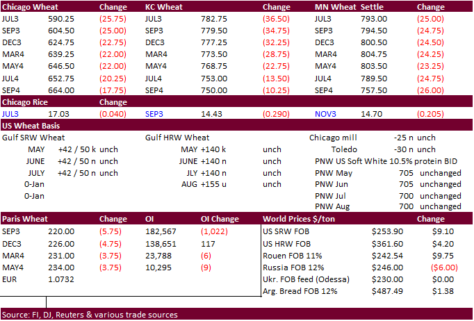
Chicago Wheat – July $5.50-$6.50
KC – July $7.50-$8.75
MN – July $7.25-$8.75
September – same ranges as July
#non-promo