Soybeans
5-10 higher
Corn
4-8 higher
Chicago,
KC and MN wheat 5-10 higher (MN could be more than 10 post open)
Initial
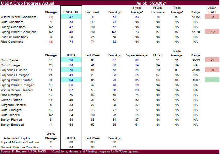
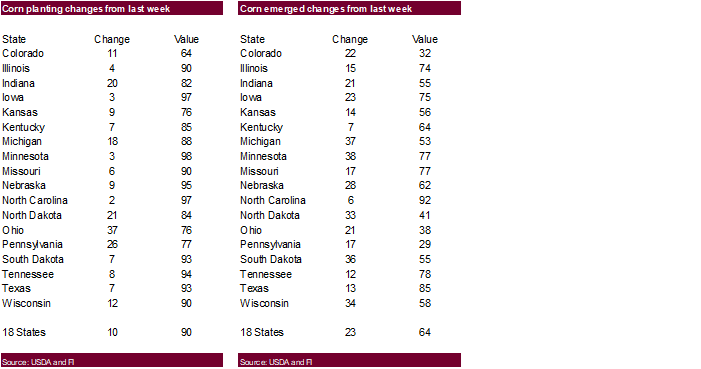
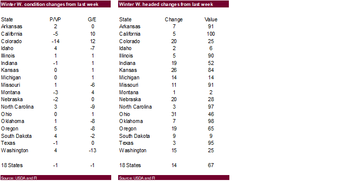
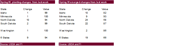
spring wheat conditions came in 12 points below expectations at only 45 percent G/E. Winter wheat declined 1 point and was 3 points below expectations. Corn plantings at 90 percent were one point above expectations but ten above average. Soybean plantings
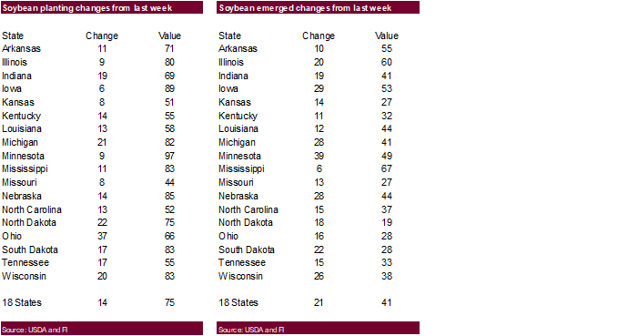
of 75 percent
Favorable
weather for many parts of the world dragged CBOT agriculture futures lower. Many countries were on holiday and volume was on the light side. News was very thin. Egypt bought 240,000 tons of wheat. The US 6–10-day precipitation outlook calls for rain to
fall across the ECB, which is welcome. Brazil
is finally seeing rain relief but for some of the corn it’s too late. Canada saw welcome rain relief over the past week, easing concerns for wheat and canola plantings. Rain will occur across the central and northern US Great Plains this week.


Next
7 days
 World
World
Weather, Inc.
Source:
World Weather, Inc.
World
Weather, Inc.
MOST
IMPORTANT WEATHER OF THE DAY
- Tropical
Cyclone Yaas was located 360 miles south southeast of Kolkata, India at 17.1 north, 89.9 east moving northerly at 7 mph and producing maximum sustained wind speeds of 40 mph
o
Yaas will intensify over the next two days as it moves closer to the upper India coast
- Peak
wind speeds will be near 100 mph when landfall occurs Tuesday night into Wednesday
o
Landfall is expected near the West Bengal/Odisha border
o
Torrential rain and flooding is expected
- Moisture
totals will vary from 6.00 to 12.00 inches with local totals to 15.00 inches and heavy rain will extend northward to Bihar and southeastern Uttar Pradesh during mid-week
o
Damage to rice and sugarcane is possible
- Brazil
rainfall during the weekend was widespread from Rio Grande do Sul northward through Parana to western Sao Paulo and then northwest from there to southern Goias and southeastern Mato Grosso; including much of eastern Mato Grosso do Sul
o
Amounts reached 4.20 inches in the far southeastern corner of Mato Grosso where some greater rain may have occurred from training thunderstorm activity
- Rainfall
elsewhere ranged from 0.35 to 1.50 inches with a few totals nearing 2.00 inches in Rio Grande Sul
o
The rainfall brought relief to persistent dry weather in Safrinha crop areas of Brazil
- Much
of the rain fell too late to seriously improve production, but some of the very latest crop might have benefited, although it was badly impacted by the past few weeks of rain and will still yield poorly - Sugarcane
and coffee maturation and harvesting were disrupted - Winter
wheat benefited most from the precipitation - Brazil
will trend a little drier today and Tuesday
o
A new weather disturbance will produce rain in the south during mid- to late week this week
- The
precipitation will end next weekend after another 0.40 to 1.50 inches of rain falls
- Rio
Grande do Sul will receive 2.00 to more than 5.00 inches of rain later this week
o
Temperatures will be cooler biased in the wettest areas
o
Next week’s weather will be much drier
o
Safrinha crop areas will not be as dry as they have been again through the next couple of weeks, despite drying next week
- Frost
and a couple of light freezes occurred this morning in south-central Parana and near the northeastern Parana/southern Sao Paulo border area where lows were 32 to 39 Fahrenheit
o
Some significant frost resulted, but no crop damage was suspected
o
Tuesday morning may have similar temperatures
- Brazil’s
southern crop areas will turn colder early next week and readings might reach into the frost range in parts of Parana wheat and corn country once again, but the majority of this week and weekend will trend warmer.
- Argentina
reported additional rain Friday after beginning Thursday
o
Additional amounts varied from 1.00 to 3.00 inches in central and northeastern Buenos Aires and 1.00 to 2.00 inches in southeastern Entre Rios and southern Uruguay
o
Amounts to 0.71 inch occurred elsewhere
o
Northwestern parts of the nation were dry
o
Recent rain delayed harvesting and wheat planting
- Argentina
will receive very little rain for the next ten days to two weeks
o
Crop moisture for wheat planting is mostly very good
o
Improved summer crop harvest progress is expected as this week moves forward
o
Temperatures will be a little cooler biased for a while this week and into next week especially in the east
- Tropical
disturbance off southern Vietnam coast failed to evolve more significantly during the weekend, but the system will produce 2.00 to 6.00 inches of rain in Vietnam’s Central Highlands and across portions of Cambodia and Thailand this week resulting in better
soil moisture and greater runoff
o
Rice, sugarcane and coffee will all benefit from the rain
- Tropical
Storm Ana dissipated Sunday evening after developing over open water in the western Atlantic Ocean early in the weekend
o
The storm had no significant impact on land
- Russia’s
southern New Lands and Kazakhstan will see a blocking high pressure center over the region break down this week allowing a few showers and thunderstorms to evolve and bring a little moisture to the region that has been quite dry and very warm in recent weeks
o
The break will be welcome, but resulting rainfall is not likely to be very great and there may continue to be need for significant rain, despite the lack of a high pressure ridge
o
The lower Volga River Basin will be wettest early this week
o
Other areas in southern parts of Russia’s New Lands and northern Kazakhstan rainfall is not likely to be significant until next week, although temperatures will cool down somewhat
- Western
Russia, Belarus and Baltic States will not be as wet as they have been in recent weeks, but drying will come slowly since some precipitation will continue and temperatures will be mild throughout this week - Less
intensive and less threatening rainfall is expected in southern China this week, although the region will continue to receive periodic rain and thunderstorms - North
China Plain will experience net drying conditions this week with temperatures a little warmer than usual
o
Subsoil moisture is still favorable west of Hebei and northeastern Shandong, but rain is going to be needed soon in Liaoning, Hebei and northeastern Shandong
- Northeastern
and far southern China will continue to see frequent bouts of rain intermixing with periods of sunshine during the next two weeks
o
Soil conditions in these areas will be wetter biased and some drier weather might be welcome
o
Temperatures in these wetter biased areas may be a little cooler than usual
- Weekend
precipitation in eastern China was greatest near and south of the Yangtze River where 2.75 to more than 6.00 inches resulted
o
Portions of northeastern Fujian reported up to 12.40 inches of rain
o
Much lighter rain fell from Gansu to northern Hebei with amounts to 0.80 inch common and local totals to 1.34 inches. Net drying occurred in most other areas
o
Temperatures were very warm to hot in the North China Plain and northeastern provinces with highest temperatures in the 80s and lower 90s Fahrenheit
- Xinjiang
China weather was dry biased during the weekend and temperatures were recovering from a very cold day Friday.
o
Frost and a light freeze occurred Saturday morning in the far northeast corner of Xinjiang, but low temperatures warmed to the 40s this morning
o
Lowest weekend temperatures elsewhere were in the 50s
o
Highest afternoon temperatures reached the 70s northeast and the 80s southwest
o
Most of Xinjiang’s key crop areas were dry
- Xinjiang
weather over the coming week will be a little warmer than that of last week especially in the northeast and precipitation will be limited
o
Daily high temperatures will be in the 70s and 80s northeast followed by lows in the 40s and 50s while highs in the southwest are in the 80s and lower 90s followed by lows in the 50s and lower 60s
- Eastern
Canada’s Prairies received additional rain and some snow Friday
o
Amounts reached 2.28 inches in southern Manitoba with other amounts of 0.30 to 1.77 inches in the south of Manitoba
- A
new storm began impacting Alberta and Saskatchewan Sunday and continues this morning
o
Moisture totals through 0100 CDT today varied from 0.05 to 0.88 inch with southern Alberta wettest so far
o
Friday’s rain and that which occurred earlier last week improved soil moisture in central Alberta, southern and eastern Saskatchewan and Manitoba
o
Dry conditions occurred from east-central Alberta through west-central and northwestern Saskatchewan, but rain will impact those areas this week
- Canada’s
Prairies will continue to be impacted by a second storm system through Tuesday from Alberta through Saskatchewan further improving soil moisture for wheat, barley, oats, canola, lentils, corn, soybean, flax and sunseed production areas
o
Not all areas will get significant relief, but every drop of rain will be precious and beneficial
- Southern
and east-central Alberta and some western and northern Saskatchewan locations will be wettest with 0.50 to 1.50 inches of moisture expected - Manitoba
will not get much moisture out of this new storm - Canada’s
Prairies will be drier biased again during the middle to latter part of this week
o
Next storm system is expected briefly Friday into Sunday with light amounts of rain resulting
o
Other opportunities for rain will evolve briefly next week
o
Temperatures will be cooler than usual this week and warmer next week
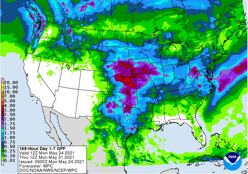
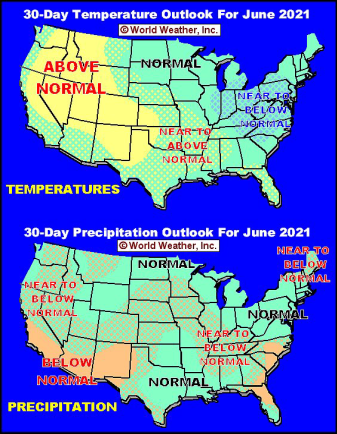
- Most
U.S. crop areas in the Great Plains, Midwest, Delta and southeastern states will get rain at one time or another over the two weeks maintaining a good environment for summer crop development
o
Temperatures will be cooler biased especially in the northern Plains and upper Midwest
o
Temperatures will be warmer than usual in the southeastern states this week while rainfall is lacking
o
Warm weather will also occur in the west-central and southwestern Plains into the southwestern desert region during the coming week
o
West Texas will get additional showers and thunderstorms periodically over the next week with sufficient rain falling to support more planting, germination and emergence
- Some
of the greatest rain in West Texas is expected tonight and early Tuesday with some follow up showers Tuesday night and again Thursday into Friday and again next week - U.S.
weekend weather was dry in the eastern Midwest, Delta and southeastern states and temperatures were very warm with highs in the 80s and some extremes near 90 degrees Fahrenheit
o
Not quite as warm from eastern Kansas and the northwest half of Missouri to eastern Iowa and western Illinois where 70s occurred Friday and Saturday
o
Temperatures were quite cool in the northwestern Plains where readings Friday and Saturday were in the 30s and 40s, but warmed to the 50s Sunday
o
Showers and thunderstorms occurred from the heart of Texas to Wisconsin and northwestern Illinois and from eastern Colorado to North Dakota
- Most
of the rain was light with a few strong thunderstorms in the high Plains where 1.00 to 3.00 inches of rain resulted from southwestern North Dakota into northeastern Colorado and southwestern Nebraska
o
Oregon’s dryland winter crop areas received 0.10 to 0.51 inch of moisture which helped ease dryness, but more rain is needed in the region
- Southeast
Canada corn, soybean and wheat production areas are experiencing good crop weather
o
Good planting progress is suspected and most wheat in the region is favorably rated
- Mexico
drought remains serious, although enough rain fell last week to offer some welcome relief in east-central parts of the nation.
o
This week’s weather will be less beneficially wet with isolated to scattered showers continuing in the east with mostly light rain resulting
o
The recent moisture has helped improve planting, emergence and establishment conditions for many early season crops in the wetter areas, but the west-central and northwest parts of the nation are still quite dry.
- Australia
began receiving some light rain in the central and western parts of its winter crop region during the weekend and waves of additional moisture are expected during the next ten days
o
The precipitation will prove to be quite supportive of autumn planting, germination and emergence
- India
rainfall during the weekend became more concentrated on areas from the far south into the eastern states, although some rain lingered in Rajasthan and Punjab on Friday from the dissipated tropical cyclone Tauktae
o
Rainfall in Rajasthan varied from 0.08 to 0.88 inch with local amounts to 1.18 inches
o
The far south and Bay of Bengal coastal areas reported 0.40 to 1.35 inches of rain and a few extreme amounts of 2.00 to more than 4.00 inches
o
Net drying occurred elsewhere
o
Temperatures were seasonably warm to hot
o
Pakistan extreme highs reached 116 degrees Fahrenheit
- South
Africa was mostly dry during the weekend while temperatures were mild to cool
o
Frost and freezes occurred in central parts of the nation with no impact on crops.
- South
Africa will be dry and warm this week before some rain evolves next week and temperatures turn briefly cooler - West
Africa rainfall is expected to be erratic and lighter than usual during the next ten days
o
Similar conditions occurred during the weekend
o
Coffee, cocoa, sugarcane, rice and cotton areas are mostly well rated, but greater rain will be needed soon as additional drying evolves
- East-central
Africa has been and will continue be lighter than usual – at least through the coming ten days - Southern
Oscillation Index is mostly neutral at +6.12 and the index is expected to move lower this week
- North
Africa weather during the weekend including limited rainfall and warm temperatures favoring winter wheat and barley maturation and harvest progress
o
This week’s weather will produce a few showers, but resulting rainfall is expected to be infrequent and light
o
Winter small grains will continue to mature and be harvested around the precipitation
- Southeast
Asia rainfall will be favorably distributed in Indonesia, Malaysia and most of the mainland areas during the next two weeks
o
Greater rain is needed in the northern and western Philippines
- Luzon
Island, Philippines will be last to get significant rain - New
Zealand precipitation for the next week to ten days will be greatest in eastern parts of the nation and temperatures will be cooler biased - Europe
weather is expected to sufficiently balanced with rain and sunshine in most of the continent during the next two weeks
o
Southwestern Spain and Portugal will be driest along with southern Italy and southern Greece
o
Temperatures will be cooler than usual in central and eastern parts of the continent and warm biased in the southwest
Source:
World Weather, Inc.
Monday,
May 24:
- USDA
export inspections – corn, soybeans, wheat, 11am - U.S.
crop plantings – soybeans, cotton; winter wheat condition, 4pm - EU
weekly grain, oilseed import and export data - Ivory
Coast cocoa arrivals - U.S.
cold storage data — pork, beef, poultry, 3pm - HOLIDAY:
France, Germany, Argentina, Canada
Tuesday,
May 25:
- Monthly
MARS bulletin on crop conditions in Europe - Malaysia
May 1-25 palm oil export data
Wednesday,
May 26:
- EIA
weekly U.S. ethanol inventories, production - Brazil’s
Unica releases cane crush, sugar output data - HOLIDAY:
Malaysia, Indonesia, Singapore, Thailand
Thursday,
May 27:
- USDA
weekly crop net-export sales for corn, soybeans, wheat, cotton, pork, beef, 8:30am - International
Grains Council monthly report - Port
of Rouen data on French grain exports - Brazil
orange crop forecast for 2021-22
Friday,
May 28:
- ICE
Futures Europe weekly commitments of traders report (6:30pm London) - CFTC
commitments of traders weekly report on positions for various U.S. futures and options, 3:30pm - FranceAgriMer
weekly update on crop conditions - U.S.
agricultural prices paid, received
Source:
Bloomberg and FI
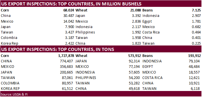
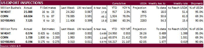
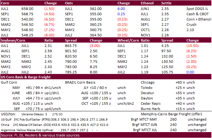
USDA
inspections versus Reuters trade range
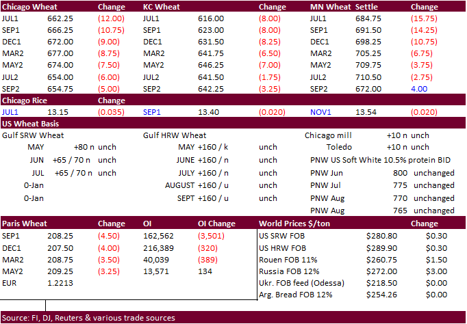
Wheat
573,912 versus 425000-625000 range
Corn
1,727,878 versus 1700000-2200000 range
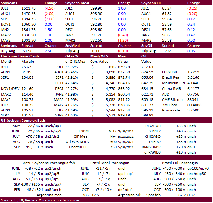
Soybeans
193,912 versus 150000-250000 range
- CBOT
corn was lower on improving weather and US plantings nearing an end. Bottom picking paired some of the losses for old crop, in part to ongoing concerns over tightening of US stocks before harvest. China’s vague statement on clamping down on rising commodity
prices was read by some as they may cool imports of agriculture commodities. We see the opposite as they could import cheaper corn, wheat, and soybeans to help tame rising inflation.
- Funds
sold an estimated 9,000 corn contracts, per Reuters. - News
was light with many countries on holiday. - We
see support in July corn around $6.21, then $6.05. - USDA
US corn export inspections as of May 20, 2021 were 1,727,878 tons, within a range of trade expectations, below 1,983,459 tons previous week and compares to 1,097,249 tons year ago. Major countries included China for 774,407 tons, Mexico for 356,683 tons, and
Japan for 200,665 tons. - South
Africa’s Crop Estimates Committee (CEC) will update their 2020-21 SAf corn production estimate on May 27 and a Reuters poll looks for production to expand to 16.413 million tons (9.131MMT yellow/7.287 white) from 16.095 million last month, and up from 15.300
million previous season. - Bloomberg
in a recap via Somar Meteorologia noted “freezing temperatures may intensify in the highlands of Parana, Santa Catarina and Rio Grande do Sul, posing frost risk, while the cold snap could weaken in corn areas of west of Parana and south of Mato Grosso do Sul
on Tuesday.”
Export
developments.
- None
reported
Updated
5/24/21
July
is seen in a $6.00 and $7.25 range (unchanged, down 50 cents)
December
corn is seen in a $4.75-$7.00 range.
- CBOT
soybean complex traded lower in all months to start on favorable US weather but new-crop contracts paired losses to end higher. New-crop soybean/new-crop corn spreading was likely. Soybean meal ended higher with bull spreading a feature, and soybean oil
mixed with nearby contracts under pressure on slowing export demand and slight correction to spreads. The 6-10 day precipitation outlook calls for rain to fall across the ECB, which is welcome. Palm futures fell over 100 points after dropping 11 percent
last week, despite higher energy futures. - Support
for July soybeans is seen at $14.8750, then $14.725. - Funds
sold an estimated net 2,000 soybeans, 3,000 meal and 1,000 soybean oil. - USDA
US soybean export inspections as of May 20, 2021 were 193,912 tons, within a range of trade expectations, below 310,408 tons previous week and compares to 343,698 tons year ago. Major countries included Indonesia for 79,104 tons, Egypt for 48,484 tons, and
Mexico for 18,557 tons. - An
India government report noted domestic retail vegetable oil prices are up 62 percent from a year ago. The food secretary asked the states and industry stakeholders to use measures to soften the prices. Details of a plan were lacking.
- APK-Inform:
Ukraine sunflower oil prices declined $20/ton to $1,535-$1,555 a ton FOB Black Sea.
- USDA
last week bought 4,970 tons of packaged vegetable oil for the educational program under the PL480 program at mostly $2,107.86 to $2,643.01/ton.
Updated
5/19/21
July
soybeans are seen in a $15.00-$16.50; November $12.75-$15.00
Soybean
meal – July $380-$440; December $380-$460
Soybean
oil – July 64-70; December 48-60 cent range
- Wheat
traded sharply lower early but some of the losses were paired from bottom picking. Improving US and Black Sea weather was theme today along with competitive export prices for the Black Sea region. Chicago hit a one-month low. We see July Chicago support
at $6.35. EU wheat hit a one-month low and closed at 208.25 euros, down 4.50. Chicago and MN ended more than 10 cents lower in the nearby months and KC July fell 8.75 cents.
- Funds
sold an estimated net 4,000 SRW wheat contracts. - Egypt
bought 240,000 tons of wheat that included Romanian origin, a sign Black Sea export competition will be a little more active with exporting countries other than Russia and Ukraine dominating the market. Egypt has enough wheat reserves to last 5.9 months.
- USDA
US all-wheat export inspections as of May 20, 2021 were 573,912 tons, within a range of trade expectations, below 660,298 tons previous week and compares to 464,857 tons year ago. Major countries included Japan for 92,314 tons, Mexico for 77,194 tons, and
Indonesia for 57,605 tons. - Ukraine’s
AgMin sees 2020-21 barley exports at 4.15 million tons from previous 4.0 million. They increased their grain export outlook to 45.817 million tons from 45.667 million tons. Wheat was unchanged at 17.5 million tons and corn at 23.5 million tons. - APK-Inform:
FOB Black Sea port wheat down $6 from previous week to $263-$270/ton. - IKAR:
Russian export prices for wheat down $12/ton to $260/ton.
- Egypt’s
GASC bought 240,000 tons of Romanian wheat for shipment Aug. 8-22. - 60,000
tons of Romanian wheat at $254.00 + $19.00 freight = $273.00 - 60,000
tons Romanian wheat at $258.80 + $19.00 freight = $ 277.80 - 120,000
tons of Romanian wheat at $258.80 + $19.00 freight = $277.80 - Saudi
Arabia’s Salic bought 60,000 tons of Australian wheat for delivery in June.
- Jordan
seeks 120,000 tons of feed wheat on May 26 for Oct-Nov shipment. - Bangladesh
seeks 50,000 tons of milling wheat on May 30. - USDA
seeks 83,000 tons of hard red winter wheat for Africa on May 25 for July 6-16 shipment.
Rice/Other
·
None reported
Updated
5/24/21
July
Chicago wheat is seen in a $6.30-$7.15 range
July
KC wheat is seen in a $5.95-$6.70
July
MN wheat is seen in a $6.55-$7.40
Terry Reilly
Senior Commodity Analyst – Grain and Oilseeds
Futures International
One Lincoln Center
18 W 140 Butterfield Rd.
Oakbrook Terrace, Il. 60181
W: 312.604.1366
ICE IM:
treilly1
Skype: fi.treilly

Trading of futures, options, swaps and other derivatives is risky and is not suitable for all persons. All of these investment products are leveraged, and you can lose more than your initial deposit. Each investment product is offered
only to and from jurisdictions where solicitation and sale are lawful, and in accordance with applicable laws and regulations in such jurisdiction. The information provided here should not be relied upon as a substitute for independent research before making
your investment decisions. Futures International, LLC is merely providing this information for your general information and the information does not take into account any particular individual’s investment objectives, financial situation, or needs. All investors
should obtain advice based on their unique situation before making any investment decision. The contents of this communication and any attachments are for informational purposes only and under no circumstances should they be construed as an offer to buy or
sell, or a solicitation to buy or sell any future, option, swap or other derivative. The sources for the information and any opinions in this communication are believed to be reliable, but Futures International, LLC does not warrant or guarantee the accuracy
of such information or opinions. Futures International, LLC and its principals and employees may take positions different from any positions described in this communication. Past results are not necessarily indicative of future results.