PDF Attached
Calls:
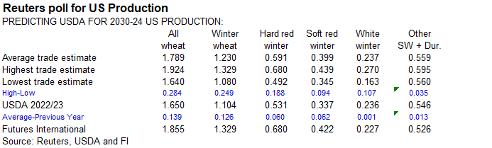
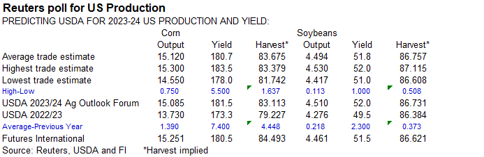
(planting progress, polls for USDA and weather are drivers)
Soybeans
unchanged to 3 lower
Corn
unchanged to 2 lower
Wheat
down 2-4 (predicated on good rain for US WW areas)
Quiet
session with selected countries on holiday. Choppy trade occurred for the CBOT agriculture markets, in part to profit taking from a few rallied late last week (SBO for example) and positioning ahead of many reports due out this week. Reuters and other polls
are expected to show a large discrepancy for the low and high end of trade expectations. This could create some volatility when new-crop USDA numbers are released on Friday. US CPI will be updated on Wednesday. StatsCan Canadian stocks will be updated Tuesday.
There was some chatter over ENSO patterns today with heat waves rolling across Asia. Something to monitor long term.
El
Nino versus La Nina – North American Northern Hemisphere refresher:
WEATHER
TO WATCH
-
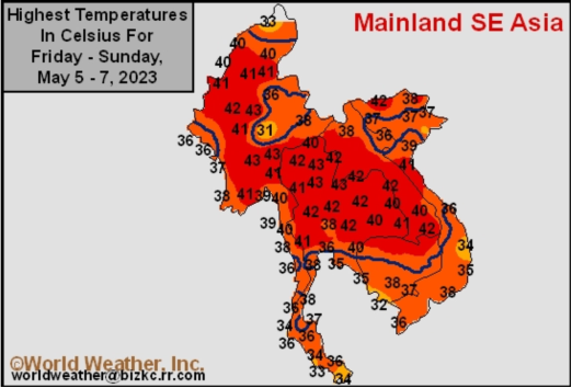
Excessive
heat occurred in Thailand, Vietnam, Laos and Cambodia during the weekend with extreme highs of 36 to 111 degrees Fahrenheit -
Records
were set because of the heat and stress to many crops (including coffee, citrus, sugarcane and corn) resulted
-
Mainland
areas of Southeast Asia are expected to see frequent rainfall over the next five days improving topsoil moisture as pre-monsoonal precipitation slowly increases -
A
tropical cyclone passing through Myanmar to southwestern China may lead to another bout of drier and warmer weather briefly during the weekend and early next week -
India
weather is expected to be mostly normal over the next ten days with a few pre-monsoonal showers and thunderstorms expected in the south and extreme east while most other areas are dry -
A
tropical cyclone will evolve in the Bay of Bengal this week and could impact Myanmar and/or Bangladesh and a part of India’s Far Eastern States late this week and into the weekend -
Very
poor model agreement on this system is present today and the forecast should be closely monitored for changes -
Indonesia/Malaysia
weather is still favorably wet through the next ten days -
Recent
rainfall was most significant in Indonesia and Malaysia while the Philippines dried down for a while -
This
trend may be perpetuated over the next couple of weeks -
China
weekend rainfall was abundant to excessive in areas south of the Yangtze River where flooding resulted.
-
One
location in northwestern Fujian reported 28.50 inches of rain since Friday and another in Jiangxi reported 27.32 inches while most other areas in Hunan, Jiangxi, Fujian and western Zhejiang reported 3.00 to 8.00 inches.
-
Damage
to maturing rapeseed and some early season rice likely resulted -
Rain
also fell from eastern Sichuan and far western Hubei through Shaanxi to Shanxi where 2.00 to more than 5.16 inches resulted in some areas.
-
Limited
rainfall occurred elsewhere in China with Yunnan and much of the North China Plain dry or mostly dry as were Heilongjiang, central and northern Jilin and much of Inner Mongolia. -
Drought
in Yunnan, China will finally be eased late this week and into the weekend as moderate rain finally falls -
Rice,
corn and sugarcane among other crops will benefit, though it has been dry enough for a long enough period of time for production to be hurt -
Additional
rain will be needed -
China’s
greatest rain over the next ten days will be in the southwest where 2.00 to 6.00 inches and locally more than 8.00 inches will result -
Some
flooding is expected -
Rapeseed
areas will see less frequent and less significant rain which may help stop the damage that has occurred recently from excessive rainfall and flooding -
Xinjiang,
China was unusually cool during the weekend -
Northeastern
areas reported highs in the 40s western areas reported highs in the 50s and 60s with a few readings to 73 Fahrenheit -
Summer
crop conditions are not very good because of the cool start to the planting season; both cotton and corn need much warmer weather -
Xinjiang,
China temperatures will trend warmer during the middle to latter part of this week with temperatures returning to normal by the weekend
-
A
meld to warm temperature regime is likely thereafter through most of next week -
Drought
relief is expected in northeastern Algeria and Tunisia this week with rainfall of 0.50 to 1.50 inches and local totals over 2.00 inches -
Dryness
has already hurt production this year, but there might be a few crops that can still benefit from the moisture boost -
Other
areas in North Africa and in much of Spain will be dry -
Eastern
Spain may get a few showers of benefit this week while most key crop areas stay dry -
Europe’s
greatest precipitation through May 20 will be from southeast to northwest where 1.00 to 3.00 inches will impact many areas with a few areas from Italy and the Alps into the western Balkan Countries getting 3.00 to more than 5.00 inches
-
Some
local flooding is possible -
Northeastern
Europe will not receive nearly as much rain -
Northwestern
Kazakhstan and neighboring southern areas of Russia’s eastern New Lands will get some rain this week with 1.00 to nearly 2.50 inches possible in a few areas, but most of the precipitation will be lighter leaving some need for more moisture -
A
close watch on this region is warranted because of decreasing topsoil moisture recently and additional warm and dry biased weather expected in the same areas again this weekend into most of next week -
Other
western CIS crop areas will likely benefit from a drier bias over the next week to ten days -
Canada’s
Southwestern Prairies will continue drought stricken through the next two weeks, despite a few showers periodically -
Canada’s
eastern and far western Prairies may experience some planting delay because of periodic rainfall, this week although the impact will be low -
A
new wave of heat and dryness is expected near and beyond mid-month, impacting Alberta and western Saskatchewan more than areas to the east -
Ontario
and Quebec, Canada will experience a more seasonable temperature regime this week after being cooler and wetter than usual recently -
Drier
and warmer weather is needed to induce a better environment for wheat development and spring planting that often begins around mid-month -
Warming
is expected soon -
U.S.
weekend precipitation was greatest in the northern Plains and northern Midwest as well as the Pacific Northwest, including northern California -
Rainfall
was erratically distributed with some totals of 0.50 to 1.65 inches from Nebraska to eastern and south-central South Dakota and in northwestern Minnesota -
Rainfall
of 0.50 to 2.00 inches also occurred in parts of Wisconsin, eastern Iowa and from southeastern Illinois to eastern Ohio northward into south-central Michigan -
Rainfall
of 1.00 to 2.00 inches also occurred in sugarcane areas of Louisiana and eastward into southern most Mississippi while the Blacklands of Texas reported 0.30 to 1.00 inch with one location in central Texas getting 2.19 inches -
Kansas
and Colorado through western Texas was dry along with the lower Midwest, Tennessee River Valley and northern Delta as well as the southeastern states -
Northern
California received 1.00 to 2.26 inches of moisture -
U.S.
temperatures were hot in the southern Plains with 80- and 90-degree highs from Kansas and Missouri to southern Texas -
Extreme
highs over 100 Fahrenheit occurred in a few Texas Oklahoma and readings reached 97 in southeastern wheat areas of Kansas -
U.S.
temperatures will continue above normal in the central and southern Plains and a part of the western Corn Belt for while this week -
Additional
highs in the 80s and 90s are expected and some of the heat will expand into the southeastern states -
70-
and 80-degree highs are expected in the Midwest later this week as well -
The
warmth will accelerate drying rates between rain events -
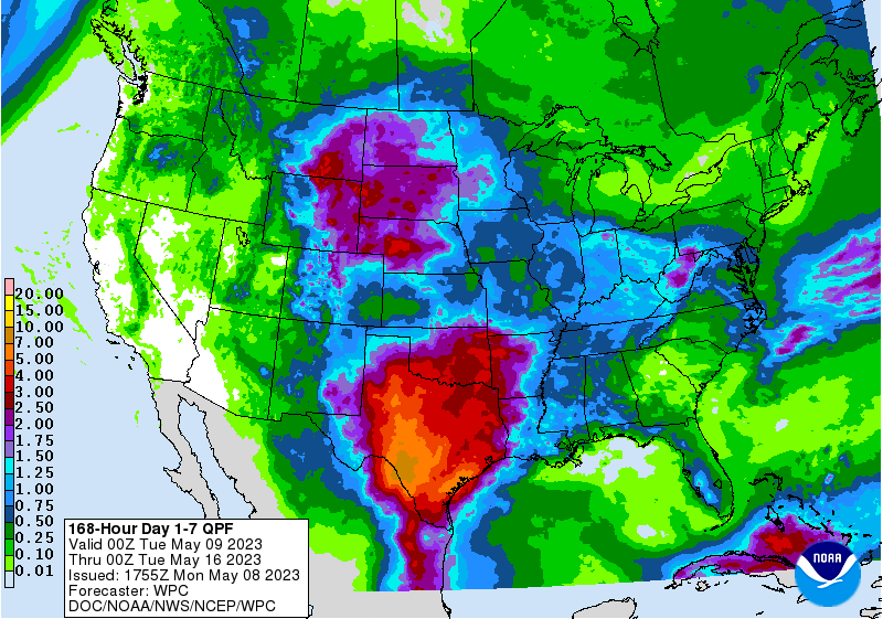
U.S.
rainfall is expected in all major crop areas at one time or another during the next ten days; including hard red winter wheat areas, West Texas and a part of the northwestern Plains all of which have been drier than usual at times.
-
Rainfall
may be heavy at times in central, eastern and southern Texas -
Sufficient
amounts are expected in the northern Plains and upper Midwest to keep farmers out of their fields for a while -
Eastern
Midwest and southeastern states rainfall may be lightest and least frequent -
No
rain is expected in the southwestern states -
Hard
red winter wheat areas will get 0.10 to 0.75 inch in the west-central Plains with some areas failing to get enough rain to counter evaporation while other areas receive 0.60 to 1.50 inches and a number of areas in the east and south will get over 2.00 inches -
Western
Nebraska and northeastern Colorado may also get some significant rain -
West
Texas rainfall may range from 1.00 to 2.00 inches and locally more with much of that occurring this coming weekend into early next week
-
Central
and eastern Argentina received some welcome rain during the weekend easing dryness -
Areas
east of a line from northwestern Cordoba to central Buenos Aires were wettest with 0.20 to 0.60 inch common and some areas from Santa Fe to northeastern Buenos Aires and Entre Rios receiving 0.60 to 1.69 inches
-
Summer
crop harvesting was disrupted, but the moisture was good for future wheat planting if there is some follow up moisture -
Southwestern
Argentina was left dry -
Argentina
will be mostly dry through May 19 favoring the resumption of summer crop harvesting and drying trend in the soil again -
Temperatures
will be near to above normal with the warmest weather likely during the weekend and next week -
Brazil
weather during the weekend was dry in much of center west and center south crop areas where it should remain dry or mostly dry over the next two weeks -
Drying
is normal for this time of year, though late planted Safrinha crops will require moisture late this month and in June to ensure the best yield potentials. -
Rio
Grande do Sul, Brazil received significant rainfall during the weekend with 1.00 to 2.83 inches reported through Sunday morning.
-
The
moisture was good for late season crops, but some drying is now needed -
Rain
will linger into Monday in Rio Grande do Sul, Brazil and then it, too, will dry out over the coming ten days -
Rain
is expected in Bahia and Tocantins during mid- to late-week this week causing a disruption to farming activity; including the harvest of cotton, sugarcane and coffee -
Most
of the rain is not likely to be heavy -
West-central
Africa will continue to experience periodic rainfall over the next two weeks maintaining a mostly good environment for coffee, cocoa, rice and sugarcane -
Mali
and Burkina Faso rainfall will remain lighter than usual, although some welcome precipitation is expected that will raise topsoil moisture.
-
East-central
Africa rainfall will continue periodic and mostly in a beneficial manner to support rice, coffee, cocoa, sugarcane and other crops -
South
Africa rainfall increased during the weekend slowing summer crop maturation and harvest progress -
Some
rain will continue early this week followed by some welcome drying -
Harvest
delays will continue for a while, though some winter crops might benefit from the moisture in Free State -
Far
western parts of the nation where most of the wheat and canola is produced will be left dry -
Australia
rainfall during the coming week will be greatest in winter crop areas near to the coast.
-
Moisture
totals will be light and a boost in rainfall will continue to be needed in interior Western Australia, interior South Australia and western New South Wales -
Drought
continues in central and western Mexico while recent rain in the east has improved crop and field conditions -
Central
Asia cotton and other crop planting is under way and advancing relatively well with adequate irrigation water and some timely rainfall expected -
Today’s
Southern Oscillation Index was -0.91 and it should move erratically over the next several days
Source:
World Weather, INC.
7-day
Bloomberg
Ag calendar
Monday,
May 8:
- USDA
export inspections – corn, soybeans, wheat, 11am - US
winter wheat condition, 4pm - US
planting data for corn, cotton, spring wheat and soybeans, 4pm - HOLIDAY:
UK, France
Tuesday,
May 9:
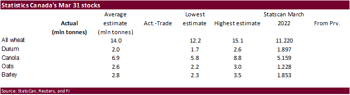
- Canada’s
StatsCan to release wheat, soybean, canola and barley reserves data - China’s
first batch of April trade data, including soybean, edible oil, rubber and meat imports
Wednesday,
May 10:
- EIA
weekly US ethanol inventories, production, 10:30am - Malaysian
Palm Oil Board’s data for May output, exports and stockpiles - Malaysia’s
May 1-10 palm oil exports - Sugar
production and cane crush data by Brazil’s Unica (tentative)
Thursday,
May 11:
- USDA
weekly net-export sales for corn, soybeans, wheat, cotton, pork and beef, 8:30am - Port
of Rouen data on French grain exports - Brazil’s
Conab issues production, area and yield data for corn and soybeans - New
Zealand Food Prices - EARNINGS:
GrainCorp
Friday,
May 12:
- USDA’s
World Agricultural Supply and Demand Estimates (WASDE), 12pm eastern - China’s
agriculture ministry (CASDE) releases monthly report on supply and demand for corn and soybeans - ICE
Futures Europe weekly commitments of traders report - CFTC
commitments of traders weekly report on positions for various US futures and options, 3:30pm - FranceAgriMer’s
weekly crop condition report
Source:
Bloomberg and FI
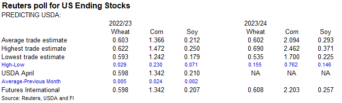
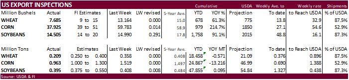
USDA
inspections versus Reuters trade range
Wheat
209,138 versus 200000-500000 range
Corn
963,351 versus 1000000-1550000 range
Soybeans
394,755 versus 300000-600000 range
Inspections
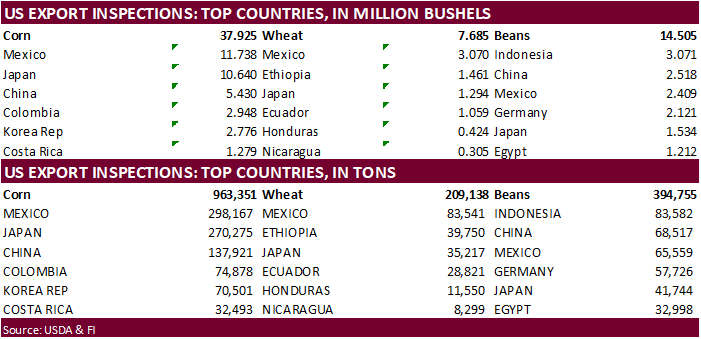
for corn fell short of expectations. China slipped to number 3 for top US corn export destination. Soybeans are starting to slow, and wheat came in lower end of a range of expectations.
GRAINS
INSPECTED AND/OR WEIGHED FOR EXPORT
REPORTED IN WEEK ENDING MAY 04, 2023
— METRIC TONS —
————————————————————————-
CURRENT PREVIOUS
———–
WEEK ENDING ———- MARKET YEAR MARKET YEAR
GRAIN 05/04/2023 04/27/2023 05/05/2022 TO DATE TO DATE
BARLEY
0 0 0 2,154 10,156
CORN
963,351 1,518,569 1,477,246 24,866,729 38,082,798
FLAXSEED
0 0 0 200 324
MIXED
0 0 0 0 0
OATS
100 0 0 6,586 600
RYE
0 0 0 0 0
SORGHUM
49,588 112,824 270,492 1,467,095 5,577,413
SOYBEANS
394,755 407,973 506,939 47,854,601 47,759,661
SUNFLOWER
100 0 0 2,508 2,260
WHEAT
209,138 358,273 262,919 18,458,158 19,028,658
Total
1,617,032 2,397,639 2,517,596 92,658,031 110,461,870
————————————————————————-
CROP
MARKETING YEARS BEGIN JUNE 1 FOR WHEAT, RYE, OATS, BARLEY AND
FLAXSEED;
SEPTEMBER 1 FOR CORN, SORGHUM, SOYBEANS AND SUNFLOWER SEEDS.
INCLUDES
WATERWAY SHIPMENTS TO CANADA.
Macros
104
Counterparties Take $2.218 Tln At Fed Reverse Repo Op. (prev $2.207 Tln, 101 Bids)
Corn
·
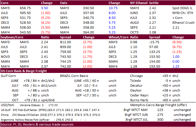
Corn ended unchanged for July and lower for the back months despite slowing nearby US corn exports. There were no export developments over the weekend. US inspections were lower than what we projected.
·
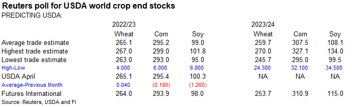
USDA could lower US corn exports by 25 to 50 million bushels this Friday (50 bias, up from 25 million estimated last week). A Reuters trade average for 2022-23 corn stocks has a 25 million bushel reduction, on average. Slowing
inspections and commitments from the onset of a record Brazil crop and US export price premiums versus South America could be cited, when updated by USDA.
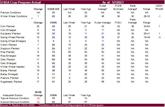
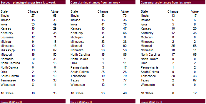
·
Trade estimates for corn plantings ranged from a large 34 to 64 percent (soybeans 25-41 percent). Some dry areas of the WCB saw little plantings while ECB rolled on. We are hearing southern IL is done with corn planting progress.
·
El Nino is gaining strength. We see no short-term issue now for US crops but excessive heat in Asia right now is not a good sign for the US summer growing season and the trade needs to take note.
·
Brazil’s corn area will dry down this week.
·
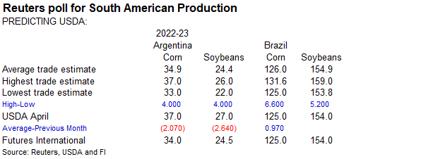
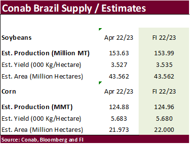
Safras & Mercado estimated Brazil producers sold 24.3% of their record large second corn crop versus 31 percent year ago. Volume is higher than a year ago. They are using a 92.2 MMT second corn crop estimate. Conab will be out
with an update this week (estimates above).
·
(Reuters) –{CME hogs finished higher Monday….} Chicago Mercantile Exchange lean hog futures sank to contract lows on Friday on concerns over anemic U.S. demand for pork, analysts said…”Retail prices for pork are still too high
to attract sustained consumer demand at a time when many families are struggling to make ends meet.”
·
We suspect cattle on feed across the US is higher than USDA’s projection relative to inventories due to the ongoing drought, but cattle inventories as whole are down. Tyson noted they paid a lot more for live cattle last quarter
due to tighter supplies. Volume might not be down but margins for the meat industry are getting tighter. Look for higher US retail meat prices over the medium term, passed down to the consumer. USDA currently projects feed grains used for consuming animal
units at a 5-year low.

Export
developments.
-
Results
awaited: Algeria seeks up to 140,000 tons of corn for May through August shipment. Late last week they bought an undisclosed amount of milling wheat.
Updated
05/02/23
July
corn $5.00-$6.50
December
corn $4.75-$6.50
·
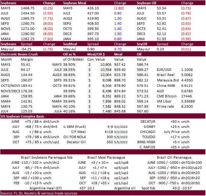
Short covering and higher soybean oil lifted soybeans higher overnight but prices dropped on fund selling despite a higher outside market related trade, at least for soybean oil. Note Friday prices for SBO were sharply higher.
Soybeans closed lower (non-expiring) and SBO near session lows. Meal was moderately higher as corn closed mixed.
·
There was a big drop in rapeseed futures in Euronext today just before close.
·
US soybean inspections were lower than what we projected.
·
Brazil soybean premiums were mixed, meal higher and soybean down sharply.
·
US soybean oil exports should fall short of USDA’s 500 million pound level (1.773 billion for 2021-22), based on USDA’s latest export sales report showing accumulated exports to date at a low 57.4 thousand tons, well below 528,700
tons a year ago. Outstanding sales are 60,100 tons versus 136,400 year earlier, but like corn, don’t rule out cancelations. Western soybean oil is around 500 over and Gulf SBO basis jumped about 100 to 350 over as of last Friday. US soybean oil is too expensive
relative to SA and competing overseas rapeseed oil, sunflower and palm oil. USDA may address this later rather than on Friday as the crop year ends October.
Export
Developments
-
Results
awaited: Algeria seeks up to 70,000 tons of soybean meal for June through July 15 shipment.
-
USDA
seeks 120 tons of packaged vegetable oil for various export programs on May 16 for June 16-July 5 shipment.
-
Last
week USDA bought 260 tons of vegetable oil for export programs at $1,998.33 per tons.
Updated
05/05/23
Soybeans
– July $13.75-$15.25, November $12.00-$15.00
Soybean
meal – July $375-$475, December $325-$500
Soybean
oil – July 50-56,
December 48-58
·
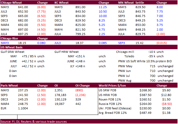
US wheat futures started higher on Black Sea shipping concerns, but Chicago fell from fund selling. Improving US weather and a lower Paris wheat market pressured Chicago but did little to stop speculative buying for KC and Chicago.
·
Ukraine blamed Russia of stopping Black Sea incoming ship registrations. Meanwhile negotiations over the grain deal resumed today. Look for headline trading to continue to dominate price direction this week.
·
US all-wheat inspections were lower than what we projected.
·
90 ships are awaiting approval in Turkish waters to enter Ukraine, including 62 for loading. May 18 is the deadline for the grain deal.
·
Most of the US will see rain one time or another this week, lighter bias the west-central Plains.
·
Texas and Colorado will see most of the projected rains over the next seven days, which is welcome.
·
We speculate the rains this week are too late for some wheat areas. A Reuters story covering a southwestern KS producer cited 85% abandonment from the drought. KS, OK, and TX have been hardest hit this year. High winds this season
have not helped.
·
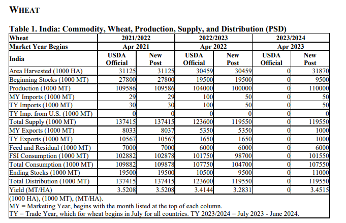
The USDA Attaché estimated India wheat production for 2023-24 at 110 million tons, up from their 100 million tons estimate for 2022-23 (USDA official 104MMT).
https://apps.fas.usda.gov/newgainapi/api/Report/DownloadReportByFileName?fileName=Grain%20and%20Feed%20Update_New%20Delhi_India_IN2023-0032
·
Egypt said their wheat reserves are currently at 4.1 months after securing 1.2 million tons of local wheat so far this season.
·
We look for an improvement of 2 points for the G/E categories for winter wheat when updated after the close.
·
September Paris wheat futures were 2.50 euros lower at 241.50 euros.
Export
Developments.
·
Algeria seeks at least 50,000 tons of soft milling wheat, optional origin, on May 10/11th, for July shipment. Earlier shipment if from SA and/or Australia.
·
Jordan seeks 120,000 tons of feed barley on May 10 for October 16-31 and November 1-15 shipment.
Rice/Other
·
China sold 70,936 tons of rice out of auction at an average price of 2,522 yuan per ton. This represented 7.85 percent of what was offered.
Updated
05/05/23
KC
– July $7.50-8.75
MN
– July
$7.50-9.00
#non-promo