PDF Attached
World
Weather Inc.
-
Thailand
continues to receive less than usual pre-monsoonal precipitation raising some concern over sugarcane, rice and corn development -
Some
increase in precipitation is expected in this next ten days, although grater rain may still be required -
Australia
sugarcane production areas have also experienced less than usual rainfall in recent weeks and months -
The
drier than usual bias will likely continue for an extended period of time -
Spain
and Portugal as well as North Africa crop areas will continue to be drier than usual over the next ten days, although a few showers will be possible -
Argentina
rainfall will continue lighter than usual through the next two weeks resulting in a very good environment for summer crop maturation and harvest progress -
Some
periodic rain is anticipated, but the disruptions to fieldwork will be brief and no harm will come to summer crop conditions -
Brazil
weather will continue to be favorable over the next two weeks -
Timely
rainfall is expected in Mato Grosso during the next week to ten days favoring Safrinha cotton and corn development -
Soil
moisture elsewhere will be sufficient to carry on normal crop development in areas where corn, rice, sugarcane, coffee and citrus is still developing -
Winter
crop planting should advance swiftly -
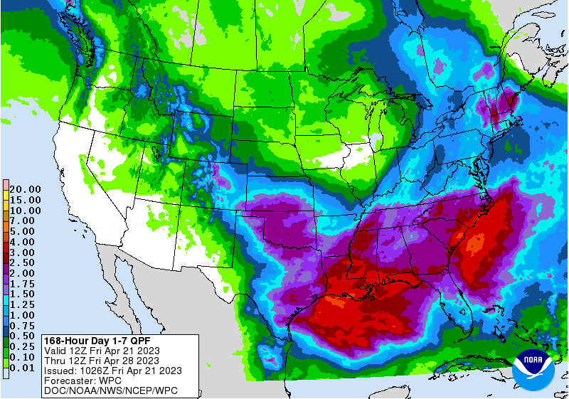
U.S.
hard red winter wheat areas will get welcome rainfall during the next ten days -
Three
waves of rain will bring moisture to all of the production region. -
0.50
to 1.50 inches will be common with amounts of 1.50 to nearly 3.00 inches possible in eastern parts of central Kansas and central Oklahoma by the end of this month -
The
greatest amounts may not be widespread, but all of the moisture will be good for improved wheat development and for the planting and emergence of summer crops -
U.S.
Northeastern Plains and Upper Midwest crop areas will continue to deal with flooding for a while and the current storm system in the region will diminish from west to east later today and Saturday -
Another
upper level low pressure center will bring cloudiness, periods of rain and some wet snow late next week and into the following weekend -
After
this system passes the upper Midwest and northeastern Plains, as well as eastern Canada’s Prairies will see less precipitation and warmer temperatures – at least for a while -
U.S.
Delta is expecting more rain today and then additional moisture during mid-week next week and possibly again in the following weekend -
The
moisture will occur often enough to slow some fieldwork, but some field progress will occur around the moisture
-
U.S.
southeastern states will experience a good mix of rain and sunshine over the next ten days -
Cold
temperatures in the north half of the U.S. Plains and Midwest this weekend will not induce any serious harm to winter crops and most early emerging summer crops may not be seriously impacted -
However,
some of the early emerged corn fields may not perform well for a while due to cool temperatures that will dominate the next couple of weeks -
California
and the southwestern desert region will be dry and warm for an extended period of time -
Brief
periods of rain and mountain snow will impact the U.S. Pacific Northwest during the coming week followed by drier biased weather in the last week of this month -
U.S.
temperatures will be colder than usual over a bit part of the nation during this first week of the outlook and then the cooler bias will shift to the east allowing the western states to trend warmer -
Early
May temperatures are advertised to be much closer to normal -
Drought
will continue in the southwestern Canadian Prairies, although a few brief bouts of very light precipitation are expected -
Western
Canada’s Prairies will warm up nicely next week resulting in aggressive fieldwork due to limited precipitation -
Planting
will increase across much of Alberta, despite ongoing dryness in parts of the east-central and interior south -
However,
additional delays in planting are probable for the areas with the absolute worst moisture profile in east-central and interior southern Alberta -
Eastern
Canada’s Prairies will experience more snow today and then drier weather through the first half of next week -
A
new storm system may generate additional wet weather late next week and into the following weekend further delaying the opportunity for spring fieldwork -
India’s
weather will be favorable in this first week of the outlook, but the second week forecast could end up wet and stormy with cooler than usual temperatures -
There
is time for this forecast to change, but the situation needs to be closely monitored because of the potential wet and stormy conditions would have on unharvested winter crops
-
Northern
Kazakhstan and western portions of the eastern Russia New Lands are expecting drier and warmer biased weather beginning next week and lasting for a week to perhaps ten days -
The
drying bias will firm the soil and warm it in support of spring planting -
Timely
rain will become imperative for crops once they are planted due to lower soil moisture that is expected to be prevailing at that time -
Most
of Europe and the western CIS outside of the Iberian Peninsula and parts of the Russian New Lands are experiencing favorable crop weather with little change likely for a while -
Temperatures
will continue near to above normal in southwestern Europe and over portions of the western CIS with cool conditions in between
-
Excessive
soil moisture and some flooding evolved recently near and south of China’s Yangtze River and additional precipitation is forthcoming -
Damage
may have occurred to some rapeseed, rice and other crops in the region, although most of the impact should have been localized -
Xinjiang,
China has turned warmer in recent days improving cotton, corn and other spring and summer crop planting conditions -
Northeast
parts of the province will see waves of rain and cooler weather over the next two weeks while weather in western production areas are mostly dry and warm, although not quite as warm as usual -
Yunnan,
China is too dry and needs moisture for early season corn and rice as well as other crops -
The
province and neighboring areas are considered to be in a drought -
Dryness
will continue in the province cutting into rice and corn planting and production potential as well as some other crops -
Ontario
and Quebec, Canada soil temperatures warmed in favor or new wheat development recently, but cooling is expected in the coming week to ten days that will shut down new crop development and lower soil temperatures -
Middle
East rainfall is expected most often in Turkey while most other areas receive only infrequent showers
-
Cotton
and rice planting have benefitted from recent rain -
Winter
crops will fill favorably, but drier weather may soon be needed to protect grain quality -
Australia
precipitation has been limited recently, but rain will evolve in the south next week to moisten the topsoil once again and allow better planting and emergence conditions.
-
Favorable
summer crop maturation and harvest progress is expected in the east-central parts of the nation
-
Western
Australia is the state to watch for possible drying in the next few weeks, although southern areas will get a little rain early next week -
South
Africa precipitation should be restricted for a while favoring summer crop maturation and harvest progress -
Mainland
areas of Southeast Asia are still in need of greater rain, although the situation is not critical
-
Poor
pre-monsoonal shower and thunderstorm activity has been occurring in many areas and improved rainfall will soon be needed -
This
is impacting some early season sugarcane, rice and coffee development as well as other crops -
Thailand
is among the drier areas -
Some
improved rainfall is expected over the coming week -
Indonesia
and Malaysia weather has been lighter than usual due to the negative phase of Madden Julian Oscillation, but a change is expected that will allow improving rainfall to evolve gradually over the next week to ten days -
Cotton
areas from Mali to Burkina Faso have not seen a normal start to the rainy season this year; rain is needed to support planting -
Some
rain will fall in the second week of the outlook especially in Burkina Faso -
Other
west-central Africa coffee and cocoa production areas will receive routinely occurring showers and thunderstorms
-
East-central
Africa precipitation will be sufficient to support favorable coffee, cocoa and, rice and sugarcane development as well as other crops -
Mexico
remains in a drought, though eastern and far southern parts of the nation will get some periodic rain -
Central
Asia cotton and other crop planting is under way and advancing relatively well with adequate irrigation water and some timely rainfall expected -
Today’s
Southern Oscillation Index was -0.95 and it should move notably lower over the next few days.
Source:
World Weather, INC.
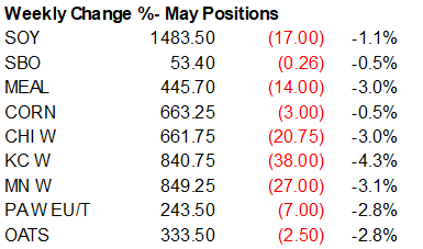
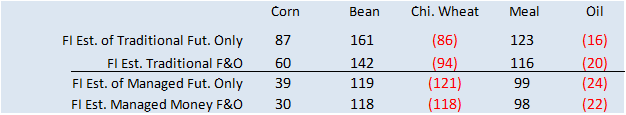
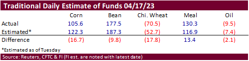
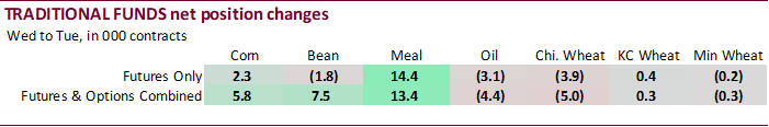
Funds
were less long for corn, soybeans and soybean oil while less short than expected for wheat and more short than expected for soybean oil. We don’t see a price impact from the weekly COT report.


Reuters
table
SUPPLEMENTAL
Non-Comm Indexes Comm
Net Chg Net Chg Net Chg
Corn
-19,230 -8,733 317,840 18,850 -236,128 -8,846
Soybeans
111,256 9,265 137,204 -408 -217,618 -11,967
Soyoil
-37,354 -3,996 103,727 606 -69,760 -1,105
CBOT
wheat -89,421 -5,625 75,110 1,049 7,783 3,657
KCBT
wheat -10,309 -109 42,485 70 -31,986 148
FUTURES
+ OPTS Managed Swaps Producer
Net Chg Net Chg Net Chg
Corn
49,434 22,322 230,409 3,251 -246,614 -7,769
Soybeans
134,782 9,761 87,061 -2,446 -214,706 -8,166
Soymeal
105,682 10,003 90,575 314 -233,755 -12,609
Soyoil
-15,743 -3,178 108,008 2,168 -97,036 -2,275
CBOT
wheat -102,983 1,264 65,252 1,619 6,463 2,496
KCBT
wheat 10,591 1,362 32,860 -321 -34,172 176
MGEX
wheat 38 -207 1,226 19 -6,311 -296
———- ———- ———- ———- ———- ———-
Total
wheat -92,354 2,419 99,338 1,317 -34,020 2,376
Live
cattle 104,341 12,319 47,710 -367 -164,550 -10,817
Feeder
cattle 11,012 2,670 1,263 81 -3,455 -1,610
Lean
hogs -24,570 -20 46,875 36 -24,179 231
Other NonReport Open
Net Chg Net Chg Interest Chg
Corn
29,253 -16,534 -62,483 -1,270 1,690,262 9,235
Soybeans
23,705 -2,260 -30,843 3,111 856,008 -26,737
Soymeal
17,807 3,370 19,691 -1,077 504,548 18,616
Soyoil
1,384 -1,210 3,387 4,495 523,252 -4,880
CBOT
wheat 24,738 -6,296 6,529 918 458,928 -10,164
KCBT
wheat -9,090 -1,108 -190 -108 190,739 -2,342
MGEX
wheat 3,980 -88 1,066 572 61,157 -2,727
———- ———- ———- ———- ———- ———-
Total
wheat 19,628 -7,492 7,405 1,382 710,824 -15,233
Live
cattle 27,711 2,110 -15,210 -3,245 420,483 10,557
Feeder
cattle 2,535 -699 -11,354 -442 74,254 -572
Lean
hogs -4,315 -989 6,189 742 331,978 3,340
Bloomberg
Ag calendar
Monday,
April 24:
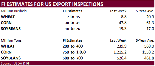
- USDA
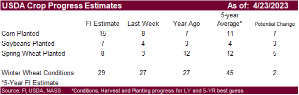
export inspections – corn, soybeans, wheat, 11am - US
planting data for corn, cotton, spring wheat and soybeans, 4pm - MARS
monthly report on EU crop conditions - US
winter wheat condition, 4pm - Cane
crush and sugar production data by Brazil’s Unica (tentative) - HOLIDAY:
Malaysia, Indonesia, Pakistan
Tuesday,
April 25:
- Malaysia’s
April 1-25 palm oil export data - Argus
Biofuels & Feedstocks Asia Conference, Singapore, day 1 - Commodity
Trading Week conference, London, day 1 - US
poultry slaughter; cold storage data for beef, pork and poultry, 3pm - HOLIDAY:
Australia, New Zealand, Pakistan, Indonesia
Wednesday,
April 26:
- EIA
weekly US ethanol inventories, production, 10:30am - Euro
Grain Hub Exchange & Forum, Bucharest, Romania, day 1 - Argus
Biofuels & Feedstocks Asia Conference, Singapore, day 2 - Commodity
Trading Week conference, London, day 2 - Canada’s
StatCan to release seeded area data for wheat, barley, canola and soybeans - Brazil’s
Conab to publish cane, sugar and ethanol production data
Thursday,
April 27:
- USDA
weekly net-export sales for corn, soybeans, wheat, cotton, pork and beef, 8:30am - Euro
Grain Hub Exchange & Forum, Bucharest, day 2 - Port
of Rouen data on French grain exports - Argus
Biofuels & Feedstocks Asia Conference, Singapore, day 3
Friday,
April 28:
- ICE
Futures Europe weekly commitments of traders report - CFTC
commitments of traders weekly report on positions for various US futures and options, 3:30pm - Euro
Grain Hub Exchange & Forum, Bucharest, day 3 - FranceAgriMer’s
weekly crop condition report - US
agricultural prices paid, received, 3pm
Saturday,
April 29:
- Vietnam’s
coffee, rice and rubber export data
Source:
Bloomberg and FI
The
CME group lowered margins for SBO, soybeans, corn, Chicago wheat, and KC wheat
https://www.cmegroup.com/notices/clearing/2023/04/Chadv23-130.html
Canada
Retail Sales M/M Feb: -0.2% (est -0.6%, prev 1.4%)
Canada
Retail Sales Fall 1.4% In March – Flash Estimate Stats Canada
Argentina
Central Bank Lifts Rate to 81% as Inflation Jumps – Bloomberg
105
Counterparties Take $2.290 Tln At Fed Reverse Repo Op. (prev $2.277 Tln, 103 Bids)
·
Asian interest for South American corn origin pressured US futures. US Gulf fob as of yesterday was around $276/ton and Brazil $253. SK floated three import tenders over the past 24 hours, all from SA when concluded.
·
There was heavy CBOT option call selling today, bias corn and soybeans.
·
Some speculate the Black Sea grain deal is winding down. Set to expire mid next month, look for major importers to be cautious committing to Black Sea grains under the existing deal.
·
Argentina’s BA Grains Exchange
kept their corn crop estimate at 36 million tons. They estimated harvest progress at 15 percent.
·
Ukraine’s grain exports so far this season amount to 40.6 million tons, down 11 percent from the same period a year ago.
Export
developments.
·
South Korea’s MFG group bought 69,000 tons of animal feed corn from South America at an estimated $266.95 a ton c&f for arrival in South Korea around Sept. 30.
·
South Korea’s Busan section bought 66,000 tons of animal feed corn from South America at an estimated $267.33 a ton c&f for arrival in South Korea around Sept. 30.
·
South Korea’s NOFI group bought an estimated 137,000 tons of feed corn, all optional origin, at an estimated $267.98/ton c&f. One cargo is for arrival around September 30 and second around October 5.
Updated
04/21/23
May
corn $6.45-$6.90
July
corn $5.75-$7.00
·
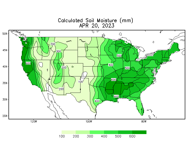
The CBOT soybean complex traded lower for the third consecutive day from slowing US exports (and Brazil shipping lineup showing soybeans bound for US) and improving weather particularly US Midwest – replenishing soil moisture
levels ahead of the bulk of planting season. May soybeans could test $14.50/bu by mid next week if US planting progress picks up and Brazilian sales increase. Concerns over China demand of soybeans may also pull prices lower next week.
·
US east coast end users have bought Brazil soybeans, at an unusually early time for any crop year. 79k tons of Brazilian soybean are on the shipping lineup, set for nearby sail from the port of Santarem, Brazil. US ECB soybean
supplies have been tight for months and rail costs to the eastern seaboard end users is not logistically favorable from the Midwest, at the moment, making purchases of cheaper Brazilian fob soybeans attractive. Soybean and Corn Advisory noted a $2.00 per bushel
discount between Brazil and US. Local east coast elevators and producers might be wishing this is not to become a norm.
·
ADM plant explosion at West Decatur plant in central IL. Spreads should be monitored. Details are lacking.
·
https://newschannel20.com/news/local/crews-respond-to-explosion-at-adm-plant-three-injured
·
Higher WTI crude oil was limiting losses for soybean oil, but the market crashed mid-morning on fund selling and lower soybean meal.
·
First Notice Day deliveries for the CBOT agriculture contracts is rapidly approaching. We see no soybean or soybean meal deliveries. There could be light corn and soybean oil contracts put out there. Chicago wheat may end up in
the 100 to 300 contract range.
·
China March soybean imports:
-
US
4.83MMT (3.37MMT year ago) -
Brazil
1.67 (off 43% year ago) -
Total
6.85MMT (up 8% from March 2022)
·
Argentina Central Bank Lifts Rate to 81% as Inflation Jumps – Bloomberg.
·
Argentina’s BA Grains Exchange lowered their soybean crop estimate to 22.5 million tons from 25 million previously, citing lower yields. About 17 percent of the crop had been collected.
·
Malaysia was on holiday today and will be on holiday the 24th.
Export
Developments
-
None
reported.
Updated
04/21/23
Soybeans
– May $14.50-$15.00, November
$12.25-$15.00
Soybean
meal – May $475-$460, December
$325-$500
Soybean
oil – May 52.50-54.00,
December
49-58
Wheat
·
US wheat futures traded two-sided, ending lower after on technical buying dried, and weakness in corn. Not much news was released Friday to sustain the earlier support.
·
Romania will not ban Ukraine grain imports and will wait for the EU to make a decision to help control the influx of Ukraine ag product imports that have made their way int eastern European countries.
·
Grain transit from Ukraine into Poland resumed, and Hungary’s feed & industrial end users now oppose the ban on Ukraine grain imports.
·
Ukraine has 1 million hectares of spring crops planted, a good start. The AgMin looks for a 1.4 million hectare decrease to 10.2 million this year, primarily in war.
·
September Paris wheat futures were lower by 4.75 euros to 243.50 euros per ton, lowest since March 2022.
·
French soft wheat crop conditions as of April 17 fell one point to 93% good/excellent from previous week and compares to 91 percent year ago.
·
TASS. The duty on wheat exports from Russia will amount to 5,678.9 rubles ($69.34) per metric ton from April 19 to 25, 2023, according to the Ministry of Agriculture. The duty on the export of barley will be 2,496 rubles ($30.48)
and for corn – 3,215.8 rubles ($39.3) per metric ton, the Ministry said.
·
IKAR: Russia wheat production 84 MMT and exports at 41 MMT.
Export
Developments.
·
China plans to sell 40,000 tons of wheat from state reserves on April 26.
·
Jordan seeks 120,000 tons of optional origin wheat on May 2.
·
Jordan seeks 120,000 tons of feed barley May 3 for October through FH November shipment.
Rice/Other
·
Brazil 2023/24 Coffee Sales 23% Done as of April 17: Safras (Bloomberg)
Updated
04/21/23
KC
– May $8.25-9.00
MN
– May
$8.40-$9.00
#non-promo