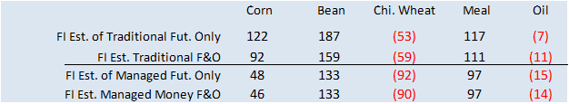
PDF Attached includes FI estimates for USDA export sales
Choppy
trade with soybeans ending higher led by slow Argentina producer selling and higher soybean oil. Wide two-sided trade in meal with a lower close on demand destruction. Corn ended moderately higher, Chicago wheat higher and high protein wheat lower.
World
Weather Inc.
-
Freezes
will occur this weekend in the Great Plains, Midwest and northern Delta -
Most
winter crops in the central Plains should not be harmed -
Concern
is moderate over crops in Oklahoma and southeastern parts of the Texas Panhandle where frost and some freezes are possible
-
Wheat
is booting and heading in some of these areas, although mostly south of where the more significant freezes are expected -
Oats
and rye are also heading in these warmer areas and canola is flowering; all of these crops are vulnerable to damage, but since the more advanced crops are in the south there is potential the only a few will be seriously impacted by the cold -
Northern
fringes of the Delta in Arkansas, southeastern Missouri as well as southernmost Illinois and Kentucky will be monitored for some damage, too -
Early
emerged corn will be negatively impacted by the cold, although the growing point should be below the surface of the soil keeping the potential for permanent damage low -
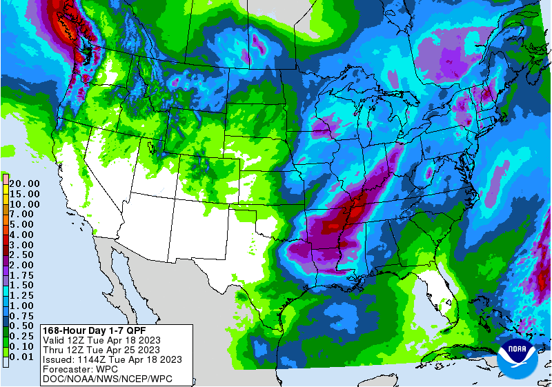
Rain
may return to the central and southern U.S. Plains next week as warmer air returns the Plains after weekend frost and freezes -
The
southwestern Plains are least likely to get a soaking of rain, but some showers are expected -
The
heart of Texas into central Kansas, parts of Nebraska, Iowa and Missouri could receive rain as warm, moist, air flows northward -
The
west-central Plains may get some moisture, too, but a general soaking seems unlikely -
U.S.
Delta will experience rain prior to the cold surge late this week and then receive more rain when the warm air returns next week keeping the region plenty wet if not a little too wet -
Some
U.S. southeastern states crop areas will dry down for a while, but rain may return next week
-
Red
River Basin of the North flooding in eastern North Dakota and northwestern Minnesota will continue to evolve, but the situation does not seem to be as extreme as that of 2009 and 1997 -
Canada’s
eastern Prairies will be inundated with heavy snow tonight through Thursday -
Snowfall
of 6 to 15 inches is expected from east-central and southeastern Saskatchewan through west-central and southwestern Manitoba -
Local
accumulations of more than 20 inches is quite likely in interior southeastern Saskatchewan
-
Moisture
totals of 0.50 to 1.50 inches and local totals over 2.00 inches will be possible -
Breezy
conditions are likely as well which may result in a notable amount of blowing and drifting of snow even though it will be a s wet snow -
Livestock
stress, travel delays and perhaps a few power outages will be possible as well -
Snowfall
of 2 to 6 inches will also impact central Saskatchewan while 1 to 3 inches accumulates in west-central Saskatchewan and into east-central and southern Alberta -
Drought
will continue in the
southwestern Canadian Prairies, although the snow noted above will provide a little topsoil moisture for a brief period of time -
Temperatures
will be colder than usual across much of the Canada central and eastern Prairies and the northern U.S. Plains through the next ten days and some areas in the U.S. Pacific Northwest will also be cooler biased for a while -
California
and the southwestern desert region will be dry biased for the next ten days -
Ontario
and Quebec, Canada soil temperatures have warmed in favor or new wheat development, but cooling is expected in the coming week
-
U.S.
temperatures will turn much warmer in the central and southern states during mid-week this week and in the eastern states late this week ahead of much colder air late this week and during the weekend in the central states and in the eastern states during the
late weekend and early part of next week. -
Argentina
precipitation during the seven days will continue restricted which will be great for summer crop maturation and harvesting, but a boost in rain will be needed prior autumn wheat and barley planting in June -
Some
rain is expected next week, but the impact on harvesting will be low -
Weekend
precipitation was minimal, and temperatures were mild -
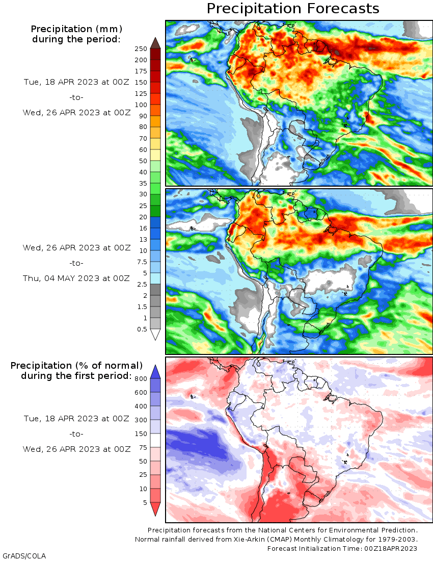
Brazil’s
summer monsoon is ending, but some rainfall is expected erratically over the next two weeks some of which will be from mid-latitude frontal systems and not due to the withdrawing monsoon -
Rainfall
will be greatest from Mato Grosso do Sul to Parana and Sao Paulo today and Wednesday in association with a cool front -
Net
drying is expected after that for a while -
Southwestern
Europe is still not likely to get much precipitation during the next ten days -
A
few showers will occur, but resulting precipitation will not be enough to counter evaporation -
Rain
is expected in most other areas periodically -
Europe
temperatures will continue near to above normal through the next ten days with southwestern areas driest and warmest -
CIS
precipitation in the coming week to ten days will be greatest from Belarus and the Baltic States through Ukraine to Russia’s Southern Region maintaining moisture abundance -
Temperatures
will be seasonable -
Spring
planting may be delayed at times, but winter crop development should be normal -
Western
and northern Russia precipitation will be light during the next ten days, but soil moisture will remain favorable -
India
precipitation over the next two weeks is expected to be typical of this time of year with periodic, pre-monsoonal, precipitation expected in the central, west, south and east while some unusually great rain falls from Uttarakhand to Jammu and Kashmir -
China
weather over the next two weeks will include; -
Frequent
rain in the Yangtze River Basin and areas south to the coast -
Some
rapeseed areas may become a little too wet -
Erratic
precipitation in the North China Plain, eastern Yellow River Basin and northeastern provinces through mid-week and then rain will develop in the Yellow River Basin late this week
-
Winter
wheat and early spring planting will benefit from northern China rainfall -
Xinjiang,
China will experience brief periods of light rain and cool air in the northeast through the next two weeks -
Cotton
and corn planting has begun, but mostly in western production areas where it has been warmest -
Northeastern
Xinjiang continues to experience bouts of cold and some additional frost and freezes are expected this week -
Western
Xinjiang will experience the best planting conditions, but temperatures will still be milder than usual -
Yunnan,
China is too dry and needs moisture for early season corn and rice as well as other crops -
The
province and neighboring areas are considered to be in a drought -
Dryness
will continue in the province cutting into rice and corn planting and production potential as well as some other crops -
Middle
East rainfall is expected from Turkey to Iran this week and will be great for winter and spring crops -
Cotton
and rice planting will benefit after the rain passes -
Winter
crops will fill favorably, but drier weather may soon be needed to protect grain quality -
Australia
precipitation will be minimal over the next week allowing some early season planting of canola, wheat and barley to begin -
Favorable
summer crop maturation and harvest progress is expected -
Rain
will develop in Victoria and neighboring areas late next week -
South
Africa precipitation should be restricted for a while favoring summer crop maturation and harvest progress -
North
Africa will continue too mostly dry along with Spain and Portugal over the next ten days -
Temperatures
will be warmer than usual -
Crop
stress will be expanding raising more concern over wheat and barley production as well as unirrigated spring and summer crops in Spain -
Mainland
areas of Southeast Asia are still in need of greater rain, although the situation is not critical
-
Poor
pre-monsoonal shower and thunderstorm activity has been occurring in many areas and improved rainfall will soon be needed -
This
is impacting some early season sugarcane, rice and coffee development as well as other crops -
Indonesia
and Malaysia weather has been lighter than usual due to the negative phase of Madden Julian Oscillation and this will continue through the coming week and possibly ten days -
Totally
dry weather is not expected, but rainfall may be lighter and more sporadic than usual -
Cotton
areas from Mali to Burkina Faso have not seen a normal start to the rainy season this year; rain is needed to support planting -
Other
west-central Africa coffee and cocoa production areas will receive routinely occurring showers and thunderstorms
-
East-central
Africa precipitation will be sufficient to support favorable coffee, cocoa and, rice and sugarcane development as well as other crops -
Mexico
remains in a drought, though eastern and far southern parts of the nation will get some periodic rain -
Central
Asia cotton and other crop planting is under way and advancing relatively well with adequate irrigation water and some timely rainfall expected -
Today’s
Southern Oscillation Index was -0.32 and it should move lower over the next several days.
Source:
World Weather, INC.
Bloomberg
Ag calendar
Tuesday,
April 18:
- China’s
2nd batch of March trade data, including agricultural imports - China’s
first quarter pork output and inventory levels - New
Zealand global dairy trade auction
Wednesday,
April 19:
- EIA
weekly US ethanol inventories, production, 10:30am - Brazil’s
Conab releases cane, sugar and ethanol output data - USDA
total milk production, 3pm - HOLIDAY:
Indonesia, Bangladesh
Thursday,
April 20:
- China’s
3rd batch of March trade data, including country breakdowns for commodities - Malaysia’s
April 1-20 palm oil export data - Cocoa
Association of Asia grinding data for first quarter - USDA
weekly net-export sales for corn, soybeans, wheat, cotton, pork and beef, 8:30am - Port
of Rouen data on French grain exports - USDA
red meat production, 3pm - HOLIDAY:
Indonesia
Friday,
April 21:
- ICE
Futures Europe weekly commitments of traders report - CFTC
commitments of traders weekly report on positions for various US futures and options, 3:30pm - FranceAgriMer’s
weekly crop condition report - US
cattle on feed, 3pm - HOLIDAY:
Brazil, Indonesia
Source:
Bloomberg and FI
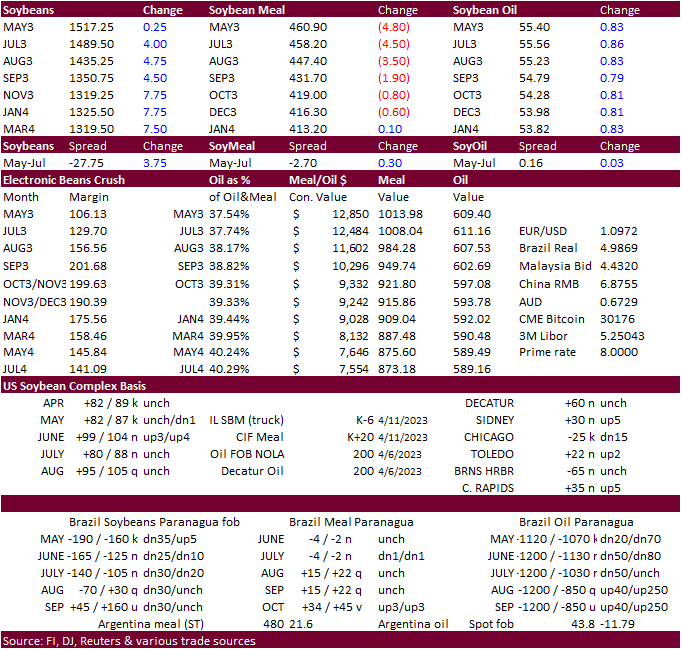
Soybean
and Corn Advisory
2022/23
Brazil Soybean Estimate Unchanged at 153.0 Million Tons
2022/23
Brazil Corn Estimate Unchanged at 123.0 Million Tons
2022/23
Argentina Soybean Estimate Lowered 2.0 mt to 24.0 Million
2022/23
Argentina Corn Estimate Lowered 1.0 mt to 35.0 Million
Chinese
GDP (Y/Y) Q1: 4.5% (exp 4.0%; prev 2.9%)
–
GDP SA (Q/Q) Q1: 2.2% (exp 2.0%; prev 0.0%) – GDP YTD (Y/Y) Q1: 4.5% (exp 4.0%; prev 3.0%)
Chinese
Industrial Production (Y/Y) Mar: 3.9% (exp 4.4%; prev 2.4%)
–
Industrial Production YTD (Y/Y) Mar: 3.0% (exp 3.5%; prev 2.4%)
Chinese
Retail Sales (Y/Y) Mar: 10.6% (exp 7.5%; prev 3.5%)
–
Retail Sales YTD (Y/Y) Mar: 5.8% (exp 3.7%; prev 3.5%)
Chinese
Fixed Assets Ex-Rural YTD (Y/Y) Mar: 5.1% (exp 5.7%; prev 5.5%)
Chinese
Property Sales YTD (Y/Y) Mar: -5.8% (exp -4.7%; prev -5.7%)
–
Residential Property Sales YTD (Y/Y) Mar: 7.1% (prev 3.5%)
Chinese
Surveyed Jobless Rate Mar: 5.3% (exp 5.5%; prev 5.6%)
US
Housing Starts Mar: 1420K (exp 1400K; prev 1450K)
Building
Permits Mar: 1413K (exp 1450K; prevR 1550K)
Housing
Starts (M/M) Mar: -0.8% (exp -3.5%; prev 9.8%)
Building
Permits (M/M) Mar: -8.8% (exp -6.5%; prevR 15.8%)
Canadian
CPI (Y/Y) Mar: 4.3% (exp 4.3%; prev 5.2%)
CPI
NSA (M/M) Mar: 0.5% (exp 0.5%; prev 0.4%)
CPI
BoC Core (Y/Y) Mar: 4.3% (exp 4.4%; prev 4.7%)
CPI
Core- Trim (Y/Y) Mar: 4.4% (exp 4.4%; prev 4.8%)
CPI
Core- Median (Y/Y) Mar: 4.6% (exp 4.5%; prev 4.9%)
106
Counterparties Take $2.239 Tln At Fed Reverse Repo Op. (prev $2.257 Tln, 102 Bids)
·
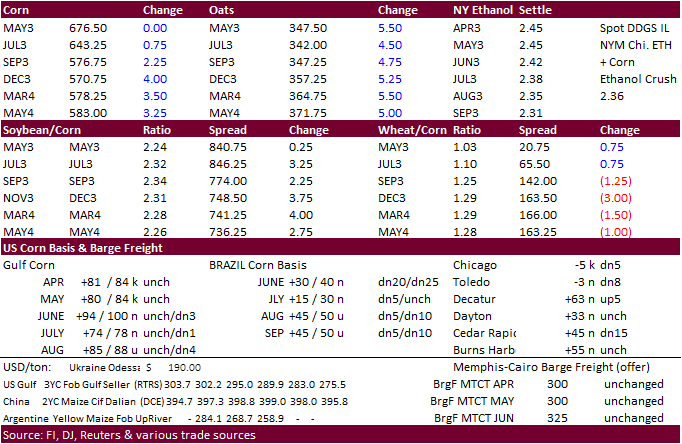
US corn futures ended higher after trading two-sided. Recall corn was strong Monday. A lower soybean meal market limited losses. Positive China economic data and ongoing Black Sea shipping concerns underpinned prices.
·
Funds bought 1,000 corn contracts.
·
Ideal conditions to plant corn and soybeans is when soil temperatures (3 inches) reach around 50 degrees Fahrenheit.
https://www.weather.gov/ncrfc/LMI_SoilTemperatureDepthMaps
·
China’s GDP was better than expected at 4.5 percent (4.0% expected).
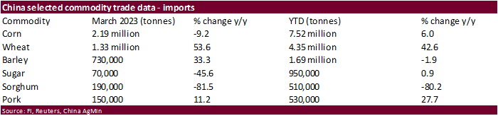
·
China imported 2.19 million tons of corn during the month of March, 6 percent above the same period year ago. YTD corn imports stand at 7.52 million tons, down 9.2% from year earlier.
·
China’s Q1 pork production increased 1.9% to 15.9 million tons. For Jan-Mar, that’s the highest since at lease 2018. Total meat output including pork, beef, mutton and poultry increased by 2.5% during the first quarter to 24.56
million tons. (Bloomberg)
·
The US Midwest will see precipitation this week, slowing fieldwork progress.
·
Anec sees Brazil corn exports reaching 186,552 tons in April, down from 207,000 tons seen previous week.
·
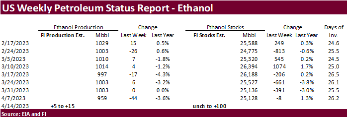
A Bloomberg poll looks for weekly US ethanol production to be up 9,000 thousand barrels to 968k (937-1003 range) from the previous week and stocks down 98,000 barrels to 25.030 million.
Export
developments.
·
None reported
Due
out Friday after the close
Updated
04/11/23
May
corn $6.10-$7.00
July
corn $5.75-$7.00
·
Funds bought 3,000 soybeans, sold 2,000 soybean oil and bought 2,000 soybean oil.
·
Despite higher cash oilmeal prices in Europe and China soybean meal futures appreciating 3.3%, CBOT soybean meal futures fell on demand destruction. Cash movement within Europe was slow. Some traders cited prices are too high.
US soybean meal basis was mostly unchanged across the Midwest.
·
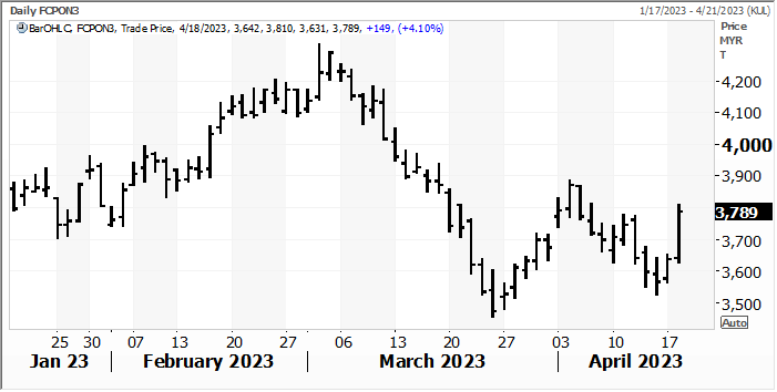
Soybean oil increased on strong global cash prices and spreading against soybean meal. July Malaysian palm oil surged little more than 4 percent, largest one day gain since December, over Indonesia supply concerns and Black Sea
shipping concerns. Indonesia palm stocks at the end of February fell 15 percent from January, reported by GAPKI last week.
·
Egypt seeks vegetable oils on Wednesday.
·
Anec sees Brazil soybean exports are seen reaching 15.15 million tons in April, up from 13.736 million estimated week earlier. Soybean meal exports are seen reaching 2.04 million tons in April, slightly below 2.09 million tons
seen previous week.
·
EU soybean imports so far this season reached 9.79 million tons by April 16 against 11.25 million previous season. EU rapeseed imports reached 6.37 million tons vs. 4.22 million year earlier. Soymeal imports were 12.54 million
tons, down from 13.08 million tons prior season.
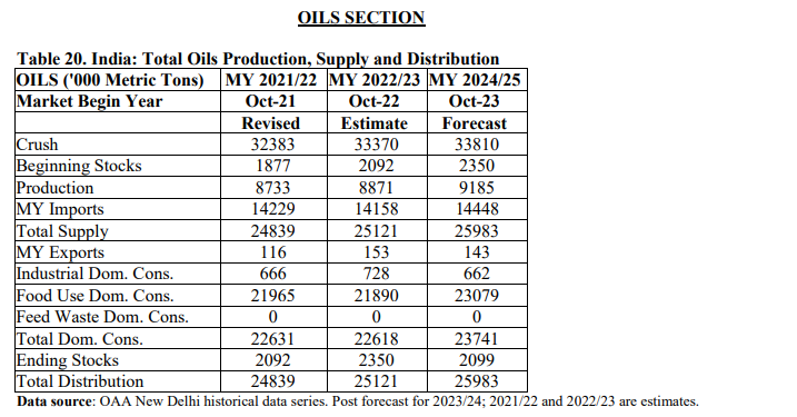
USDA
Attaché: India – Oilseeds Annual
Export
Developments
-
Egypt’s
GASC seeks an unspecified amount of international vegetable oils and small amount of domestic supplies of soybean oil and sunflower oil on April 19 for delivery between May 20 and June 15.
July
Malaysian palm oil
Updated
04/11/23
Soybeans
– May $14.50-$15.25, November $12.25-$15.00
Soybean
meal – May $420-$480, December $325-$500
Soybean
oil – May 53.00-57.00,
December 49-58
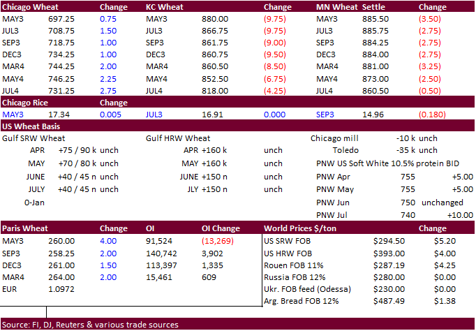
·
Black Sea uncertainty sent US wheat futures higher earlier, but prices eased on profit taking and prospects for large 2023 supplies. Chicago managed to rebound by afternoon trading and end higher. KC fell 6.50-8.50 cents. MN
was 2.50-3.50 cents lower. The USD was down 37 points as of 2:30 PM CT.
·
Poland reached an agreement with Ukraine over grain transit.
·
SovEcon upward revised their estimate of the Russian wheat crop for 2023 to 86.8 million tons from 85.3 million tons. The AgMin has an 80-85 million ton range. SovEcon lifted their Russian 2022-23 wheat export forecast by 0.4
million tons to 44.5 million tons.
·
Funds bought 1,000 Chicago wheat contracts.
·
May KC wheat hit sell stops after it traded through its 200-day moving average.
·
President Putin visited command posts in Ukraine (annex) as Russia increased assaults on Bakhmut.
·
Ukraine said grain shipments under the grain deal were delayed for a second day, but news agency RIA overnight reported ship inspections resumed. Then later in the morning a Ukraine official denied inspections have restarted.
·
Poland, Hungary and Slovakia recently banned imports of Ukrainian grain. Poland and Ukraine are in talks. Romania’s Social Democrat party supports a ban on Ukraine grain imports.
·
Ukrainian First Deputy Prime Minister said on Tuesday that the Black Sea grain deal is under threat of being halted.
·
The US weather forecast is wetter next week for the US wheat areas. Wet and cold conditions should slow spring wheat planting progress. Light snow will fall across the northern growing areas this week. Eastern KS and eastern NE
will see precipitation one time or another Wednesday through Friday.
·
China imported 1.33 million tons of wheat during the month of March, 43 percent above the same period year ago. YTD wheat imports stand at 4.35 million tons, up 53.6% from year earlier.
·
China sold 18,552 tons of wheat or 47 percent of what was offered back on April 12, at an average price of 2,578 yuan per ton.
·
EU soft wheat exports so far this season that started in July reached 24.37 million tons by April 16, versus 22.47 million a year earlier. EU barley exports were 5.05 million tons against 6.59 million a year ago.
Export
Developments.
·
Jordan bought 50,000 tons of wheat for LH Oct shipment at $303/ton c&f.
·
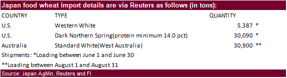
Japan seeks 66,377 tons of food wheat later this week.
·
Jordan seeks 120,000 tons of feed barley on April 19 for October through November 15 shipment.
·
China will auction off 40,000 tons of wheat on April 19.
Rice/Other
·
South Korea seeks 43,500 tons of rice on April 25 for July 1 and September 30 arrival.
Updated
04/11/23
KC
– May $8.25-9.00
MN
– May
$8.40-$9.00
#non-promo