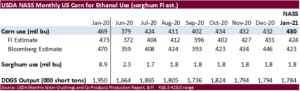
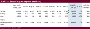
PDF Attached includes updated price ranges and FI graphs for NASS
CBOT agriculture markets were once again higher Sunday night into Monday morning and sold off during the day session. USD traded higher. WTI crude and other energy markets sold off on renewed Covid-19 variant concerns spreading throughout the world, just after the United States FDA over the weekend approved the use of the J&J single-dose Covid-19 vaccine shot. US equities shot up after yields paired gains.

World Weather Inc.
- Argentina received significant rain from southern Cordoba into southern Santa Fe and north-central and northwestern Buenos Aires overnight
- The storms were not predicted by any of the computer forecast models and an extreme amount of 4.65 inches occurred in southeastern Cordoba and 3.47 inches southwest of Marcos Juarez, Cordoba. Other rain totals varied from 0.20 to 1.00 inch
- The moisture will not last long with daily highs in the 90s Fahrenheit this week, but it was welcome rain in some important crop areas and will help to briefly slow the drying trend down
- Other showers and thunderstorms occurred Friday into Sunday morning from San Luis and La Pampa into Cordoba with rainfall of 0.20 to 1.00 inch and local totals to 1.87 inches.
- The remainder of Argentina was dry
- Excessive rains continued Sunday in areas south of the Ohio River into Arkansas and Tennessee culminating in some significant weekend totals
- Rainfall of 3.00 to 6.00 inches occurred most often in crop areas, but local totals of 6.00 to 8.30 inches occurred in the hill country of eastern Kentucky.
- Flooding occurred in many areas and saturated soil is now present from the Ohio River Basin southward through the central Delta
WORLD WEATHER AREAS OF INTEREST
- Argentina crop areas are facing another ten days of net drying
- Net drying will occur over the next ten days from Santa Fe and southern Corrientes as well as Uruguay into La Pampa and Buenos Aires
- Very little rainfall of significance and temperatures near to above average will occur daily throughout the period
- Subsoil moisture Sunday was still rated favorably while the topsoil was short to very short from parts of La Pampa and western Buenos Aires through most of Santa Fe and Entre Rios
- Chaco was still critically dry along with central and northwestern Formosa
- Weekend temperatures were in the 90s Fahrenheit and similar readings were expected this week with a few extremes over 100
- Crop stress will intensify this week as the ground continues to firm
- Subsoil moisture will begin decreasing in the driest areas and that will raise the potential for yield declines as early as the end of this week and especially next week if dryness prevails as advertised
- Rain potentials are advertised to increase after March 12 in portions of the nation – confidence is low, though
- Southern Brazil dryness will be eased this week with timely rain for the next ten days
- Mostly dry and warm weather occurred in southern Brazil Friday through this morning
- The region included most of Mato Grosso do Sul, southwestern Sao Paulo and areas west and south into Paraguay and western Rio Grande do Sul
- Topsoil moisture was rated marginally adequate to very short this morning
- Subsoil moisture was still rated adequately throughout the region keeping crops in good shape while the topsoil firmed
- Crop development and fieldwork advanced swiftly because of dying conditions
- Temperatures were in the 80s and lower 90s Fahrenheit Friday and Saturday afternoon
- Rain is expected periodically over the next ten days to prevent the region from experiencing moisture stress or any threat to production
- Total rain amounts will vary from 2.00 to more than 6.00 inches by mid-week next week with some potential for amounts over 8.00 inches in a few areas by Wednesday, March 10
- The recent dry weather was very good for advancing soybean maturation and harvest progress as well as the planting of Safrinha crops, but rain coming up will slow farming activity and raise some concern over the speed in which harvesting and planting advance
- Brazil rainfall during the weekend was greatest in northern and eastern Mato Grosso where totals of 1.00 to 3.00 inches occurred with local totals to 3.27 inches
- The rain delayed fieldwork in some areas raising concern over the condition of unharvested soybeans and further delaying some of the Safrinha corn planting
- Rain also fell significantly in northern and eastern Sao Paulo helping to ease long term dryness that had been threatening some grain and oilseed areas, but probably sugarcane and citrus crops a little more significantly
- Relief from dryness improved some crops and additional rain coming up soon will perpetuate the improving trend
- Scattered showers and thunderstorms elsewhere in Brazil were sporadic and light failing to counter evaporation in many areas
- Rainfall of 0.92 to 1.42 inches occurred in western and southern Minas Gerais while varying up to 0.50 inch elsewhere
- Net drying occurred in Goias, Bahia, northern and eastern Minas Gerais and southwestern Mato Grosso as well as most of southwestern Brazil as noted in the above bullets
- Most of Brazil will experience periods of rain through the next ten days to two weeks sufficing the needs of developing crops, but some of the moisture will interfere with crop maturation and harvest progress
- Net drying is expected in the northeast part of the nation from northern Minas Gerais to Bahia and in southern Rio Grande do Sul
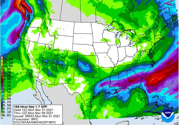
- U.S. rainfall will shift to the south today and Tuesday
- Areas from the lower Delta into South Carolina and Georgia will receive 0.50 to 2.50 inches of rain
- Areas to the north into the heavier rainfall areas of the weekend will be experiencing mostly dry conditions
- Most of the Mid-South, southeastern states and lower Midwest will be saturated with moisture through late this week – at least – despite mid-week drying
- One more storm system is expected this weekend will produce additional rain of significance and perpetuate the wet bias
- Net drying will occur in these areas next week and that should start a more prolonged period of net drying
- U.S. central and southwestern Plains will receive rain Thursday into Friday as a small weather system comes into the region from the southwestern states and dissipates
- Moisture totals of 0.20 to 0.75 inch with a few totals over 1.00 inch are possible
- The greatest rain is advertised from eastern Colorado into central Oklahoma
- This event may weaken in future model runs
- Limited moisture is expected in West Texas, although it will not be dry
- Localized areas of improved topsoil moisture will occur as a result of this week’s storm – mostly in southwestern hard red winter wheat areas
- U.S. Midwest weather will be void of significant storm systems for a while in the coming week, but a more active weather pattern is expected in the second week of the forecast bringing moisture to many areas in Midwest and portions of the Great Plains
- Moisture totals in the high Plains of hard red winter wheat country will remain light and somewhat sporadic leaving need for more moisture
- Other wheat areas will get some welcome precipitation as will the northeastern Plains and upper Midwest
- U.S. temperatures this week will be warmer than usual in the central and northern Plains, cooler than usual in the northeastern and middle Atlantic Coast States and in few Pacific Northwest locations
- Next week’s temperatures will trend a little cooler in the western states and a little warmer in the Midwest – at least until the March 14-16 storm passes and then it will trend a little cooler again
- U.S. weather trends in the next ten days….
- Net drying in West Texas – leaving need for greater precipitation
- Restricted rain in South Texas and the Texas Coastal Bend – leaving these areas in need of significant moisture
- Northwestern U.S. Plains precipitation will be limited leaving some dryness in place, despite a little moisture
- Southwestern desert region will need more moisture and what showers do occur will be limited leaving the ground drier biased
- Erratic precipitation will occur in the Pacific Northwest, California’s central Valleys and the Rocky Mountain region
- The Delta and southeastern states will remain or become quite wet this week and then begin drying down this weekend into next week
- Midwest soil moisture will be abundant in the Ohio River Valley and a little drier to the northwest until next week’s bigger storm systems evolve at which time sufficient relief from recent drying is expected
- NOAA’s updated 30-day outlook for the U.S. in March showed very little change from the previous outlook
- Cooler than usual temperatures were expanded southward from the Pacific Northwest through the northern and western Great Basin and much of California
- Warmer-than-usual weather is expected for most areas east of the Rocky Mountain States
- Precipitation is still advertised above normal in the northern Delta, Tennessee River Basin and central and eastern Midwest
- Precipitation is still advertised below normal in the central and southern Plains, the central and southern Rocky Mountain region, the southwestern desert region, in Florida and in the central Gulf of Mexico coastal region; including, southern Georgia and all of Texas
- Canada’s central and southwestern Prairies will remain drier than usual through the next ten days while light precipitation occurs elsewhere
- Temperatures will be near to above average
- Southeast Canada will experience a seasonable mix of precipitation and sunshine with temperatures a little cooler than usual
- North Africa rainfall will improve this week with many areas from northern Morocco through northern Tunisia getting rain at one time or another lifting topsoil moisture for future crop development
- Weekend rainfall was sporadic and mostly light in Morocco
- Temperatures were mild
- Winter crops are semi-dormant
- Ivory Coast will experience another boost in rainfall for a while this week favoring coffee and cocoa flowering
- Precipitation in Ghana and areas east through Nigeria to Cameroon will be mostly confined to coastal areas
- Weekend precipitation was mostly near the coast in the majority of crop areas, but satellite imagery did suggest a few showers and thunderstorms in a part of Ivory Coast coffee and cocoa country
- East-central Africa rainfall will continue greatest in Tanzania this week and probably next week, as well
- A more erratic and light precipitation pattern is expected elsewhere with net drying in Ethiopia, northern Uganda and in a few southwestern Kenya locations
- South Africa will experience an erratic rainfall pattern through the next two weeks with temperatures mostly in a seasonable range with a slight warmer bias in the west
- Weekend rainfall was scattered in northern and a few southeastern crop areas where amounts varied from 0.05 to 0.50 inch most often and a few local totals as great as 2.60 inches in eastern Limpopo and 1.58 inches in south-central North West
- Net drying occurred in many other areas
- Temperatures were seasonable in the west and a little milder than usual in the east
- Summer crop conditions will remain favorably rated, although there will be a growing need for showers by mid-March
- India experienced net drying during the weekend, despite a few showers producing up to 0.20 inch of moisture in northern crop areas
- Himachal Pradesh and Jammu and Kashmir were much wetter
- Very little rainfall is expected over the next week to ten days and temperatures will be seasonably warm
- Some mild crop stress is expected resulting in some minor yield loss
- Rain is needed to support the best potential yields before filling ends during March
- China weekend weather was plenty moist in the Yangtze River Basin and areas south to the southern coast where 0.15 to 0.60 inch was common
- Greater rainfall occurred in the lower Yangtze River Valley and in Zhejiang, Fujian and northeastern parts of Guangxi where 0.60 to nearly 2.00 inches resulted
- Rain also fell significantly in the Yellow River Basin and North China Plain where 1.00 to 2.10 inches of rain was reported saturating the soil after similar rainfall impacted the region late last week.
- A little rain and snow also fell in Inner Mongolia and portions of Northern China’s key agricultural areas where moisture totals varied up to 0.35 inch
- Temperatures were cool in the southeast and mild to warm in the north
- China weather this week will include seasonable temperatures and near to above average precipitation
- The greatest precipitation relative to normal will be in the Yangtze River Basin and areas to the south
- Rainfall near and south of the Yangtze River will vary from 0.60 to 2.00 inches with a few local totals over 4.00 inches in the upper Yangtze River Valley
- Australia weekend precipitation was greatest in northeastern New South Wales where 0.62 to nearly 4.00 inches resulted
- Most of this was in the Darling Downs region
- Other crop areas to the west in both New South Wales and Queensland was not enough to counter evaporation with highest afternoon temperatures in the 90s to 100 degrees Fahrenheit
- Significant rain also fell in the Cape York Peninsula and southward to the central Pacific Coast where 1.50 to more than 4.00 inches resulted
- Australia weather this week is expected to bring on restricted amounts of precipitation in key sorghum, cotton and other summer crop areas while temperatures are seasonable
- Mexico drought conditions are still prevailing, although the impact on winter crops is low due to irrigation
- Water supply is low in some areas and a notable improvement in rainfall is needed, but not very likely
- Dryland winter crops are stressed and will yield poorly
- Freeze damage is common in northern parts of the nation due to a couple of cold surges this winter
- Rain in the coming week will be mostly confined to the east coast and temperatures will be seasonable with a slight warmer bias in the driest areas
- Central America precipitation will continue greatest along the Caribbean Coast and in Guatemala while the Pacific Coast is relatively dry
- Southeast Asia rainfall will occur relatively normally over the next two weeks
- Mainland areas will experience few showers periodically in the next week to ten days
- The resulting rainfall will be sporadic and light with net drying probably continuing for a while
- Philippines rainfall will be scattered and light until mid-week next week when a boost in precipitation is expected
- Indonesia and Malaysia weather during the next two weeks will bring rain to most crop areas maintaining a very good outlook for crop development
- Sumatra, Peninsular Malaysia and western parts of Borneo have been drying out recently and greater rain is needed especially in Peninsular Malaysia
- New Zealand weather over the next ten days will include a boost in rainfall and some cooler than usual temperatures
- Southern Oscillation Index has been falling and was at +10.48 this morning. The index is expected to continue to fall notably over the next several days
- Warming in Europe and the western CIS melted snow during the weekend
- Snow-free conditions are present today in Russia’s Southern Region, much of Ukraine and in many areas across Europe to the west of Ukraine and eastern Poland
- Warming during the weekend presented no threatening cold to any winter crop region
- Europe weather will be tranquil this week with only brief periods of light precipitation and temperatures close to normal
- A boost in precipitation is expected next week
- Western CIS temperatures will be seasonable with a slight warmer bias this week and some additional melting snow is expected
- Precipitation will remain periodic keeping the region plenty moist in snow free areas and some significant runoff is expected in areas warm enough for melting snow
Source: World Weather Inc.

Source: World Weather Inc.
USDA inspections versus Reuters trade range
Wheat 272,820 versus 300000-500000 range
Corn 1,636,876 versus 1150000-1750000 range
Soybeans 879,582 versus 400000-800000 range
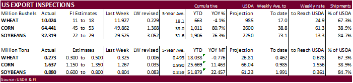
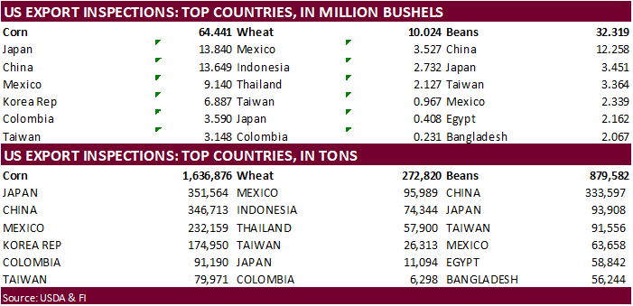
GRAINS INSPECTED AND/OR WEIGHED FOR EXPORT
REPORTED IN WEEK ENDING FEB 25, 2021