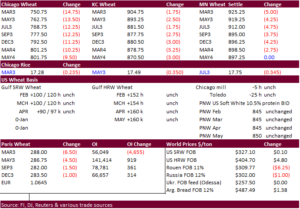
PDF Attached. Funds were NA at the time this was sent.
After a one-day holiday for the US, CBOT soybeans surged on SA weather concerns. Several traders cited Argentina will not see enough rain this week. Argentina’s southern and parts of central growing areas saw frost over the weekend. Soybean meal ended higher. Soybean oil reversed to trade and end higher. Corn followed soybean higher and US wheat fell on fund selling. Several import tenders developed since Friday, including Egypt and Turkey in for wheat. Egypt is also in for vegetable oils. USD was higher and WTI ended lower. US equities were on the defensive.
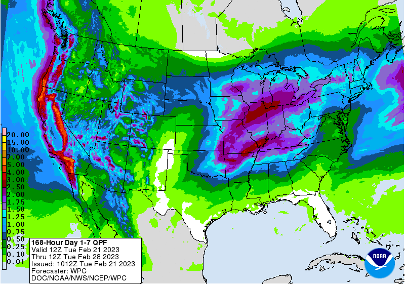
Not much in the way of changes to the North and South American weather forecasts from that of late last week. Argentina’s outlook did turn slightly unfavorable. Over the weekend, Argentina’s Cordoba, parts of La Pampa, San Luis and northwestern BA saw frosts that impacted corn and soybeans. It will take some time to figure out the extent of the damage. Light rain will favor Cordoba, Santa Fe, Entre Rios, southeast Buenos Aires Wednesday. Brazil’s Mato Grosso, Goias, south Minas, Sao Paulo, MGDS, Parana, and Santa Catarina through Saturday. The US will see multiple weather warnings/watches this week coast to coast. The upper US ECB will see a winter storm through Thursday. Snow is expected to fall across north NE, north CO Wed, rain in east KS, east OK, east TX, and then rain for east OK Friday through Saturday.
MOST IMPORTANT WEATHER FOR THE DAY
- Frost occurred in portions of Argentina Saturday morning after similar conditions occurred briefly Friday in southwestern areas
- Several locations in east-central San Luis, west-central and northwestern Cordoba fell near and below freezing resulting in some significant frost.
- Crop damage was likely most significant in these areas and the impact was greatest on soybeans than corn.
- A killing freezing was not suspected, but leaf damage may have been great enough to impact the more immature crops and their production potential
- Soft frost occurred in many other areas, but World Weather, Inc. does not believe the majority of summer crop areas were cold enough for a long enough period of time to experience permanent damage
- Most officially reported low temperatures were 35 to 45 degrees Fahrenheit or +2 to +7C in San Luis, Cordoba, southern Santiago del Estero, southern Santa Fe, Buenos Aires and La Pampa
- Colder readings were suspected in outlying areas especially in lower pockets, but official lows were no colder than 35 or +2C except in east-central San Luis and west-central into northwestern Cordoba where extremes near and slightly below freezing were noted
- Argentina precipitation Friday through this morning was not enough to counter evaporation, despite cooler temperatures
- Up to 0.20 inch of moisture fell in Buenos Aires except near the southeast coast where as much as 0.45 inch resulted. Rainfall to 0.45 inch also occurred in northwestern Santiago del Estero
- More than 75% of the nation was dry
- Argentina top and subsoil moisture was rated short to very short Friday except in southern Cordoba, east-central San Luis and in central and southeastern Buenos Aires where it was rated adequately
- Salta and some immediate neighboring areas also had adequate soil moisture
- Crop stress was high in much of the nation, but cooler temperatures during the weekend helped to reduce some of that stress
- Highest weekend temperatures were mostly in the 70s and lower 80s Fahrenheit
- Southern Argentina precipitation will be restricted over the next ten days, although totally dry weather is not expected
- Northern Argentina will receive rain late this week and into the weekend resulting in a general boost in soil moisture in northern cotton areas as well as in some of the dry bean, sugarcane and citrus region in far northwestern Argentina
- The moisture will be welcome and should lead to some crop improvement; however, relief from drought in other parts of Argentina is not very likely
- Rain increased in Mato Grosso, Goias and eastern Mato Grosso do Sul during the weekend as expected
- Rainfall varied from 1.00 to 3.50 inches in a part of the region while other areas nearby failed to get much more than 0.40 inch
- Some of the drier areas were able to proceed with fieldwork while the wetter areas experienced more delay to farming activity
- Net drying occurred in far southern Brazil during the weekend and many areas in the northeast continued to dry out as well
- Temperatures were seasonable in the drier areas
- No extreme heat was noted, although a few middle 90-degree highs occurred in northern Minas Gerais and Rio de Janeiro
- Brazil soil moisture Friday was rated adequate to excessively wet from Mato Grosso to Parana, Sao Paulo and southern Minas Gerais while adequate in the topsoil in Rio Grande do Sul and marginally adequate to very short in the subsoil
- Topsoil conditions in Bahia, northern Minas Gerais and neighboring areas are drying out
- Brazil weather is expected to change very little over the next two weeks
- Rio Grande do Sul precipitation should be limited through Wednesday and then scattered showers will develop Thursday into Saturday offering temporary relief
- Rainfall of 0.50 to 1.50 inches will result in northern soybean areas in Rio Grande do Sul while southern rice and corn areas get no more than 0.75 inch
- Drier weather will occur for several more days following the late week rain event returning or continuing crop moisture stress
- Northeastern Brazil crop areas; including central and eastern Bahia, northeastern Minas Gerais and Espirito Santo will vary from 0.20 to 0.80 inch with a few amounts to 2.00 inches along the coast during the next ten days
- Rain in most other areas of Brazil during the next ten days will range from 2.00 to 4.00 inches with a few local totals over 5.00 inches
- Wettest in Mato Grosso do Sul, Sao Paulo, northern Parana and southern Minas Gerais
- Local flooding is possible, although most of the rain will be spread out over multiple days limiting the potential for serious flooding
- Delays to soybean harvesting and Safrinha corn planting will continue
- Brazil’s bottom line remains of concern for Safrinha corn and cotton which are being planted later than desired
- An early end to the rainy season (which is not expected) could harm production
- A normal end to the rainy season could lead to some crop moisture stress during reproduction for late planted corn and cotton
- World Weather, Inc. believes the monsoon will end normally this year – sometime in April
- Rio Grande do Sul crop yields in the central and south are likely to be notably low while northern crops are expected to perform well enough to minimize some of the lower production
- Delays to harvesting of soybeans in the heart of Brazil may result in some quality decline for a few of the wettest areas, but no change to the mammoth crop is likely
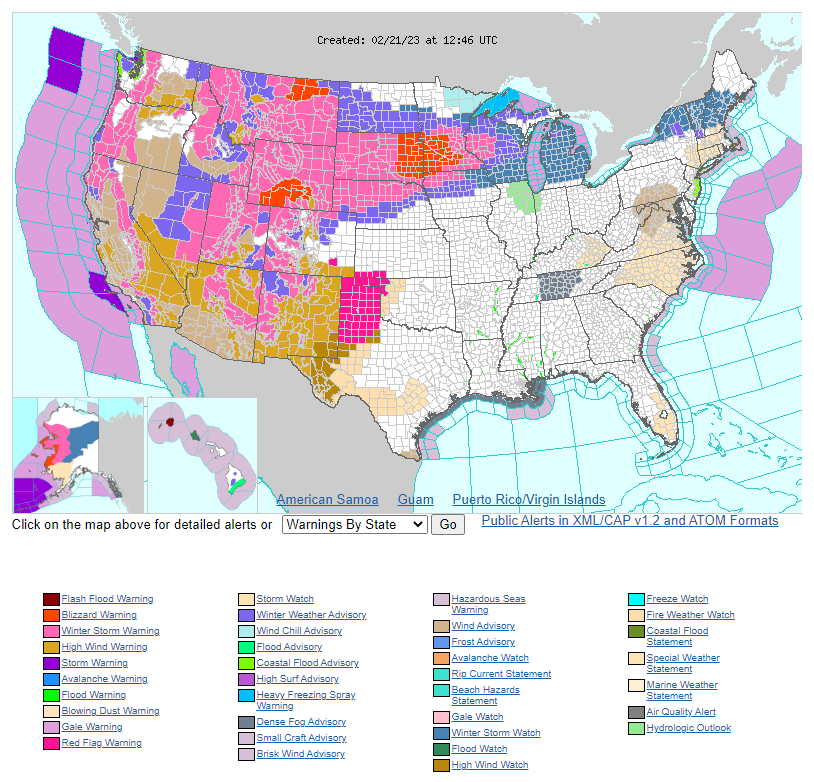
- North America temperatures will be cold in Canada’s Prairies and most of the western and north-central parts of the contiguous United States over the next two weeks
- Temperatures will be warmer than usual from the southern U.S. Plains through the Delta, Tennessee River Basin and southeastern states to the middle Atlantic Coast States
- North America precipitation over the next ten days to two weeks will disfavor precipitation in the southeastern corner of nation from the Gulf of Mexico Coast States to the southern Atlantic Coast States
- Totally dry weather is not expected, but warm temperatures and limited rainfall will lead to net drying
- Canada’s Prairies will be drier than usual during the next two weeks except in western and southern Alberta and far southwestern Saskatchewan where abundant snow will fall through mid-week this week
- The snow will help put some protection on the ground after weeks of snow-free conditions in the southwestern (drought-stricken) Prairies
- Snow will fall in waves from Montana and parts of Wyoming through southern North Dakota, South Dakota and parts of Nebraska to the Great Lakes region during the next ten days
- Some substantial accumulation is expected from South Dakota to Michigan and neighboring areas where travel delays are likely and livestock stress is expected
- Some areas may receive 8-20 inches of snow with the potential for a few areas to get more than 24 inches over the ten days
- U.S. west-central and southwestern Plains precipitation will be restricted during the next week, but there is some potential for light precipitation early next week and again in the first couple of days in March
- Confidence is low, but these potential rain events will be very important for hard red winter wheat and for grain and cotton areas in the southwestern Plains
- Winterkill is not likely to be much of a threat in the northern or central U.S. Plains this week due to snow cover being present in all areas that will be vulnerable to the coldest temperatures
- U.S. Delta, lower Midwest and Tennessee River Basin will experience frequent precipitation over the next ten days to two weeks
- Soil conditions should remain saturated or nearly saturated
- Eastern Canada crop areas will receive frequent rain and snowfall during the next two weeks maintaining moisture abundance
- Europe precipitation during the weekend was greatest from the North and Baltic Sea regions through the Baltic Plain to Belarus, and Ukraine with some moisture in northwestern Romania
- Most other areas were dry
- Europe precipitation will slowly increase over the next two weeks, although this first week of the outlook will continue to have erratic precipitation of light intensity
- The second week outlook may be a little wetter
- Soil moisture across the continent is lighter than usual for this time of year
- CIS snow cover increased during the weekend from the Baltic States, Belarus and Ukraine into Russia’s Southern Region adding protection to winter crops against cooler temperatures
- Western CIS temperatures will be cooler than usual this workweek, but there will be no crop damage because of good snow cover throughout the region
- Europe temperatures will be warm over the next ten days to two weeks and most of Asia’s temperatures will be warmer than usual outside of the cool western Russia and neighboring areas briefly this workweek
- North Africa precipitation will increase in Morocco and northern Algeria during the coming week to ten days, but Tunisia will remain drier than usual
- Southwestern Morocco will be wettest, but that region is 100% irrigated and no planting occurred this year because of a multi-year drought that had depleted water supply
- Very little change in production potential is expected, although northern Morocco and northern Algeria will benefit from the moisture expected late this week into next week
- India is still advertised to receive a restricted amount of rain during the next two weeks resulting in crop moisture stress during reproduction
- Beneficial moisture will occur from Uttarakhand to Jammu and Kashmir which is a minor winter crop production region
- Concern over pulse, winter grain and winter oilseed production potential will continue because of limited precipitation and near to above normal temperatures
- Southeast Asia weather will be mostly good over the next two weeks with all areas getting rain
- Philippines rainfall was heavy during the weekend from eastern Mindanao to southeastern Luzon Island where some flooding was suspected
- Local rain totals varied from 2.50 to more than 9.00 inches
- One location reported more than 12.00 inches of rain in southeastern Luzon
- China weather will continue mostly good for its winter crops during the next two weeks
- Rain will be greatest from Sichuan and immediate neighboring areas southwest into Yunnan and neighboring areas
- Eastern Australia summer crop areas will continue to experience an erratic rainfall pattern that will not provide much moisture for dryland crops
- There is some potential for improved rainfall next week in northeastern New South Wales, but many of the dryland crop areas of Queensland and western New South Wales that are hurting for moisture will continue to hurt for moisture
- South Africa rainfall will be wettest in northeaster parts of the nation during the coming week while net drying occurs in many other areas
- Summer crop conditions are still rated well in much of the nation, though some greater rain is needed in the west
- Tropical Cyclone Freddy will pass to the north of Mauritius and Reunion Islands early this week before moving across southern Madagascar and eventually into southern Mozambique
- Some heavy rain and flooding is expected along with some wind damage. The impact on agriculture should be low
- Middle East precipitation is expected to be erratic over the next couple of weeks raising some need for greater precipitation prior to cotton and rice planting season.
- Wheat conditions are rated favorably, but would benefit from additional rain
- Turkey is wettest while Syria, Iraq and Lebanon need greater rainfall
- Eastern Africa precipitation will be greatest in Tanzania during the next ten days which is not unusual at this time of year
- Some rain is expected to develop in Ethiopia, Uganda and Kenya over time, although amounts should be light
- West Africa rainfall is expected to slowly increase over the coming week bringing some welcome rain to coffee, cocoa, sugarcane and rice production areas
- Flowering may begin in some coffee and cocoa areas if the rain is as great as advertised by the GFS model
- Monday’s Southern Oscillation Index was +13.06 and it will move lower over the next several days.
Source: World Weather and FI
Tuesday, Feb. 21:
- National Farmers’ Union Conference, Birmingham, UK, day 1
- Grain Forum Dubai 2023, day 1
- New Zealand global dairy trade auction
- USDA export inspections – corn, soybeans, wheat, 11am
- EU weekly grain, oilseed import and export data
- HOLIDAY: Argentina, Bangladesh
Wednesday, Feb. 22:
- Suspended until February 24 – CFTC commitments of traders
- National Farmers’ Union Conference, Birmingham, day 2
- Grain Forum Dubai 2023, day 2
- USDA total milk production, 3pm
- US poultry slaughter, 3pm
Thursday, Feb. 23:
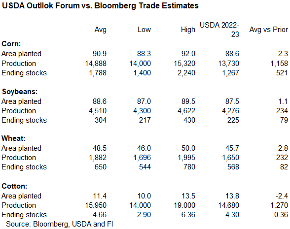
- USDA’s acreage outlook for corn, soy, wheat and cotton
- The USDA’s Agricultural Outlook Forum, Arlington, day 1
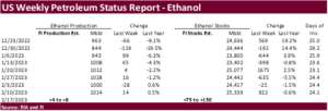
- EIA weekly US ethanol inventories, production, 10:30am
- Port of Rouen data on French grain exports
- Sugar production and cane crush data from Brazil’s Unica (tentative)
- USDA red meat production, 3pm
- HOLIDAY: Russia
Friday, Feb. 24:
- USDA’s full outlook for corn, soy, wheat and cotton
- The USDA’s Agricultural Outlook Forum, Arlington, day 2
- USDA weekly net-export sales for corn, soybeans, wheat, cotton, pork and beef, 8:30am
- ICE Futures Europe weekly commitments of traders report
- CFTC commitments of traders weekly report on positions for various US futures and options, 3:30pm
- FranceAgriMer’s weekly crop conditions reports
- US cattle on feed, 3pm
- US cold storage data for beef, pork and poultry, 3pm

Soybean and Corn Advisory
2022/23 Argentina Soybean Estimate Lowered 2.0 mt to 34.0 Million
2022/23 Brazil Soybean Estimate Unchanged at 151.0 Million Tons
2022/23 Argentina Corn Estimate Unchanged at 43.0 Million Tons
2022/23 Brazil Corn Estimate Unchanged at 123.0 Million Tons
USDA inspections versus Reuters trade range
Wheat 373,429 versus 300000-525000 range
Corn 622,841 versus 500000-750000 range
Soybeans 1,578,066 versus 1000000-1965000 range
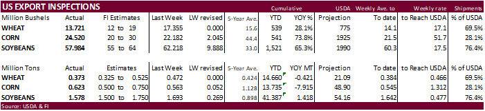
GRAINS INSPECTED AND/OR WEIGHED FOR EXPORT
REPORTED IN WEEK ENDING FEB 16, 2023