PDF Attached
Sharply
lower trade from follow through selling. Thursday
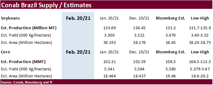
morning Conab is due out with updated Brazil supply estimates.
![]()
LITTLE
CHANGE AROUND THE WORLD OVERNIGHT
- Argentina
weather Tuesday - Rain
fell mostly in the north with northeastern Santa Fe and northwestern Santiago del Estero into Salta wettest
- Rainfall
ranged from 0.20 to 0.62 inch most often with local totals to 1.38 inches in northeastern Santa Fe and to 2.48 inches in northwestern Santiago del Estero - Thunderstorms
in the city of Buenos Aires overnight produced up to 1.73 inches of rain - Most
other crop areas in the nation were dry with afternoon temperatures in the 70s in many key crop areas in the west and south which helped conserve soil moisture through slower drying rates - High
temperatures in the northeast were still in the 80s and lower 90s Fahrenheit - Argentina
will continue to experience restricted rainfall from La Pampa and western Buenos Aires into western Santa Fe and eastern Cordoba over the next ten days - Any
showers that occur (and there will be some) will be brief and light failing to counter evaporation, but will they will help slow the drying trend - Rain
will be a little more significant periodically in eastern Buenos Aires, Entre Rios and northern parts of Argentina; including Santiago del Estero and a few western Cordoba locations - Temperatures
will be seasonable - Most
crops in the nation will remain in favorable condition for the coming week due to either favorable subsoil moisture or due to timely rainfall. Some drying is expected and a rise in crop stress is probable for the drier areas noted above, but critically dry
conditions are not expected in this first week of the outlook. World Weather, Inc. still believes late February rainfall will increase in time to maintain a favorable – not ideal – outlook for summer crop development.
- Brazil
weather Tuesday was good for soybean and first season corn maturation and harvest progress - Rain
was limited to northern and eastern Minas Gerais and a few neighboring areas and along the southwestern Bahia/southeastern Tocantins border
- Rainfall
in these areas varied from .30 inch to 1.00 inch with local totals to 1.42 inches except in the Bahia/Tocantins region where up to 2.92 inches resulted - Limited
rainfall elsewhere in Brazil led to aggressive fieldwork and extended the favorable conditions beyond five days allowing more aggressive fieldwork to take place - High
temperatures were in the 90s and near 100 Fahrenheit in Mato Grosso which helped to accelerate drying and perpetuate fieldwork - Highs
in the 80s and lower 90s occurred in many other areas with some 70s in eastern Minas Gerais and parts of both Espirito Santo and Rio de Janeiro - Brazil
weather is still expected to be favorably mixed over the next two weeks with alternating periods of rain and sunshine supporting crop maturation and fieldwork as well as supporting normal crop development - Today
will be another (day 6) drier biased day in western and southern Brazil favoring aggressive crop maturation, harvesting and planting - Showers
will slowly increase Thursday through the weekend in western and southern Brazil slowing some of the field progress, but harvesting and planting will continue to advance around the precipitation - Greater
rain is expected more often next week and that is when the harvest pace will slow the most, but good progress will have been made by that time and some of the concern over harvest delays may have waned.
- Rain
may fall a little more often than desired in several areas, but the pattern will not be anomalously wet enough to induce a serious crisis in fieldwork - Some
areas will need drier weather while others will experience sufficient drying time to support favorable advancements in the planting of Safrinha crops and the harvest of soybeans - Much
needed rain started falling in southern China Tuesday and it will continue today impacting areas from Guangxi and Guangdong to Fujian and Zhejiang - These
provinces were quite dry and considered to be in various stages of drought, according to the China Meteorological Department - Rainfall
was much greater than expected with 3.00 to more than 4.00 inches common in Guangxi and immediate neighboring areas - One
location in Guangxi reported 7.48 inches resulting in flooding - Rainfall
farther to the north into eastern Guizhou, central and southern Hunan, western Guangdong and southern Jiangxi ranged from 2.00 to 4.00 inches - The
precipitation today will shift east into the Zhejiang, Fujian and eastern Guangdong with slightly less intensive rain expected - Significant
relief to drought conditions will have resulted in many areas ending concern over chronic dryness – for now - China
temperatures have been warmer than usual in recent days, but did trend a little cooler Monday - The
warmth has stimulated a little rapeseed development in the south, but no aggressive plant development is expected for a while - Temperatures
will remain a little warmer than usual, but still cool enough to keep development in check for a while - No
threatening cold will occur in the nation’s wheat or rapeseed areas for the next ten days, although the northeast will trend colder next week - Northwestern
Ukraine, southeastern Belarus and west-central Russia will experience heavy snow and blizzard conditions tonight through the weekend with 10-22 inches of snow from a single storm - Livestock
stress and travel delays are likely - Bitter
cold will follow the event, but winter grains will be adequately protected from the cold - Snow
will continue to fall over many areas in eastern Europe and the western CIS during the next ten days keeping snow cover present to protect most winter crops from damaging cold - Flood
potentials remain high in western Europe due to saturated soil and frequent ongoing bouts of precipitation - No
large storms are expected in the coming ten days reducing the fear of flooding for now - Temperatures
will be colder than usual in much of Europe outside of Spain for a while - No
winterkill is expected for small grains or rapeseed because of significant snow cover in the coldest areas - Russia’s
Southern region has seen snow cover expand over most of the region, but a temporary bout of warming today into Friday may melt some of that snow - Cooling
next week will bring back snow just in time to protect winter crops from bitter cold air - North
Africa will continue to experience erratic rainfall - Dryness
remains a concern in southwestern Morocco and northwestern Algeria with favorable conditions in most other areas - Winter
crops are semi-dormant and do not have much need for precipitation now, but greater precipitation will be needed in a few weeks as spring growth begins - India
may get some welcome precipitation in the central and south parts of the nation Feb. 17-23, but the coming seven days will remain mostly dry - Any
precipitation would be welcome for winter grain, oilseeds and pulse crops - Sugarcane
and rice would also benefit from the precipitation - Eastern
Australia weather still looks highly favorable in New South Wales where a mix of rain and sunshine is supporting many crops especially the irrigated cotton and sorghum - Little
change in the current trend is expected for the next two weeks - Queensland,
Australia will receive some important rainfall as scattered showers and thunderstorms occur during the next two weeks - Portions
of the state’s grain and cotton areas will not get enough rain to seriously bolster soil moisture, but other areas will see a good mix of weather - Irrigated
crops are in the best condition and will remain that way - South
Africa weather will include net drying in the central and eastern production areas for a while over the next ten days - Rainfall
Tuesday was quite limited with a few showers and thunderstorms in North West and in a few areas from southern Free State into western Natal - Natal
and some neighboring areas will be wettest Friday through the weekend with some heavy rainfall and flooding possible near the coast - Temperatures
will be seasonable with a warm bias in the west - Indonesia,
Malaysia and Philippines weather is expected to be varied over the next ten days with periods of rain expected – most of which will be light intensity - Some
locally moderate rain will be possible - Heavy
rain may impact a part of the east-central and southeastern Philippines in the February 17-23 period
- Vietnam,
Laos and eastern and southern Thailand received rain Tuesday after some had already occurred in northern areas Monday - The
moisture was welcome for winter crops, but it may have induced some coffee flowering in the north of Vietnam - The
return of drier today weather will be equally welcome since seasonal rainfall does not usually begin in the mainland areas of Southeast Asia until March
- Bitter
cold will continue in North America through the weekend with some moderation in temperatures Sunday into early next week - Some
of the coldest air will push through the central Plains and a part of the U.S. Midwest this weekend and early next week before retreating into eastern Canada - Waves
of snow will continue while the bitter cold is in place and that snow will be extremely important for winter wheat in the Midwest and central Plains - No
winterkill is expected in soft wheat areas in the Midwest or in hard red winter wheat production areas - Snow
free areas in the northern Plains and a part of Saskatchewan might have induced winterkill for some minor wheat production areas in recent days and the losses are not expected to expand much further - These
are minor wheat production areas relative to the nation’s entire crop, although a few counties in South Dakota may lose some of their crop and that area does produce more winter wheat than North Dakota
- Waves
of snow will impact the central and southwestern Plains through the weekend
- Friday
through Monday will generate two well organized bouts of snow - Total
accumulations will vary from 5 to 12 inches and there will be some potential for more than 12 inches in some locations, but more detail over the potential snowfall will come as we get closer to the events - Moisture
content in the snow will be low because of the cold temperatures, but it will still be helpful in moistening the topsoil as it melts later this month
- Livestock
stress will remain very high in the north and increase in the south because of colder temperatures and the snow - Transportation
delays are also expected - A
storm system late this weekend and early next week in the Delta will move through the lower and eastern Midwest to the northeastern states during the first half of next week producing impressive rain, freezing rain, sleet and snow - Travel
delays and areas of local flooding may result along with some power outages and livestock issues - River
icing on the upper Mississippi, upper and middle Missouri and Illinois Rivers will continue over the next several days slowing or shutting down barge traffic for a while - U.S.
southeastern states will experience waves of rain and some snow, freezing rain and sleet over the next ten days maintaining wet field conditions and inducing some travel delay while stressing livestock - U.S.
livestock stress will continue significant across the northern and central Plains and upper Midwest through the weekend and into early next week with some increase in animal stress in the southwestern Plains for a little while this weekend as well - Milk
production could slip lower and animal weight gains may be slow - There
will be some risk of animal death or injury because of the bitter cold, snow and extreme wind chills - U.S.
northwestern states will see waves of snow and rain from mid-week this week through next week, but the precipitation will be greatest along the coast and in the mountains - Drought
status is not likely to change much in the interior western states - U.S.
northern Plains drought will not be changed over the next week to ten days, despite some bouts of light snow from Montana to South Dakota - The
same is true for Canada’s eastern and southern Prairies drought - East-central
Africa rainfall will be erratic and mostly light each day through the next two weeks - Tanzania
will receive the greatest rain and experience the greatest daily coverage - A
few showers and thunderstorms will occur periodically in Ethiopia, Kenya and Uganda - West
Africa rainfall will remain mostly confined to coastal areas while temperatures in the interior coffee, cocoa, sugarcane, rice and cotton areas are in a seasonably warm range for the next ten days - There
is potential for a few of the showers to reach northward into coffee and cocoa production areas of Ivory Coast and Ghana next week, but resulting rainfall should be light - Some
showers were noted in western Nigeria crop areas briefly Monday - Southern
Oscillation Index weakened during the weekend and this trend will continue this week - Today’s
SOI was +14.87 today and the index will move erratically over the next few days - Mexico
precipitation this week and next week will be mostly confined to the east coast
- The
precipitation will be erratic and mostly light, but still welcome wherever it occurs - Many
areas in Mexico are still dealing with long term drought - Central
America precipitation will continue greatest along the Caribbean Coast and in Guatemala while the Pacific Coast is relatively dry - Canada
Prairies will be much colder than usual into the weekend and then “some” warming is expected for a while late this weekend and next week - Temperatures
are not likely to become warmer than usual, but may rise a little closer to normal for a while - Bitter
cold conditions have been threaten unprotected wheat and livestock - Some
wheat damage has occurred in Saskatchewan and livestock stress has been extremely high -
Southeast
Canada will experience less than usual precipitation and some colder biased conditions this week
Source:
World Weather Inc. and FI
Wednesday,
Feb 10:
- EIA
weekly U.S. ethanol inventories, production, 10:30am - Malaysian
Palm Oil Board data on January palm oil end- stocks, output, exports - Malaysia
Feb. 1-10 palm oil export data from AmSpec, Intertek, SGS - FranceAgriMer
monthly grains report - HOLIDAY:
Vietnam
Thursday,
Feb 11:
- USDA
weekly crop net-export sales for corn, soybeans, wheat, cotton, pork, beef, 8:30am - Conab’s
data on yield, area and output of corn and soybeans in Brazil - Russian
consultant IKAR holds agricultural conference, day 1 - Port
of Rouen data on French grain exports - HOLIDAY:
China, Japan, South Korea, Vietnam
Friday,
Feb 12:
- ICE
Futures Europe weekly commitments of traders report, 1:30pm (6:30pm London) - CFTC
commitments of traders weekly report on positions for various U.S. futures and options, 3:30pm - Russian
consultant IKAR holds agricultural conference, day 2 - New
Zealand Food Prices - HOLIDAY:
China, Hong Kong, Indonesia, Malaysia, South Korea, Singapore, Vietnam, Thailand, Philippines
Source:
Bloomberg and FI
US
CPI (M/M) Jan: 0.3% (est 0.3%, prevR 0.2%)
US
CPI (Y/Y) Jan: 1.4% (est 1.5%, prev 1.4%)
US
CPI Ex Food And Energy (M/M) Jan: 0.0% (est 0.2%, prevR 0.0%)
US
CPI Ex Food And Energy (Y/Y) Jan: 1.4% (est 1.5%, prev 1.6%)
US
Real Average Weekly Earnings (Y/Y) Jan: 6.1% (prevR 5.3%)
US
DoE Crude Oil Inventories (W/W) 05-Feb: -6644K (est -800K; prev -994K)
–
Distillate Inventories (W/W): -1732K (est -1327K; prev -9K)
–
Cushing OK Crude Inventories (W/W): -658K (prev -1517K)
–
Gasoline Inventories (W/W): 4259K (est 2100K; prev 4467K)
–
Refinery Utilization (W/W): 0.7% (est -0.1%; prev 0.6%)
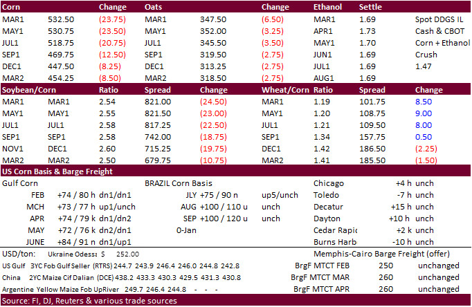
Corn.
-
Corn
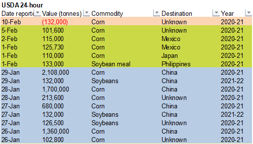
futures led the ag markets lower today, with the March contract down 21.75 cents, or off 4.3 percent. Follow through selling from a higher than expected US corn carryout reported yesterday was noted. USDA announced sales cancellations of 132,000 tons to
unknown. China slowed US feedgrain purchases, but the hard drop in corn futures could attract some light sales. Look for commercial buying to increase during the balance of the week if corn trends lower.
Nearly 89,000 H/K corn spreads traded. -
Funds
sold an estimated net 55,000 corn contracts.
I can’t recall over the past year when the funds sold that many contracts. But on October 28 they came close by unloading 53,000. On that day nearby corn fell 15 cents, or 3.5%.
-
On
Thursday Conab will update Brazilian corn and soybean supply. We expect them to start factoring a smaller second corn area due to slow seeding progress.
-
Goldman
roll – day 4. - Hong
Kong reported a swine fever outbreak resulting in the loss of 3,000 pigs.
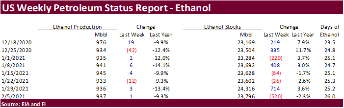
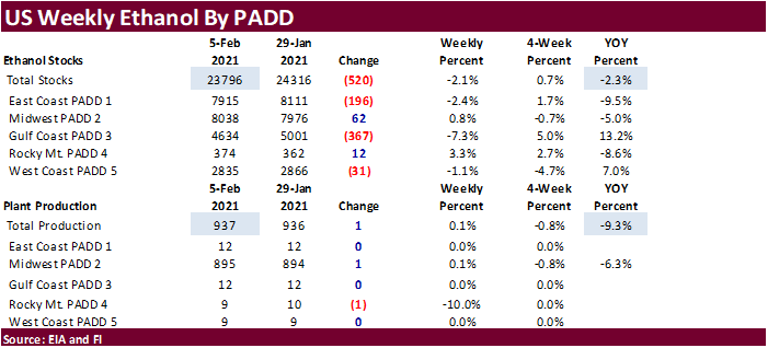
US
weekly ethanol production
increased 1,000 barrels per day while stocks dropped a large and unexpected 520,000 barrels. Note stocks were up 714,000 barrels for the previous week, so the change this week is viewed as a slight correction, in our opinion. September to date ethanol production
is running 8.3 percent below the same period a year ago. Recall ethanol consumptions started its decent around this time year ago. Weekly production of ethanol is currently on track that suggests corn use for 2020-21 will fall short of USDA’s 4.950 billion
estimate.
Corn
Export Developments
- USDA
announced 132,000 tons of corn was cancelled for unknown destination for 2020-21 marketing year.
Updated
2/10/21
March
corn is seen trading in a $5.20 and $6.00 range (lowered 10 cents, unch)
May
corn is seen in a $5.15 and $6.00 range.
July
is seen in a $5.00 and $6.00 range.
December
corn is seen in a $3.75-$5.50 range.