PDF Attached
Shoots
and ladders have been the theme over the recent few trading sessions. Today we saw cash buyers step in to pick up soybean meal. Rumors of China buying soybeans and corn added to the positive undertone. Look for volatility to remain in place for the balance
of this week, which is the balance of the month.
Weather
MOST
IMPORTANT WEATHER AROUND THE WORLD
- U.S.
hard red winter wheat production areas began receiving rain and snow overnight and the storm will prevail early this week lifting topsoil moisture in some of the drier biased areas - Moisture
totals through Tuesday morning will vary from 0.10 to 0.50 inch in eastern Colorado, parts of the Texas Panhandle, the Oklahoma Panhandle, far western Kansas and extreme southwestern Nebraska. Moisture totals farther to the east will vary from 0.40 to 1.00
inch with local amounts of 1.00 to 1.50 inches - Wettest
in southern Nebraska, northern Kansas and in a few areas from south-central into eastern fringes of Oklahoma crop areas - Total
snow accumulations will vary from 2 to 4 inches and local totals to 6 inches in eastern Colorado, far western Kansas and far southwestern Nebraska while 1 to 3 inches occur in central Kansas
- Snowfall
will be greatest in north-central and interior northwestern Kansas into central and eastern Nebraska where 6 to 12 inches and local totals to 15 inches are expected - The
moisture boost will be welcome and should translate into a better winter crop establishment potential in the spring after the northwestern hard red winter wheat production area had been much drier than usual in recent weeks.
- U.S.
Midwest will experience rain and snow early this week with sufficient precipitation to bolster topsoil moisture to the point of saturation once again - Today’s
soil moisture is rated adequately - Rainfall
in the lower Midwest will vary from 0.50 to 2.00 inches with the greatest amounts near and south of the Ohio River - There
is potential for locally more rain - Snowfall
will range from 6 to 12 inches from eastern Nebraska to central Iowa and up to 8 inches from northern Illinois to southern Michigan with a few amounts to 15 inches in southeastern Nebraska and southwestern Iowa - Snowfall
of 2 to 5 inches will surround this region - Northern
U.S. Delta and most of the southeastern states will receive precipitation during the early to middle part of this week - Moisture
totals of 0.65 to 1.50 inches will result except in the lower Delta and a small part of the southern Tennessee River Basin where amounts of 0.15 to 0.65 inch and local totals to 1.00 inch are possible - Northern
Alabama and Tennessee will be wettest - California
will receive the greatest precipitation seen so far this winter over the next five days - Snow
accumulations will be measured in feet across the Sierra Nevada and far northern mountains while rain in the valleys of central and northern California will range from 1.00 to 3.00 inches - A
few coastal areas between San Francisco and Los Angeles will receive more than 6.00 inches of rain resulting in flooding - Rain
and mountain snow will also fall in the Great Basin and southern Rocky Mountain region this week resulting in some needed soil moisture increases - Southwestern
Arizona and southeastern California will not receive much significant moisture - Northwestern
U.S. Plains and southwestern Canada’s Prairies will continue drier biased through the coming week as will the upper most Midwest; however, there will be some light and erratic precipitation - U.S.
weather next week will bring two more storms to areas east of the Rocky Mountains one during mid-week next week and the other during the following weekend
- There
is potential for some needed moisture to fall next week in the northern Plains. but confidence is low for getting drought relief to the northwestern Plains or southwestern Canada’s Prairies - West
Texas precipitation will be restricted over the next two weeks, but some showers will occur Friday into Saturday of this week - Some
rain of significance fell overnight in nearly 60% of West Texas with moisture totals of 0.20 to 1.19 inches resulting
- West-central
through northeastern parts of the region and some areas in the southeast half of the Texas Panhandle were wettest - South
Texas and Coastal Bend precipitation will stay restricted over the next two weeks
- U.S.
temperatures over the next two weeks will be seasonably cool in the west, near to above average in the northern Plains and a little warmer than usual in the southern Plains, Delta and southeastern states - U.S.
precipitation through Sunday afternoon was light, although rain fell in the southeastern states from southeastern Louisiana to southern Georgia and northwestern Florida and from the central and southern Rocky Mountain region into central and southern California - Moisture
totals were less than 0.60 inch most often - Light
rain and snow was noted across the northern Plains and the western Great Lakes region as well as from northeastern Colorado to southern Illinois and southern Missouri - A
winter storm evolved in the central Plains and spread moisture east into the lower Midwest, northern Delta and Tennessee River Basin overnight - Moisture
totals through dawn today varied from 1.00 to 2.14 inches in north-central Oklahoma, northwestern Arkansas, parts of southern Missouri, the northwestern Delta and parts of eastern Oklahoma
- Moisture
totals in the northwest half of Kansas, Nebraska and eastern Colorado as well as the northwest Texas Panhandle was less than 0.15 inch
- Snow
accumulations from eastern Colorado into Nebraska and northwestern Kansas through dawn varied from a dusting to 3 inches
- Lowest
weekend temperatures in Montana, Alberta and southwestern Saskatchewan fell near the wheat damage threshold while snow cover was minimal.
- World
Weather, Inc. does not believe much, if any, crop damage resulted - Lowest
temperatures were in the single digits Fahrenheit most often with a few subzero degree readings for a brief period of time - Argentina
rainfall during the weekend was minimal with a few showers in the far north and parts of northern Cordoba
- Net
drying resulted in most areas, although up to 0.80 inch occurred in northern Cordoba - Highest
temperatures were in the 90s Fahrenheit with a few extremes slightly over 100 in the far southwest of Buenos Aires and in west-central Santiago del Estero - Rain
will fall periodically and relatively frequently in northern Argentina and a little less frequent in central and especially southern areas - Rain
totals in the coming week will range from 0.75 to 2.00 inches in the central and north with some totals of 2.00 to more than 6.00 inches in the far northeast - Rain
totals in the south will vary from 0.15 to 0.75 inch except from central through northwestern Buenos Aires to southern Cordoba where 1.00 to 2.50 inches will be possible most of which occurs late this week and into the weekend - Net
drying is likely in Buenos Aires and La Pampa into Friday - Argentina’s
weather next week will wettest in northeastern Argentina - Southwestern
parts of the nation will be mostly dry through Thursday, Feb. 4 and then some rain is expected in the following weekend - Southern
Argentina will experience the east amount of rain during the next two week - Argentina
temperatures over the next two weeks will be seasonable with a slight warmer bias - Argentina’s
bottom line remains mostly good with a favorable mix of rain and sunshine expected over the next two weeks in central and northern parts of the nation. Portions of southern Argentina will struggle for well-timed rainfall, but many areas will get at least some
precipitation to slow the drying trend. Greater rain will still be needed in parts of La Pampa. Southwestern Buenos Aires and a few neighboring areas will be driest. No broad-based problem with moisture shortages are presently anticipated in key crop areas,
but a few areas in southwestern Buenos Aires and southern La Pampa will be a little too dry. A few areas in Entre Rios will also need greater rainfall in February to ensure ongoing good crop development and production potential.
- Brazil
weekend precipitation was greatest in Mato Grosso, Mato Grosso do Sul, Paraguay and eastern portions of both Parana and Santa Catarina - Rain
amounts were rarely more than 0.88 inch in key crop areas, although 1.00 to 2.67 inches occurred in Paraguay and upwards to 4.50 inches occurred in coastal Santa Catarina - Temperatures
were seasonable with highest afternoon temperatures in the 80s and lower to a few middle 90s Fahrenheit - Brazil’s
weather outlook for the next ten days has not changed much from that of late last week - Little
to not rain will fall from central Minas Gerais, northern Rio de Janeiro and Espirito Santo into the central parts of Bahia - Rainfall
in most other areas will range from 0.75 to 2.50 inches except in Paraguay into Rio Grande do Sul, western Santa Catarina and parts of Parana where 2.00 to 5.00 inches and a few local totals over 7.00 inches will result - Feb.
4-8 may perpetuate the same trend as noted above with center west, far southern and some center south crop areas getting daily showers and thunderstorms maintaining moisture abundance while interior parts of the northeast struggle to get significant moisture - Brazil’s
bottom line remains good for most of its summer grain, oilseed and cotton production areas as well as rice, sugarcane, citrus and some coffee areas. There is concern over coffee in unirrigated crop areas of Zona de Mata (east-central Minas Gerais, southern
Espirito Santo and northern Rio de Janeiro). Unirrigated crops in central through northern Minas Gerais to central Bahia will also have need for moisture to ease increasing crop stress. However, this latter area is not a big producer of corn or soybeans. Piaui
and eastern Tocantins as well as western Bahia should get enough rain to support crops even though amounts will be a little light. Early soybean maturation and harvest conditions will be fair to good in center west and center south crop areas, but excessive
rain in Paraguay, Santa Catarina and northern Rio Grande do Sul may result in some flooding.
- Many
areas in Canada’s Prairies are still snow free and only partial improvements to the situation are expected in the next ten days - Bitter
cold temperatures occurred in Russia’s New Lands and northern Canada during the weekend, but the extremes were well north of crop areas - Extreme
lows to -58 Fahrenheit (-50C) in Russia and to -51F (-46C) in northern Saskatchewan (north of crop areas) - India
was mostly dry during the weekend with a few showers in the extreme north and far south - India
will see little change for at least ten days, but showers are expected in northern and eastern India during February to help improve reproductive conditions for at least “some” crop areas - South
Africa reported some heavy rain in Limpopo and northeastern Mpumalanga during the weekend as Tropical Cyclone Eloise moved from central Mozambique into southern Botswana - Rainfall
reached 1.00 to 4.00 inches with local totals over 6.00 inches - Other
areas in South Africa reported net drying, although a few showers and thunderstorms occurred in central Eastern Cape and neighboring areas of southwestern Free State - Rain
totals varied from 0.10 to 0.43 inch with a few totals of 1.00 to 1.37 inches
- Temperatures
were hot in the west and seasonably warm in the central and east - South
Africa will experience a good mix of rain and sunshine over the next two weeks while temperatures are near to slightly below average - Summer
crops will thrive in this environment keeping yield potentials running high - Tropical
Cyclone Eloise moved inland through central Mozambique near Beira producing 99 mph wind speeds and rainfall to 8.00 inches with expectations of up to 12.00 inches before dry weather resumes - Damage
was considered moderate, but assessments were incomplete at the time of this report - No
crop damage assessments are available yet - Remnants
of the storm will have moved through southern Zimbabwe to southern Botswana with some moisture from this event eventually reaching into South Africa
- New
South Wales, Australia will receive frequent rainfall during the coming week to ten days bolstering soil moisture for improved dryland and irrigated cotton, sorghum and other crops - Queensland,
Australia is not likely to see much rain in key grain or cotton areas in the south, but rain will fall frequently in northern sugarcane areas - Snow
cover decreased in Europe during the weekend, but remained widespread in much of Ukraine, western and northern parts of Russia’s Southern Region and areas north to the Baltic States, northeastern Poland and the remainder of Russia - No
threatening cold was noted - Western
parts of the Commonwealth of Independent states and most of Europe will experience no threatening cold over the next ten days and warmer biased conditions will continue to melt snow from parts of western Russia, Ukraine and eastern Europe - Frequent
bouts of rain and snow will continue in Ukraine and western Russia as well as areas north into the Baltic States and western Russia - No
winterkill has occurred so far this winter and crop conditions are fair to very good with ongoing concern over low subsoil moisture in parts of Russia’s Southern Region and Kazakhstan - An
active weather pattern continues in Europe with little change likely through the next ten days - Some
potential for flooding may evolve in parts of western and southern Germany, France, Belgium, northern Spain, the upper coast of Portugal and the eastern Adriatic Sea nations - Winter
crops will remain dormant and in favorable condition - North
Africa will receive some showers over the coming ten days with north-central and northeastern Algeria, coastal Tunisia and far northern Morocco getting most of the moisture - Northwestern
Algeria and southwestern and far northeastern Morocco still need significant moisture to eliminate dryness - China
wheat and rapeseed are favorably rated and expected to perform well in the spring.
- There
is no threatening cold weather for the next two weeks and sufficient precipitation will fall to maintain status quo conditions - West
Africa rainfall will remain mostly confined to coastal areas while temperatures in the interior coffee, cocoa, sugarcane, rice and cotton areas are in a seasonable range for the next ten days - Some
rain fell in coastal areas of Ivory Coast and Ghana during the weekend, but key crop areas were dry - East-central
Africa rainfall will continue limited in Ethiopia as it should be at this time of year while frequent showers and thunderstorms impact Tanzania. - Kenya
and Uganda will receive some infrequent rainfall over the next ten days - Southern
Oscillation Index remained very strong during the weekend and was at +16.84 today and the index will drift lower over the next few days
- Southeast
Asia weather changed little during the weekend and not much change is expected this week - Mainland
areas were left mostly dry and that will persist - Philippines
rainfall was erratic and mostly light, but may increase somewhat during the next ten days - Indonesia
and Malaysia rainfall was erratic, but sufficient in maintaining a very good crop development environment - No
excessive rain occurred the past three days - Northern
and far southeastern Mexico will get most of the rain periodically during the next ten days - The
precipitation will be erratic and mostly light, but still welcome wherever it occurs - Many
areas in Mexico are still dealing with long term drought - Central
America precipitation will continue greatest along the Caribbean Coast while the Pacific Coast is relatively dry - Canada
Prairies will trend colder this week with some below average temperatures - Precipitation
will be periodic and mostly light - Southeast
Canada will experience restricted precipitation and seasonable temperatures over the coming ten days
Source:
World Weather Inc. and FI
Monday,
Jan. 25:
- USDA
weekly corn, soybean, wheat export inspections, 11am - USDA
total milk production - U.S.
cold storage data — pork, beef, poultry - Monthly
MARS report on EU crop conditions - Malaysia’s
Jan. 1-25 palm oil exports - EU
weekly grain, oilseed import and export data - Ivory
Coast cocoa arrivals
Tuesday,
Jan. 26:
- EARNINGS:
ADM - HOLIDAY:
India, Australia
Wednesday,
Jan. 27:
- EIA
weekly U.S. ethanol inventories, production, 10:30am - National
Coffee Association’s webinar on U.S. coffee outlook in 2021 - Paris
Grain Day virtual conference, day 1 - EARNINGS:
Barry Callebaut
Thursday,
Jan. 28:
- USDA
weekly crop net-export sales for corn, soybeans, wheat, cotton, pork, beef, 8:30am - USDA
releases Citrus Report on global demand and supply - Port
of Rouen data on French grain exports - Paris
Grain Day virtual conference, day 2 - HOLIDAY:
Malaysia
Friday,
Jan. 29:
- ICE
Futures Europe weekly commitments of traders report, 1:30pm (6:30pm London) - CFTC
commitments of traders weekly report on positions for various U.S. futures and options, 3:30pm - U.S.
agricultural prices paid, received - U.S.
cattle inventory
Source:
Bloomberg and FI
USDA
inspections versus Reuters trade range
Wheat
523,901 versus 200000-400000 range
Corn
1,391,455 versus 900000-1150000 range
Soybeans
1,978,971 versus 1000000-2100000 range
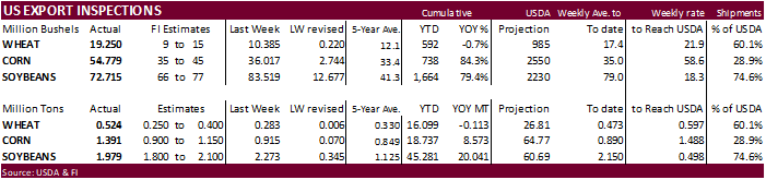
GRAINS
INSPECTED AND/OR WEIGHED FOR EXPORT
REPORTED IN WEEK ENDING JAN 21, 2021
— METRIC TONS —
————————————————————————-
CURRENT PREVIOUS
———–
WEEK ENDING ———- MARKET YEAR MARKET YEAR
GRAIN 01/21/2021 01/14/2021 01/23/2020 TO DATE TO DATE
BARLEY
0 2,395 416 23,339 17,662
CORN
1,391,455 914,880 680,459 18,736,777 10,164,040
FLAXSEED
0 24 0 485 396
MIXED
0 0 0 0 0
OATS
0 0 200 2,393 2,643
RYE
0 0 0 0 0
SORGHUM
179,182 159,495 142,217 2,817,949 1,130,975
SOYBEANS
1,978,971 2,273,005 1,059,997 45,280,876 25,240,343
SUNFLOWER
0 0 0 0 0
WHEAT
523,901 282,627 225,825 16,098,759 16,211,697
Total
4,073,509 3,632,426 2,109,114 82,960,578 52,767,756
CROP
MARKETING YEARS BEGIN JUNE 1 FOR WHEAT, RYE, OATS, BARLEY AND
FLAXSEED;
SEPTEMBER 1 FOR CORN, SORGHUM, SOYBEANS AND SUNFLOWER SEEDS.
INCLUDES
WATERWAY SHIPMENTS TO CANADA.
Corn.
-
Corn
futures were
higher out of the day session gate on rumors China bought US corn (4-5 cargoes) and soybeans (2-3). There were no USDA 24-hour announcements this morning but something to monitor for Tuesday.
Futures
saw a choppy trade overnight but light bottom picking paired some losses before the day session. Then prices rocketed higher, to stay at high levels until the close. The US weather situation is mostly unchanged and a large storm system moving across the upper
US Midwest that originated across the western states should provide good soil moisture precipitation. For SA, Argentina rains will ramp up this week that should limit crop deterioration.
-
We
may attribute the buying as commercial hedging today, and pan out during the rest of the week if we see business announced.
-
In
the meantime, CME decided to make some minor tweaks to their magin requirements, but the impact maybe very limited.
-
CME
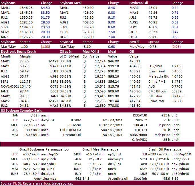
RAISES SOYBEAN FUTURES (C) MAINTENANCE MARGINS BY 1.7% TO $3,000 PER CONTRACT FROM $2,950 FOR MARCH 2021 -
CME
RAISES CORN FUTURES (C) MAINTENANCE MARGINS BY 7.7% TO $1,400 PER CONTRACT FROM $1,300 FOR MARCH 2021 -
USD
was 12 points higher, WTI 0.62 higher and gold DOWN $3.90 (was higher this morning). US stocks were mixed.
-
USDA
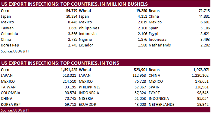
US corn export inspections as of January 21, 2021 were 1,391,455 tons, above a range of trade expectations, above 914,880 tons previous week and compares to 680,459 tons year ago. Major countries included Japan for 518,021 tons, Mexico for 214,510 tons, and
Taiwan for 93,195 tons. -
The
European Union granted imports licenses for 151,000 tons of corn imports, bringing cumulative 2020-21 imports to 9.455 MMT, 26 percent below same period year ago.
-
Sweden
culled a huge amount of chickens because of bird flu. 1.3 million checks were culled near the town of Monsteras on Jan. 18.
Corn
Export Developments
- None
reported
Updated
1/20/21
March
corn is seen trading in a $4.75 and $5.50 range. May corn could fall below $5.00, then trade down to $4.80-$4.90 area if US domestic and export demand slows.
-
CBOT
soybeans ended sharply higher after a strong start to the day session. Earlier traders were bearish eying the
50%
retracement in SH at $12.90. Over the weekend Egypt bought local soybean oil. Offshore values are indicating a higher trade in the products. Argentina will see increasing rains this week.
The
long liquidation on Friday was seen as overdone, per some comments. But managed money longs remain incredible long. March crush got slammed into the close, last trade down 7 cents. This was in part to very strong product values although offshore values
suggested a different story. On a positive note for soybeans….. -
USDA
US soybean export inspections as of January 21, 2021 were 1,978,971 tons, within a range of trade expectations, below 2,273,005 tons previous week and compares to 1,059,997 tons year ago. Major countries included China for 1,220,102 tons, Mexico for 179,651
tons, and Spain for 138,961 tons. -
SGS:
Malaysian palm exports for the Jan 1-25 period fell 34 percent to 847,534 tons. AmSpec reported a 35 percent decrease at 872,707 tons.
-
China
cash crush margins were 206 cents on our calculation, compared to 190 at the end of last week and to 84 year ago.
-
The
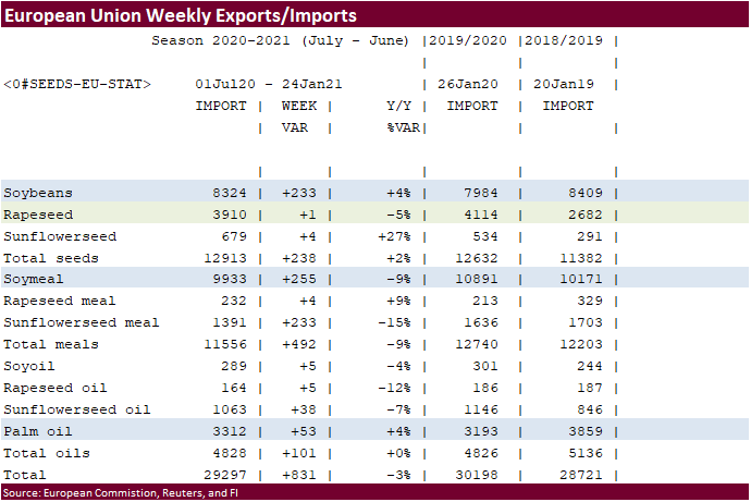
European Union reported soybean import licenses since July 1 at 8.324 million tons, below 7.984 million tons a year ago. European Union soybean meal import licenses are running at 9.933 million tons so far for 2020-21, below 10.891 million tons a year ago.
EU palm oil import licenses are running at 3.312 million tons for 2020-21, above 3.193 million tons a year ago, or up 4 percent -
European
Union rapeseed import licenses since July 1 were 3.910 million tons, down 5 percent from 4.114 million tons from the same period a year ago.
Oilseeds
Export Developments
- Egypt’s
GASC bought 6,000 of local soybean oil at $1,068/ton.
Updated
1/19/21
March
soybeans are seen in a $13.25 and $14.75 range (unchanged and down 25 cents)
March
soymeal is seen in a $410 and $480 range (down $10 & $20)
March
soybean oil is seen in a 41.00 and 43.50 cent range (down 1 & 2 cents, respectively)
- US
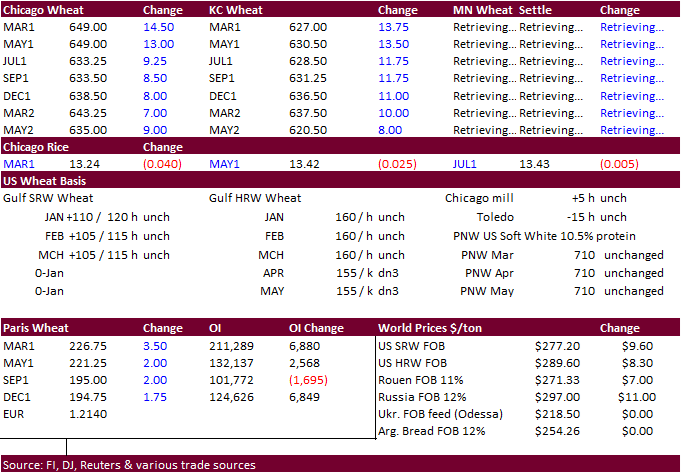
wheat futures saw a choppy overnight trade but followed corn and soybeans higher as traders still access global trade developments and currency moves. Prices could have been higher is we didn’t see some wheat import cancelations and/or deferments.
- The
market will be eyeing import tenders this week and any Russian export duty developments. As we near the close of the first month of the calendar year, don discount some positioning (selling).
- USDA
US all-wheat export inspections as of January 21, 2021 were 523,901 tons, above a range of trade expectations, above 282,627 tons previous week and compares to 225,825 tons year ago. Major countries included Japan for 112,963 tons, Mexico for 76,728 tons,
and Philippines for 57,367 tons. - EU
March milling wheat was up a large 3.50 at 226.75 euros. - China
sold nearly 4 million tons of wheat from state reserves at an average price of 2,455 yuan per ton.
- The
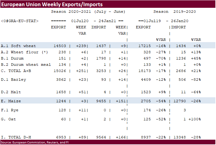
European Union granted export licenses for 239,000 tons of soft wheat exports, bringing cumulative 2020-21 soft wheat export commitments to 14.503 MMT, well down from 17.215 million tons committed at this time last year, a 16 percent decrease. Imports are
up slightly from year ago at 1.434 million tons.
-
Algeria’s
state grains agency OAIC seeks 50,000 tons of wheat on Jan. 27, valid up to Jan. 28, sourced from optional origins for shipment in two periods from March 1-15 and March 16-31.
-
Taiwan
launched an import tender for 85,340 tons of US wheat, set to close Jan 29, for late March through April 22 shipment.
-
Bangladesh
suspended an import tender for 50,000 tons of wheat. -
Saudi
Arabia bought 660,000 tons of barley at an average price pf $277.65/ton.
- Jordan
seeks 120,000 tons of animal feed barley on Jan. 26.
- Jordan’s
seeks 120,000 tons of milling wheat, optional origin, on Jan. 27.
- Japan’s
AgMin in a SBS import tender seeks 80,000 tons of feed wheat and 100,000 tons of feed barley for arrival by March 18, on January 27.
-
Results
awaited: Syria seeks 200,000 tons of wheat on Jan 18 for shipment within 60 days after contract signing.
·
Syria is in for 39,400 tons of rice on Feb 22. They are also in for 25,000 tons of rice on February 9.
- Bangladesh
seeks 50,000 tons of rice on January 26.
Updated
1/12/21
March
Chicago wheat is seen in a $6.35‐$7.15 range
March
KC wheat is seen in a $6.00‐$6.50 range
March
MN wheat is seen in a $6.00‐$6.55 range
Terry Reilly
Senior Commodity Analyst – Grain and Oilseeds
Futures International
One Lincoln Center
18 W 140 Butterfield Rd.
Oakbrook Terrace, Il. 60181
W: 312.604.1366
ICE IM:
treilly1
Skype: fi.treilly

Trading of futures, options, swaps and other derivatives is risky and is not suitable for all persons. All of these investment products are leveraged, and you can lose more than your initial deposit. Each investment product is offered
only to and from jurisdictions where solicitation and sale are lawful, and in accordance with applicable laws and regulations in such jurisdiction. The information provided here should not be relied upon as a substitute for independent research before making
your investment decisions. Futures International, LLC is merely providing this information for your general information and the information does not take into account any particular individual’s investment objectives, financial situation, or needs. All investors
should obtain advice based on their unique situation before making any investment decision. The contents of this communication and any attachments are for informational purposes only and under no circumstances should they be construed as an offer to buy or
sell, or a solicitation to buy or sell any future, option, swap or other derivative. The sources for the information and any opinions in this communication are believed to be reliable, but Futures International, LLC does not warrant or guarantee the accuracy
of such information or opinions. Futures International, LLC and its principals and employees may take positions different from any positions described in this communication. Past results are not necessarily indicative of future results.