Calls: Lower based om US weather US crop conditions wert good.
Conditions better than expected
We like selling rallies this week based on good US crop maturity for NA summer crops, southern Canada.
7-day future
US corn 57% G/E (exp 56% G/E) 58% last week and 62% yr ago
US soy 58% G/E (exp 58% G/E) 59% last week and 57% yr ago
US winter wheat harvested 90% (exp 92%) 86% last week and 97% yr ago
US spring wheat 64% G/E (exp 63% G/E) 64% last week and 11% yr ago
US spring wheat harvested 16% (exp 22%) 9% last week and 55% yr ago
Calls::
Corn up 2c to down 2c
Soybeans up 2c to down 3c
Wheat unch’d to up 4c
KC wheat unch’d to up 4c
Minny down 3c to up 2c
Meal up .50 to $1.00
SBO up 0.20 to 0.50
Monday’s selloff was likely overdone and influenced by outside markets. Funds sitting on the sidelines may dip their toes in again on value. Food inflation is still here and the main reason the commodities are down is due to demand destruction. Sovereigns are using the pullback to pick up cargoes.
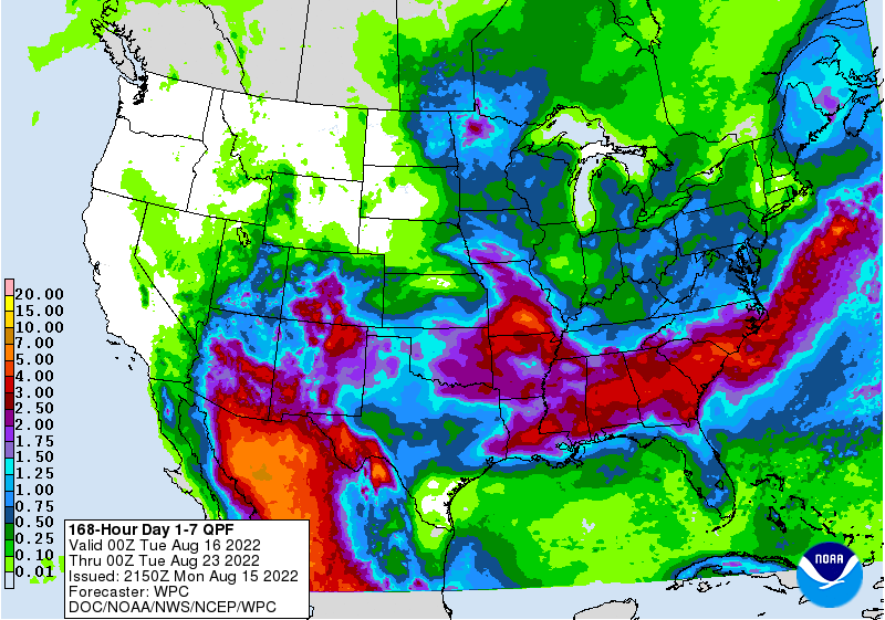
WEATHER TO WATCH AROUND THE WORLD
- U.S. forecast models are in better agreement today over rain expected in the western Corn and Soybean Belt today and Tuesday
- Relief from dryness is expected from South Dakota through southwestern Iowa to parts of Missouri, southwestern Illinois and eventually into the northern Delta
- Rainfall of 0.30 to 1.00 inch and local totals of 1.00 to 2.50 inches will result
- Additional moisture will be needed, but the cooler weather to follow the rain will help conserve the moisture and support better crop development
- Showers and thunderstorms will occur in most U.S. Midwest Corn and Soybean producing areas periodically in the next two weeks
- Not all areas will receive rain of significance and some areas of net drying are expected
- Other areas will get enough rain to hold crop and field conditions at status quo meaning no serious change from recent conditions
- Temperatures are still looking seasonably cool during the next two weeks with a few days of notably cooler than usual temperatures this week
- Some high temperatures will slip to the 60s and 70s Fahrenheit
- The cooler bias will help conserve soil moisture through slower evaporation
- When rain falls it will be less likely to be evaporated as quickly as it might in normal summer weather
- Northwestern United States will be warmer than usual in both this week and next week keeping livestock and crop stress running high
- High temperatures in the 90s to 104 degrees Fahrenheit during the second half of this week into next week after being in the 80s and 90s early this week
- Irrigation demand will remain strong as well
- West Texas, the Texas Blacklands and the Texas Panhandle will receive showers late Wednesday into Friday follow by a greater rainy period Aug. 21-24
- Rainfall late this week will vary from 0.15 to 0.70 inch with a few totals near or slightly above 1.00 inch
- Rainfall Aug. 21-24 “may” range from 0.75 to 2.0 inches with high coverage especially in West Texas cotton areas
- GFS model suggests much greater rain
- Some of this rain comes too late in the season to induce a serious improvement in crop production, although there will be some new plant growth and eventually new boll setting, but the bolls will be very small and may not change production very much.
- The moisture will be good for wheat planting in early September especially if follow up rain occurs late this month
- U.S. Delta and southeastern states will experience a good mix of rain and sunshine while experiencing seasonable temperatures during the next two weeks
- The environment will be great for summer crop development and production potential
- A tropical or subtropical disturbance that moved from Louisiana to southern Texas during the weekend produced 1.00 to 6.00 inches of rain along the Texas coast with similar rainfall occurring inland around the Kingsville area and extending southward toward the interior parts of far southern Texas
- The remnants of this disturbance will move up the Rio Grande Valley to New Mexico early this week with lighter amounts of rain expected
- The moisture comes too late to seriously change corn, sorghum or cotton development potential, but the moisture might be of use to fruit and vegetable crops
- More rain will be needed before drought is eliminated
- Far northeastern Mexico will also receive rain from the southern Texas weather disturbance early this week, but much more rain will be needed to end drought and very little change will come to crops in the region
- Southwestern Canada’s Prairies, the northwestern U.S. Plains and the U.S. Pacific Northwest will not get “meaningful” rain during the next ten days to two week resulting in net drying and additional late season crop stress
- Late season canola, corn, sunseed, and soybeans will be negatively impacted by the dryness, but only a small part of the region’s corn and soybeans are grown in the region and spring cereals are far enough advanced to be impacted in a minor way
- Accelerated crop maturation and harvest progress is expected for early season crops at least in this first week of the outlook
- Some showers may evolve next week briefly
- There is no risk of tropical cyclone development across the Atlantic Ocean over the next several days
- The bottom line for the United States remains one of temporary relief from dryness in the western Corn Belt where rain is expected today and Tuesday. Topsoil moisture Sunday was rated very short from central South Dakota through Nebraska and Kansas to the southwest half of Iowa and much of Missouri to a small part of the northern Delta. Subsoil moisture in the same region was rated marginally adequate to very short and crop stress is under way in portions of the region. Crop conditions farther to the east vary from fair to very good with only a few pockets of dryness. Yield potentials look very good for most crops in the central and eastern Midwest while the west “must” get a good drink of water in the next week to raise soil moisture while soybeans are filling pods and while late corn is filling and beginning to mature. The European and GFS models say rain will fall across the driest areas noted above today into Wednesday morning. If that verifies stress will be sufficiently relieved to carry crop development into late this month. Some follow up moisture is expected later this week and next week as well that should provide some additional relief from previous dryness.
- Ontario and Quebec, Canada, Manitoba Canada, eastern Saskatchewan, Canada and western, central and northern Alberta will get timely rain supporting coarse grain and oilseed development over the next two weeks.
- Argentina’s western wheat areas will continue drought stricken and waiting for significant rain
- Some showers are expected in the next two weeks, but resulting rainfall will not be great enough to seriously change crop or field conditions leaving an ongoing need for more rain
- Eastern Argentina wheat areas; including Buenos Aires and Entre Rios have good soil moisture and will receive timely rainfall to maintain a very good outlook for crop development in the early spring
- Argentina cotton harvest was 97% done as of last Thursday, maize harvesting was 94% done and sorghum 95% done
- Southern Brazil will remain plenty wet – if not a little too wet and some drying would be welcome
- Wheat areas in Parana and Rio Grande do Sul would benefit from some drier weather to reduce the potential for wet weather disease and protect grain quality during the harvest season that is quickly approaching in Parana.
- Cotton harvesting reached 80% complete as of August 6 in Goias, 54% in Minas Gerais, 38% in Maranhao, 86% in Mato Grosso do Sul, 75% in Bahia, 65% in Mato Grosso and 74% in Piaui (67% complete nationwide up from 57% last year)
- Europe weather during the weekend continued dry biased, but some rain developed in France and occurred from southern Italy into the western Balkan Countries as well as from Poland into Ukraine
- Rainfall in franked varied up to 0.75 inch while western Balkan Countries received 0.30 to 1.00 inch and a few local totals of 1.00 to 2.00 inches.
- Rain in western Ukraine ranged from 1.00 to nearly 3.00 inches in western Ukraine
- Temperatures continued very warm in western Europe with lower 90s Fahrenheit north into the U.K. and extremes to 104 in southwestern France
- Scattered showers will increase across Europe this week offering temporary relief to persistent dryness, but rarely will there be enough rain for a lasting change in soil moisture.
- Short term improvements in crop and field conditions are expected in some areas, but more rain will be needed to end drought
- Drier weather may resume for a little while during the weekend and especially next week
- Russia’s Southern Region will receive some needed showers Tuesday through Thursday of this week with 0.10 to 0.75 inch and a few amounts over 1.00 inch resulting
- Temporary relief from warm and dry weather is expected, but the warm and dry bias will resume this coming weekend and last through most of next week
- Temperatures will continue to be warmer than usual with frequent highs in the 90s to near 100 Fahrenheit except Tuesday through Thursday of this week at which time highs may briefly slip to the 80s and lower 90s
- Summer coarse grain and oilseed crops might be negatively impacted by the limited rainfall and warm bias that will prevail in unirrigated areas
- Western and central portions of Russia’s New Lands will be dry biased and warmer than usual during the next ten days to two weeks
- This may stress some sunseed, but may occur late enough to have a low impact on spring wheat
- China’s Yangtze River Basin continued to experience dry and hot weather during the weekend with little change likely for the coming week to ten days
- Sichuan reported extreme highs of 100 to 111 Fahrenheit while areas to the east reported extremes of 100 to 108.
- Rain was reported in Inner Mongolia, the North China Plain and northeastern provinces in China during the weekend and crop conditions remained mostly good, although a little wet in parts of the region
- Very little change in weather is expected in this region through the next ten days
- Xinjiang, China will continue to receive a good mix of weather during the next two weeks maintaining a favorable summer crop outlook for corn, cotton and other crops
- Xinjiang may be a little cooler than usual this week with a few showers expected
- India’s greatest rain during the weekend occurred form northeastern Odisha and Jharkhand through eastern Madhya Pradesh and northeastern Chhattisgarh to Rajasthan and central Pakistan
- Rainfall varied from 1.00 to 3.50 inches most often, although 3.50 to 6.00 inches occurred in Odisha, parts of Chhattisgarh and eastern Madhya Pradesh with one location in northeastern Odisha reporting 8.58 inches
- Gujarat, Maharashtra and southwestern Madhya Pradesh received 0.10 to 0.80 inch of rain while southern and far northern India were dry and warm
- Western and southern Rajasthan and central Pakistan reported 1.34 to 3.00 inches with one western Rajasthan location reporting 5.08 inches
- Waves of rain will continue across central India from Odisha, West Bengal and far northeastern Andhra Pradesh to Rajasthan and northeastern Gujarat through the next ten days
- Sufficient rain will fall to maintain saturated soil
- Some flooding is expected and a little crop damage is possible, but only in local areas and the impact on production should be low
- Far northern and southern India will not likely see nearly as much rain with net drying in the south
- Significant rain will fall in Pakistan as well as central India
- Rainfall this summer has been much greater than usual in Pakistan bolstering water supply and possibly supporting much larger than usual rice, cotton and other crops
- Australia weather will remain well mixed with rain and sunshine the next ten days
- Rain will fall in most of the wheat, barley and canola areas maintaining moisture abundance and keeping the crop poised for an excellent start to the growing season
- Korean Peninsula will receive waves of rain over the next two weeks resulting in significant soil moisture improvements
- Flooding is possible, although crop damage is not expected to be very serious
- Mainland areas of Southeast Asia will get plenty of rain, but nothing too extreme over the next ten days
- Philippines and Indonesia weather will continue frequently wet during the next ten days
- East-central Africa will be most significant in Ethiopia, although Uganda and Kenya rainfall is also expected to be favorable
- Flooding has been occurring in parts of Ethiopia recently and it may continue at times
- Tanzania is normally dry at this time of year and it should be that way for the next few of weeks
- West-central Africa rainfall has been and will continue sufficient to support coffee, cocoa, sugarcane, rice and cotton development normally
- Rain fell in central parts of Ivory Coast during the weekend easing recently dryness with rainfall of 0.25 to 2.50 inches
- Some greater rain would still be welcome in the drier areas of Ivory Coast and Ghana
- Seasonal rains have shifted northward leading to some drying in southern areas throughout west-central Africa – this is normal for this time of year
- Cotton areas are expecting frequent rainfall in the next couple of weeks with a few areas in Mali, northern Ivory Coast and Senegal becoming a little too wet
- South Africa’s crop moisture situation is favorable for winter crop establishment, although some rain would be welcome
- Restricted rainfall is expected for a while, but the crop is rated better than usual because of frequent rainfall during the autumn planting season and timely rain since then
- Crops are semi-dormant and unlikely to develop aggressively for a few weeks leaving plenty of time for seasonal rains to resume normally
- Central America rainfall will continue to be abundant to excessive and drying is needed
- Too much moisture could induce some areas of flooding
- Some crop conditions would improve with a little less rain
- Mexico rain will be most abundant in the west and southern parts of the nation
- Drought will prevail in the northeast, although there will be some increase in shower and thunderstorm activity near the Rio Grande for a while this week and in a more broad-based event next week as weather patterns change temporarily
- Rain in the Greater Antilles will occur periodically, but no excessive amounts are likely
- Rain in the past 30-days has been notably lighter than usual because of limited tropical activity
- No change in this drier bias is expected for a while
- Today’s Southern Oscillation Index was +10.37and it will move erratically over the next week
- New Zealand weather is expected to turn warmer this week with rain becoming heavy at times in North Island and in northern and western parts of South Island
- Some flooding will be possible
Source: World Weather INC
Bloomberg Ag Calendar
Monday, Aug. 15:
- USDA export inspections – corn, soybeans, wheat, 11am
- US crop conditions for wheat, corn, soybeans and cotton; wheat harvesting, 4pm
- Malaysia’s Aug 1-15 palm oil export data
- HOLIDAY: Argentina, France, India, Bangladesh
Tuesday, Aug. 16:
- New Zealand global dairy trade auction
- EU weekly grain, oilseed import and export data
Wednesday, Aug. 17:
- EIA weekly U.S. ethanol inventories, production, 10:30am
- HOLIDAY: Indonesia
Thursday, Aug. 18:
- China’s second batch of July trade data, including corn, pork and wheat imports
- International Grains Council report
- USDA weekly net-export sales for corn, soybeans, wheat, cotton, pork and beef, 8:30am
Friday, Aug. 19:
- ICE Futures Europe weekly commitments of traders report
- CFTC commitments of traders weekly report on positions for various U.S. futures and options, 3:30pm
- FranceAgriMer weekly update on crop conditions
- Brazil’s Conab releases sugar, cane and ethanol output data
- US cattle on feed, 3pm
- EARNINGS: Deere
Saturday, Aug. 20:
- China’s third batch of July trade data, including soy, corn and pork imports by country
- AmSpec to release Malaysia’s Aug. 1-20 palm oil export data
Source: Bloomberg and FI
USDA inspections versus Reuters trade range
Wheat 373,227 versus 250000-675000 range
Corn 538,406 versus 475000-800000 range
Soybeans 744,571 versus 300000-850000 range
Terry Reilly
Senior Commodity Analyst – Grain and Oilseeds
Futures International
One Lincoln Center
18 W 140 Butterfield Rd.
Oakbrook Terrace, Il. 60181
W: 312.604.1366
ICE IM: treilly1
Skype: fi.treilly

Trading of futures, options, swaps and other derivatives is risky and is not suitable for all persons. All of these investment products are leveraged, and you can lose more than your initial deposit. Each investment product is offered only to and from jurisdictions where solicitation and sale are lawful, and in accordance with applicable laws and regulations in such jurisdiction. The information provided here should not be relied upon as a substitute for independent research before making your investment decisions. Futures International, LLC is merely providing this information for your general information and the information does not take into account any particular individual’s investment objectives, financial situation, or needs. All investors should obtain advice based on their unique situation before making any investment decision. The contents of this communication and any attachments are for informational purposes only and under no circumstances should they be construed as an offer to buy or sell, or a solicitation to buy or sell any future, option, swap or other derivative. The sources for the information and any opinions in this communication are believed to be reliable, but Futures International, LLC does not warrant or guarantee the accuracy of such information or opinions. Futures International, LLC and its principals and employees may take positions different from any positions described in this communication. Past results are not necessarily indicative of future results.